Originally intended as volume 3 of a larger cartographic project (The English Atlas), Blome's Britannia was published alone in 1673. A rare second edition was issued in 1677. The Norfolk map is dedicated to Henry Howard, Earl of Norwich, and heir apparent to the Duke of Norfolk.
Camden's Britannia - a history and topography of Britain - was first published in 1586 and had a long and successful publication history. County maps by Kip and Hole were addded in 1607, and these also appeared in the editions of 1610 and 1637. Over 50 year's later it was decided to issue a new and updated edition. The original Latin text was re-translated by Edmund Gibson, and Robert Morden was commissioned to provide a new set of county and general maps in a more modern style. The revised work was issued in 1695. There were 4 further editions of the Gibson/Morden work, the last in 1772, before a further updated version by Richard Gough was launched in 1789, with new maps by John Cary. This is an attractively coloured example from one of the Gibson editions. A narrow left-hand margin. Modern colour.
H. Moll A Set of Fifty New and Correct Maps of the Counties of England and Wales / A New Description of England and Wales 1724-39
Herman Moll's maps of the English and Welsh counties were originally designed to illustrate the topographical work entitled A New Description of England and Wales which was first issued in 1724. The publishers (Moll himself, the Bowles brothers and C. Rivington) decided to also put them out as an atlas volume without text, which also appeared in 1724 under the title A Set of Fifty New and Correct Maps of the Counties of England and Wales. There were various later editions of both formats, the last in 1753. This example bears the plate number 22 which dates it to one of the earlier atlas editions of 1724 or 1739, or to the serialised re-issue of A New Description ... in 1733. A few closed marginal tears, one of which just enters the image of one of the coins to the left of the map border.
T. Kitchin The Antiquities of England and Wales c1789 (1748)
This map was first published in the February 1748 edition of the London Magazine, which between 1747 and 1754 issued a complete set of English county maps by Thomas Kitchin. The maps were later re-published by Alexander Hogg in Boswell's Antiquities of England & Wales, initially in partwork from c 1787-9, and then in several complete editions of the work up to 1798. This example of the Norfolk map is from the first complete edition of Boswell's Antiquities dating from c1789.
J. Ellis Ellis's English Atlas 1766 (1765)
Joseph Ellis's English Atlas was an entry into the market for small county atlases by its publishers Robert Sayer and Carington Bowles. The county maps were closely based upon those drawn by Thomas Kitchin for the 1763 topographical work England Illustrated, the major difference being the attractive vignettes which replaced Kitchin's rococco cartouches. The atlas was first published in 1765, and soon became a commercial success, running to many later editions. It was promoted as a travelling atlas, and made available in various formats. These included a version with the maps printed back to back on each page, as with this example from a 1766 edition which has a map of Northamptonshire on the reverse.
First published 1769 in Kitchin's Pocket Atlas, which was based on the novel concept of drawing all the county maps to a common scale. Whilst this provided a better illustation of counties' relative sizes, it meant that the overall sizes of the maps varied considerably. Smaller maps shared pages where this was practical within an alphabetical county arrangement, but Norfolk had a page to its self. The atlas was not commercially successful and Kitchin issued no further editions, although the plates were later acquired by Carington Bowles who re-issued the work as Bowles's Pocket Atlas around 1778. This example is from the latter work. Today maps from either atlas are quite scarce.
This entry into the popular market for miniature atlases and road books was first published by M.A. Leigh in 1820 under the title Leigh's New Pocket Atlas of England and Wales. The maps were engraved by Sidney Hall. There were several later editions up to 1843, under slightly changed titles. This example dates from 1834 or later - dated by Leigh's new address (421 Strand) in the imprint.
In c1849 maps from the Walkers' British Atlas were used for this new publication for the hunting enthusiast. The maps were overprinted and coloured to show the territories of the various hunts.The Atlas continued into the 1880's, later editions being titled "Walkers Fox-hunting Atlas" This example is from the first edition of 1849, so identified by the hunt name being overprinted in black outline and then hand coloured in blue. Later editions had the hunt names printed in blue.
J. Archer Curiosities of Great Britain, England and Wales Delineated 1842 or 1846 (1842)
This map by Joshua Archer first appeared in 1842 in Dugdale's Curiosities of Great Britain, England and Wales Delineated. There were several further editions of the work up to 1858, some with slight amendments to the title. This example is from the 1842 or 1846 editions of the work. Modern colour.
E. Bowen Large English Atlas 1768-79 (1749)
This new series of maps was commenced in 1749, with maps sold singly until the last counties were completed and the full series issued in 1760 as the Large English Atlas. Norfolk was first issued in 1749. The joint imprint of Carrington Bowles and Robert Sayer dates this example to c1768-1779. Repair to lower centrefold split and 2 small holes, but otherwise a nice copy in original outline colour.
J. Pigot A Pocket Topography and Gazetteer of England 1841
Published by Pigot and Slater in 1841 as a pocket gazetteer of the English counties, though some counties may have been available slightly earlier on a partwork basis. Original outline colour. A brown mark just outside the top border, and some old selotape marks to verso.
This item was probably a special order from the London map retailer Stanfords, whose lable it bears on the original, red slip case in which it is contained. It is there titled as "Ordnance Map of the Country Around Cromer, and comprises 4 sheets from the Ordnance Survey's one inch "New Series" - numbers 131,132,147 and 148. The sheets are dissected and linen backed and cover a coastal triangle encompassing Wells to the north-west, Ormesby St. Margaret to the south-east, and Swanton Morley to the south west. The map is in fine condition, and was once part of the map and local history collection of Ron Fiske.
Chorographia Britanniae was one of the most popular 18th century atlases, offering county maps showing main roads, a handy pocket-size format and useful extra information provided in the notes. A number of maps were not oriented with north at the top, including that of Norfolk where west is at the top.Maps from fhe first edition published in 1742 (but with maps dated 1741) initially had sparse topograhical information, but within a few months a second edition was issued in which the maps were re-engraved to include many more towns and villages. This example is from this second edition. Several later re-issues followed and the work continued to be advertised until at least 1759. Modern colour.
This small county atlas of England and Wales was first issued in 1748 by a consortium of 7 publishers who also had a stake in the publication of Daniel Defoe's Tour Through the Whole Island of Great Britain. It was advertised as a companion volume to Defoe's work, or as a pocket atlas in its own right. Thomas Hutchinson's name appears as the engraver on 2 maps, but the rest are unsigned and may be by a variety of hands. They are sometimes also known as Osborne/Wale maps. There was a second edition in 1756. Supplied mounted.
R. Blome England Exactly Described 1715 (1681)
Blome's smaller series of county maps have a puzzling history. They seem to have been initiated before his larger maps for Britannia, but were not published until 1681 when they appeared under the title Speed's Maps Epitomiz'd. Blome re-issued them twice before his death in 1705. The plates were subsequently acquired by Thomas Taylor who brought out a new edition in 1715 titled England Exactly Described. There were further editions in 1715 (by Taylor), and in c1731 (by Thomas Bakewell). These later editions had roads added to the maps. This example of the Norfolk map is from the 1715 edition of the work. Original hand colour. A narrow top left margin, but as printed and without loss. Supplied mounted.
The Blaeu's major sea Atlas, Der Zeespiegel, was first published in 1623, and was re-issued a number of times in both Dutch and English editions between 1623 and 1652. From 1655-66 it was re-issued in an expanded edition as De Groote Zeespiegel. This example is from a Dutch edition and traces the Norfolk and Suffolk coasts from Cromer to Orfordness. Despite the several original editions, the charts are today rare.
Laurie's Travellers Companion was first published as a road atlas in 1806 by Laurie and Whittle. It included ? regional maps by Nathaniel Coltman featuring the main road network as a series of straight lines linking towns en-route.There were a number of later editions, this example being from that of 1815.
This work was published in 1835 as a companion volume to Lewis's Topographic Dictionary. It contains county and borough maps, drawn by R. Creighton and engaved by J.& C. Walker, and was designed to show the electoral and boundary changes effected by the 1832 Reform Act. There were 2 issues of the work in 1835 and 1840, this example of the county map being from the 1835 first edition. Original outline colour.
Great Yarmounth. Between c 1720 and 1752 the brothers Samuel and Nathaniel Buck, produced over 300 engravings of topograhical antiquities, and 83 larger townscapes, the latter being particularly sought-after today. They were sold singly and in collected formats, being generally referred to as "Bucks Views". By 1780 the Bucks' copper plates had passed to Robert Sayer, one of the 18th century's most important publishers of maps and prints. Sayer republished the works, his edition differing from the original only in the addition of plate numbers. This view of Yarmouth is dated 1741, but has a plate number, thus dating it to the Sayer edition of the 1780's. Currently framed but could be de-framed if so desired.
Norwich Castle. The New British Traveller was one of a number of publications by Alexander Hogg aiming to tap the bouyant market for works on British topography and antiquities. It included text on each couny, a set of county maps by T. Conder and others, and numerous copperplate prints by a variety of engravers. The work was initially issued in 60 parts from c 1783, and then as a complete work from 1784. Norwich Castle was founded by William the conqueror and built from 1066-75. The keep was rebuilt in stone from 1095-1110. The castle was used as a gaol from 1220 to 1887, when it was bought by the city corporation and opened as a museum in 1895. It still serves as the city's museum and art gallery today.
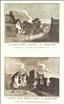
Castle Acre - the Castle and Monastery . The Antiquities of England and Wales was the product of Alexander Hogg who was well known as a partwork publisher. Under the claimed authorship of Henry Boswell it was issued serially from c1787-9, and subsequently made available as a complete work. The format was typically 2 (though sometimes up to 6) prints to a page, with one or two accompanying pages of descriptive text on each pair of subjects. It also included the set of English county maps by Thomas Kitchin first used in the London Magazine from 1747-54. The village of Castle Acre grew up around the castle from which it takes its name. The castle was founded by William de Warenne, 1st Earl of Surrey, soon after the Norman conquest. The Cluniac Priory was built in the castle grounds and consecrated between 1146 and 1148. The remains of both properties are today owned by the Earl of Leicester, but managed and opened to the public by English Heritage. This print, engraved by J. Wooding, offers views of both castle and priory, and is supplied with the original, accompanying text from the work.
Castle Acre Monastery . The Antiquities of England and Wales was the product of Alexander Hogg who was well known as a partwork publisher. Under the claimed authorship of Henry Boswell it was issued serially from c1787-9, and subsequently made available as a complete work. The format was typically 2 (though sometimes up to 6) prints to a page, with one or two accompanying pages of descriptive text on each pair of subjects. It also included the set of English county maps by Thomas Kitchin first used in the London Magazine from 1747-54. The Cluniac Priory was built in the grounds of the castle of Castle Acre, and was consecrated between 1148 and 1148. After the dissolution of the monasteries the priory fell into decay, eventually passing into the hands of the Earls of Leicester, who still own the site today. The ruins of both the priory and the castle are managed by English Heritage and open to the public.
Norwich Cathedral. The Antiquities of England and Wales was the product of Alexander Hogg who was well known as a partwork publisher. Under the claimed authorship of Henry Boswell it was issued serially from c1787-9, and subsequently made available as a complete work. The format was typically 2 (though sometimes up to 6) prints to a page, with one or two accompanying pages of descriptive text on each pair of subjects. It also included the set of English county maps by Thomas Kitchin first used in the London Magazine from 1747-54. The building of Norwich Cathedral began in 1096 and was completed in 1145. Its origianl wooden spire was rebuilt in stone in 1480, but, compared to many other cathedrals, Norwich's Norman plan and fabric is little changed today. This print, engraved by Thornton, is supplied with the original, accompanying text from the work.