
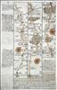
Pages 3/4 - High Wycombe, Tetsworth, Oxford, Islip, Morton-in-the-Marsh, Broadway. In 1720 Thomas Bowles and Emanuel Bowen published a new reduced version of John Ogilby's strip maps. Britannia Depicta came hot on the heels of the two reduced editions issued the previous year by Thomas Gardner and John Senex, but was much more innovative. Where Gardner and Senex had closely followed the strip layout and design of Ogilby, the new work further reduced the size of the volume, by including only 3 or 4 strips per page, and by printing on both sides of the page, but also added a considerable amount of additional detail by way of historical and topographical notes and heraldry. This additional information turned the work into much more than just a road book - it was virtually a guide book. This added detail was researched and provided by John Owen, who passed it to Bowen to incorporate into the layout and engraving of the pages. The work also included a set of English and Welsh county maps. Britannia Depicta became a great commercial success, and was re-issued a number of times up to 1764, with occasional amendments and additions.


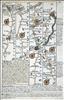
Pages 5/6 - Pershore, Worcester, Leominster, Presteigne. In 1720 Thomas Bowles and Emanuel Bowen published a new reduced version of John Ogilby's strip maps. Britannia Depicta came hot on the heels of the two reduced editions issued the previous year by Thomas Gardner and John Senex, but was much more innovative. Where Gardner and Senex had closely followed the strip layout and design of Ogilby, the new work further reduced the size of the volume, by including only 3 or 4 strips per page, and by printing on both sides of the page, but also added a considerable amount of additional detail by way of historical and topographical notes and heraldry. This additional information turned the work into much more than just a road book - it was virtually a guide book. This added detail was researched and provided by John Owen, who passed it to Bowen to incorporate into the layout and engraving of the pages. The work also included a set of English and Welsh county maps. Britannia Depicta became a great commercial success, and was re-issued a number of times up to 1764, with occasional amendments and additions. Modern hand colour.


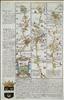
Pages 15/16 - Grantham, Newark, Tuxford, Doncaster. In 1720 Thomas Bowles and Emanuel Bowen published a new reduced version of John Ogilby's strip maps. Britannia Depicta came hot on the heels of the two reduced editions issued the previous year by Thomas Gardner and John Senex, but was much more innovative. Where Gardner and Senex had closely followed the strip layout and design of Ogilby, the new work further reduced the size of the volume, by including only 3 or 4 strips per page, and by printing on both sides of the page, but also added a considerable amount of additional detail by way of historical and topographical notes and heraldry. This additional information turned the work into much more than just a road book - it was virtually a guide book. This added detail was researched and provided by John Owen, who passed it to Bowen to incorporate into the layout and engraving of the pages. The work also included a set of English and Welsh county maps. Britannia Depicta became a great commercial success, and was re-issued a number of times up to 1764, with occasional amendments and additions.


Pages 17/18 - Ferrybridge, Tadcaster, York, Boroughbridge, Northallerton. In 1720 Thomas Bowles and Emanuel Bowen published a new reduced version of John Ogilby's strip maps. Britannia Depicta came hot on the heels of the two reduced editions issued the previous year by Thomas Gardner and John Senex, but was much more innovative. Where Gardner and Senex had closely followed the strip layout and design of Ogilby, the new work further reduced the size of the volume, by including only 3 or 4 strips per page, and by printing on both sides of the page, but also added a considerable amount of additional detail by way of historical and topographical notes and heraldry. This additional information turned the work into much more than just a road book - it was virtually a guide book. This added detail was researched and provided by John Owen, who passed it to Bowen to incorporate into the layout and engraving of the pages. The work also included a set of English and Welsh county maps. Britannia Depicta became a great commercial success, and was re-issued a number of times up to 1764, with occasional amendments and additions.


Pages 19/20 - Darlington, Durham, Chester-le-Street, Newcastle, Morpeth. In 1720 Thomas Bowles and Emanuel Bowen published a new reduced version of John Ogilby's strip maps. Britannia Depicta came hot on the heels of the two reduced editions issued the previous year by Thomas Gardner and John Senex, but was much more innovative. Where Gardner and Senex had closely followed the strip layout and design of Ogilby, the new work further reduced the size of the volume, by including only 3 or 4 strips per page, and by printing on both sides of the page, but also added a considerable amount of additional detail by way of historical and topographical notes and heraldry. This additional information turned the work into much more than just a road book - it was virtually a guide book. This added detail was researched and provided by John Owen, who passed it to Bowen to incorporate into the layout and engraving of the pages. The work also included a set of English and Welsh county maps. Britannia Depicta became a great commercial success, and was re-issued a number of times up to 1764, with occasional amendments and additions.
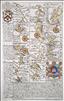
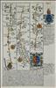
Pages 29/30 - Wendover, Aylesbury, Buckingham, Banbury, Stratford, Caughton. In 1720 Thomas Bowles and Emanuel Bowen published a new reduced version of John Ogilby's strip maps. Britannia Depicta came hot on the heels of the two reduced editions issued the previous year by Thomas Gardner and John Senex, but was much more innovative. Where Gardner and Senex had closely followed the strip layout and design of Ogilby, the new work further reduced the size of the volume, by including only 3 or 4 strips per page, and by printing on both sides of the page, but also added a considerable amount of additional detail by way of historical and topographical notes and heraldry. This additional information turned the work into much more than just a road book - it was virtually a guide book. This added detail was researched and provided by John Owen, who passed it to Bowen to incorporate into the layout and engraving of the pages. The work also included a set of English and Welsh county maps. Britannia Depicta became a great commercial success, and was re-issued a number of times up to 1764, with occasional amendments and additions. This example is from the first edition of 1720.


Pages 35/36 - Abingdon, Faringdon, Lechlade, Fairford, Gloucester, Mitcheldean, Monmouth. In 1720 Thomas Bowles and Emanuel Bowen published a new reduced version of John Ogilby's strip maps. Britannia Depicta came hot on the heels of the two reduced editions issued the previous year by Thomas Gardner and John Senex, but was much more innovative. Where Gardner and Senex had closely followed the strip layout and design of Ogilby, the new work further reduced the size of the volume, by including only 3 or 4 strips per page, and by printing on both sides of the page, but also added a considerable amount of additional detail by way of historical and topographical notes and heraldry. This additional information turned the work into much more than just a road book - it was virtually a guide book. This added detail was researched and provided by John Owen, who passed it to Bowen to incorporate into the layout and engraving of the pages. The work also included a set of English and Welsh county maps. Britannia Depicta became a great commercial success, and was re-issued a number of times up to 1764, with occasional amendments and additions.


Pages 39/40 - Burton, Swansea, Llanelli, Kidwelli, Haverfordwest, St. Davids. In 1720 Thomas Bowles and Emanuel Bowen published a new reduced version of John Ogilby's strip maps. Britannia Depicta came hot on the heels of the two reduced editions issued the previous year by Thomas Gardner and John Senex, but was much more innovative. Where Gardner and Senex had closely followed the strip layout and design of Ogilby, the new work further reduced the size of the volume, by including only 3 or 4 strips per page, and by printing on both sides of the page, but also added a considerable amount of additional detail by way of historical and topographical notes and heraldry. This additional information turned the work into much more than just a road book - it was virtually a guide book. This added detail was researched and provided by John Owen, who passed it to Bowen to incorporate into the layout and engraving of the pages. The work also included a set of English and Welsh county maps. Britannia Depicta became a great commercial success, and was re-issued a number of times up to 1764, with occasional amendments and additions.


Pages 43/4 - Sittingbourne, Preston (Faversham), Boughton St. Canterbury, Barham, Dover. In 1720 Thomas Bowles and Emanuel Bowen published a new reduced version of John Ogilby's strip maps. Britannia Depicta came hot on the heels of the two reduced editions issued the previous year by Thomas Gardner and John Senex, but was much more innovative. Where Gardner and Senex had closely followed the strip layout and design of Ogilby, the new work further reduced the size of the volume, by including only 3 or 4 strips per page, and by printing on both sides of the page, but also added a considerable amount of additional detail by way of historical and topographical notes and heraldry. This additional information turned the work into much more than just a road book - it was virtually a guide book. This added detail was researched and provided by John Owen, who passed it to Bowen to incorporate into the layout and engraving of the pages. The work also included a set of English and Welsh county maps. Britannia Depicta became a great commercial success, and was re-issued a number of times up to 1764, with occasional amendments and additions.

Pages 53/54 - Towcester, Daventry, Coventry, Coleshill, Lichfield. In 1720 Thomas Bowles and Emanuel Bowen published a new reduced version of John Ogilby's strip maps. Britannia Depicta came hot on the heels of the two reduced editions issued the previous year by Thomas Gardner and John Senex, but was much more innovative. Where Gardner and Senex had closely followed the strip layout and design of Ogilby, the new work further reduced the size of the volume, by including only 3 or 4 strips per page, and by printing on both sides of the page, but also added a considerable amount of additional detail by way of historical and topographical notes and heraldry. This additional information turned the work into much more than just a road book - it was virtually a guide book. This added detail was researched and provided by John Owen, who passed it to Bowen to incorporate into the layout and engraving of the pages. The work also included a set of English and Welsh county maps. Britannia Depicta became a great commercial success, and was re-issued a number of times up to 1764, with occasional amendments and additions.


Pages 59/60 - London, Brentford, Hounslow, Staines, Egham, Bagshot. In 1720 Thomas Bowles and Emanuel Bowen published a new reduced version of John Ogilby's strip maps. Britannia Depicta came hot on the heels of the two reduced editions issued the previous year by Thomas Gardner and John Senex, but was much more innovative. Where Gardner and Senex had closely followed the strip layout and design of Ogilby, the new work further reduced the size of the volume, by including only 3 or 4 strips per page, and by printing on both sides of the page, but also added a considerable amount of additional detail by way of historical and topographical notes and heraldry. This additional information turned the work into much more than just a road book - it was virtually a guide book. This added detail was researched and provided by John Owen, who passed it to Bowen to incorporate into the layout and engraving of the pages. The work also included a set of English and Welsh county maps. Britannia Depicta became a great commercial success, and was re-issued a number of times up to 1764, with occasional amendments and additions. On this example the road map is printed on one side of the page only, the verso carrying part of the description of London.


Pages 63/64 - Shaftesbury, Sherborne, Yeoveil, Axminster, Exeter, Chudleigh. In 1720 Thomas Bowles and Emanuel Bowen published a new reduced version of John Ogilby's strip maps. Britannia Depicta came hot on the heels of the two reduced editions issued the previous year by Thomas Gardner and John Senex, but was much more innovative. Where Gardner and Senex had closely followed the strip layout and design of Ogilby, the new work further reduced the size of the volume, by including only 3 or 4 strips per page, and by printing on both sides of the page, but also added a considerable amount of additional detail by way of historical and topographical notes and heraldry. This additional information turned the work into much more than just a road book - it was virtually a guide book. This added detail was researched and provided by John Owen, who passed it to Bowen to incorporate into the layout and engraving of the pages. The work also included a set of English and Welsh county maps. Britannia Depicta became a great commercial success, and was re-issued a number of times up to 1764, with occasional amendments and additions.


Pages 67/68 - Tregony, Penzanze, St. Buryon, Land's End. In 1720 Thomas Bowles and Emanuel Bowen published a new reduced version of John Ogilby's strip maps. Britannia Depicta came hot on the heels of the two reduced editions issued the previous year by Thomas Gardner and John Senex, but was much more innovative. Where Gardner and Senex had closely followed the strip layout and design of Ogilby, the new work further reduced the size of the volume, by including only 3 or 4 strips per page, and by printing on both sides of the page, but also added a considerable amount of additional detail by way of historical and topographical notes and heraldry. This additional information turned the work into much more than just a road book - it was virtually a guide book. This added detail was researched and provided by John Owen, who passed it to Bowen to incorporate into the layout and engraving of the pages. The work also included a set of English and Welsh county maps. Britannia Depicta became a great commercial success, and was re-issued a number of times up to 1764, with occasional amendments and additions. This example is from the first edition of 1720. It has a road map on one side only, the verso carrying part of the description of London.


Pages 75/76 - Woodgate, Lamberhurst, Hawkhurst Newended, Rye. In 1720 Thomas Bowles and Emanuel Bowen published a new reduced version of John Ogilby's strip maps. Britannia Depicta came hot on the heels of the two reduced editions issued the previous year by Thomas Gardner and John Senex, but was much more innovative. Where Gardner and Senex had closely followed the strip layout and design of Ogilby, the new work further reduced the size of the volume, by including only 3 or 4 strips per page, and by printing on both sides of the page, but also added a considerable amount of additional detail by way of historical and topographical notes and heraldry. This additional information turned the work into much more than just a road book - it was virtually a guide book. This added detail was researched and provided by John Owen, who passed it to Bowen to incorporate into the layout and engraving of the pages. The work also included a set of English and Welsh county maps. Britannia Depicta became a great commercial success, and was re-issued a number of times up to 1764, with occasional amendments and additions. This example has a road map on one side only, the verso carrying part of the description of London.

Pages 77/78 - Andover, Amesbury, Warminster. In 1720 Thomas Bowles and Emanuel Bowen published a new reduced version of John Ogilby's strip maps. Britannia Depicta came hot on the heels of the two reduced editions issued the previous year by Thomas Gardner and John Senex, but was much more innovative. Where Gardner and Senex had closely followed the strip layout and design of Ogilby, the new work further reduced the size of the volume, by including only 3 or 4 strips per page, and by printing on both sides of the page, but also added a considerable amount of additional detail by way of historical and topographical notes and heraldry. This additional information turned the work into much more than just a road book - it was virtually a guide book. This added detail was researched and provided by John Owen, who passed it to Bowen to incorporate into the layout and engraving of the pages. The work also included a set of English and Welsh county maps. Britannia Depicta became a great commercial success, and was re-issued a number of times up to 1764, with occasional amendments and additions. This example has a rpad map on one side only, the verso carrying part of the description of London. It is from the first edition of 1720

Pages 79/80 - Maiden Bradley, Bruton, Bridgewater, Dulverton. In 1720 Thomas Bowles and Emanuel Bowen published a new reduced version of John Ogilby's strip maps. Britannia Depicta came hot on the heels of the two reduced editions issued the previous year by Thomas Gardner and John Senex, but was much more innovative. Where Gardner and Senex had closely followed the strip layout and design of Ogilby, the new work further reduced the size of the volume, by including only 3 or 4 strips per page, and by printing on both sides of the page, but also added a considerable amount of additional detail by way of historical and topographical notes and heraldry. This additional information turned the work into much more than just a road book - it was virtually a guide book. This added detail was researched and provided by John Owen, who passed it to Bowen to incorporate into the layout and engraving of the pages. The work also included a set of English and Welsh county maps. Britannia Depicta became a great commercial success, and was re-issued a number of times up to 1764, with occasional amendments and additions.


Pages 81/82 - South Molton, Barnstaple, Torrington, Launceston, Camelford. In 1720 Thomas Bowles and Emanuel Bowen published a new reduced version of John Ogilby's strip maps. Britannia Depicta came hot on the heels of the two reduced editions issued the previous year by Thomas Gardner and John Senex, but was much more innovative. Where Gardner and Senex had closely followed the strip layout and design of Ogilby, the new work further reduced the size of the volume, by including only 3 or 4 strips per page, and by printing on both sides of the page, but also added a considerable amount of additional detail by way of historical and topographical notes and heraldry. This additional information turned the work into much more than just a road book - it was virtually a guide book. This added detail was researched and provided by John Owen, who passed it to Bowen to incorporate into the layout and engraving of the pages. The work also included a set of English and Welsh county maps. Britannia Depicta became a great commercial success, and was re-issued a number of times up to 1764, with occasional amendments and additions. This example is from the first edition of 1720.


Pages 87/88 - Stilton, Peterborough, Crowland, Spalding, Purfleet. In 1720 Thomas Bowles and Emanuel Bowen published a new reduced version of John Ogilby's strip maps. Britannia Depicta came hot on the heels of the two reduced editions issued the previous year by Thomas Gardner and John Senex, but was much more innovative. Where Gardner and Senex had closely followed the strip layout and design of Ogilby, the new work further reduced the size of the volume, by including only 3 or 4 strips per page, and by printing on both sides of the page, but also added a considerable amount of additional detail by way of historical and topographical notes and heraldry. This additional information turned the work into much more than just a road book - it was virtually a guide book. This added detail was researched and provided by John Owen, who passed it to Bowen to incorporate into the layout and engraving of the pages. The work also included a set of English and Welsh county maps. Britannia Depicta became a great commercial success, and was re-issued a number of times up to 1764, with occasional amendments and additions. This example is from the first edition of 1720.


Pages 93/94 - Garstang, Lancaster, Kendal. Perith, Carlisle. In 1720 Thomas Bowles and Emanuel Bowen published a new reduced version of John Ogilby's strip maps. Britannia Depicta came hot on the heels of the two reduced editions issued the previous year by Thomas Gardner and John Senex, but was much more innovative. Where Gardner and Senex had closely followed the strip layout and design of Ogilby, the new work further reduced the size of the volume, by including only 3 or 4 strips per page, and by printing on both sides of the page, but also added a considerable amount of additional detail by way of historical and topographical notes and heraldry. This additional information turned the work into much more than just a road book - it was virtually a guide book. This added detail was researched and provided by John Owen, who passed it to Bowen to incorporate into the layout and engraving of the pages. The work also included a set of English and Welsh county maps. Britannia Depicta became a great commercial success, and was re-issued a number of times up to 1764, with occasional amendments and additions.This example is from the first edition of 1720.


Pages 101/102 - Tempsford, St. Neots, Stilton, Peterborough. In 1720 Thomas Bowles and Emanuel Bowen published a new reduced version of John Ogilby's strip maps. Britannia Depicta came hot on the heels of the two reduced editions issued the previous year by Thomas Gardner and John Senex, but was much more innovative. Where Gardner and Senex had closely followed the strip layout and design of Ogilby, the new work further reduced the size of the volume, by including only 3 or 4 strips per page, and by printing on both sides of the page, but also added a considerable amount of additional detail by way of historical and topographical notes and heraldry. This additional information turned the work into much more than just a road book - it was virtually a guide book. This added detail was researched and provided by John Owen, who passed it to Bowen to incorporate into the layout and engraving of the pages. The work also included a set of English and Welsh county maps. Britannia Depicta became a great commercial success, and was re-issued a number of times up to 1764, with occasional amendments and additions. Modern colour.


Pages 103/104 - Market Deeping, Bourne, Sleaford, Lincoln, Brigg, Barton-upon-Humber. In 1720 Thomas Bowles and Emanuel Bowen published a new reduced version of John Ogilby's strip maps. Britannia Depicta came hot on the heels of the two reduced editions issued the previous year by Thomas Gardner and John Senex, but was much more innovative. Where Gardner and Senex had closely followed the strip layout and design of Ogilby, the new work further reduced the size of the volume, by including only 3 or 4 strips per page, and by printing on both sides of the page, but also added a considerable amount of additional detail by way of historical and topographical notes and heraldry. This additional information turned the work into much more than just a road book - it was virtually a guide book. This added detail was researched and provided by John Owen, who passed it to Bowen to incorporate into the layout and engraving of the pages. The work also included a set of English and Welsh county maps. Britannia Depicta became a great commercial success, and was re-issued a number of times up to 1764, with occasional amendments and additions.


Pages 111/112 - Tenby, Ludlow, Bishop's Castle, Montgomery. In 1720 Thomas Bowles and Emanuel Bowen published a new reduced version of John Ogilby's strip maps. Britannia Depicta came hot on the heels of the two reduced editions issued the previous year by Thomas Gardner and John Senex, but was much more innovative. Where Gardner and Senex had closely followed the strip layout and design of Ogilby, the new work further reduced the size of the volume, by including only 3 or 4 strips per page, and by printing on both sides of the page, but also added a considerable amount of additional detail by way of historical and topographical notes and heraldry. This additional information turned the work into much more than just a road book - it was virtually a guide book. This added detail was researched and provided by John Owen, who passed it to Bowen to incorporate into the layout and engraving of the pages. The work also included a set of English and Welsh county maps. Britannia Depicta became a great commercial success, and was re-issued a number of times up to 1764, with occasional amendments and additions. This example has a road map on one side only, the verso carrying a description of the Bedford Levels.


Pages 121/122 - Oakham, Melton Mowbray, Nottingham, Mansfield, Clowne, Rotherham, Barnsley. In 1720 Thomas Bowles and Emanuel Bowen published a new reduced version of John Ogilby's strip maps. Britannia Depicta came hot on the heels of the two reduced editions issued the previous year by Thomas Gardner and John Senex, but was much more innovative. Where Gardner and Senex had closely followed the strip layout and design of Ogilby, the new work further reduced the size of the volume, by including only 3 or 4 strips per page, and by printing on both sides of the page, but also added a considerable amount of additional detail by way of historical and topographical notes and heraldry. This additional information turned the work into much more than just a road book - it was virtually a guide book. This added detail was researched and provided by John Owen, who passed it to Bowen to incorporate into the layout and engraving of the pages. The work also included a set of English and Welsh county maps. Britannia Depicta became a great commercial success, and was re-issued a number of times up to 1764, with occasional amendments and additions.


Pages 123/124 - Barnsley, Halifax, Keighley, Skipton, Kettlewell, Richmond. In 1720 Thomas Bowles and Emanuel Bowen published a new reduced version of John Ogilby's strip maps. Britannia Depicta came hot on the heels of the two reduced editions issued the previous year by Thomas Gardner and John Senex, but was much more innovative. Where Gardner and Senex had closely followed the strip layout and design of Ogilby, the new work further reduced the size of the volume, by including only 3 or 4 strips per page, and by printing on both sides of the page, but also added a considerable amount of additional detail by way of historical and topographical notes and heraldry. This additional information turned the work into much more than just a road book - it was virtually a guide book. This added detail was researched and provided by John Owen, who passed it to Bowen to incorporate into the layout and engraving of the pages. The work also included a set of English and Welsh county maps. Britannia Depicta became a great commercial success, and was re-issued a number of times up to 1764, with occasional amendments and additions. Modern colour.


Pages 129/130 - Bagshot, Farnham, Alton, Alresford, Southampton; and Southampton, Romsey, Salisbury. In 1720 Thomas Bowles and Emanuel Bowen published a new reduced version of John Ogilby's strip maps. Britannia Depicta came hot on the heels of the two reduced editions issued the previous year by Thomas Gardner and John Senex, but was much more innovative. Where Gardner and Senex had closely followed the strip layout and design of Ogilby, the new work further reduced the size of the volume, by including only 3 or 4 strips per page, and by printing on both sides of the page, but also added a considerable amount of additional detail by way of historical and topographical notes and heraldry. This additional information turned the work into much more than just a road book - it was virtually a guide book. This added detail was researched and provided by John Owen, who passed it to Bowen to incorporate into the layout and engraving of the pages. The work also included a set of English and Welsh county maps. Britannia Depicta became a great commercial success, and was re-issued a number of times up to 1764, with occasional amendments and additions. This example is from the 1720 first edition of the work.


Pages135/136 Basingstoke, Stockbridge, Cranborne, Blandford, Dorchester, Weymouth. In 1720 Thomas Bowles and Emanuel Bowen published a new reduced version of John Ogilby's strip maps. Britannia Depicta came hot on the heels of the two reduced editions issued the previous year by Thomas Gardner and John Senex, but was much more innovative. Where Gardner and Senex had closely followed the strip layout and design of Ogilby, the new work further reduced the size of the volume, by including only 3 or 4 strips per page, and by printing on both sides of the page, but also added a considerable amount of additional detail by way of historical and topographical notes and heraldry. This additional information turned the work into much more than just a road book - it was virtually a guide book. This added detail was researched and provided by John Owen, who passed it to Bowen to incorporate into the layout and engraving of the pages. The work also included a set of English and Welsh county maps. Britannia Depicta became a great commercial success, and was re-issued a number of times up to 1764, with occasional amendments and additions. This example if from the first edition of 1720.


Pages 145/146 - Hereford, Leominster, Ludlow, Church Stretton, Shrewsbury. In 1720 Thomas Bowles and Emanuel Bowen published a new reduced version of John Ogilby's strip maps. Britannia Depicta came hot on the heels of the two reduced editions issued the previous year by Thomas Gardner and John Senex, but was much more innovative. Where Gardner and Senex had closely followed the strip layout and design of Ogilby, the new work further reduced the size of the volume, by including only 3 or 4 strips per page, and by printing on both sides of the page, but also added a considerable amount of additional detail by way of historical and topographical notes and heraldry. This additional information turned the work into much more than just a road book - it was virtually a guide book. This added detail was researched and provided by John Owen, who passed it to Bowen to incorporate into the layout and engraving of the pages. The work also included a set of English and Welsh county maps. Britannia Depicta became a great commercial success, and was re-issued a number of times up to 1764, with occasional amendments and additions.


Pages 149/150 - Bristol, Wells, Glastonbury, Taunton, Wellington, Exeter. In 1720 Thomas Bowles and Emanuel Bowen published a new reduced version of John Ogilby's strip maps. Britannia Depicta came hot on the heels of the two reduced editions issued the previous year by Thomas Gardner and John Senex, but was much more innovative. Where Gardner and Senex had closely followed the strip layout and design of Ogilby, the new work further reduced the size of the volume, by including only 3 or 4 strips per page, and by printing on both sides of the page, but also added a considerable amount of additional detail by way of historical and topographical notes and heraldry. This additional information turned the work into much more than just a road book - it was virtually a guide book. This added detail was researched and provided by John Owen, who passed it to Bowen to incorporate into the layout and engraving of the pages. The work also included a set of English and Welsh county maps. Britannia Depicta became a great commercial success, and was re-issued a number of times up to 1764, with occasional amendments and additions.


Pages 161/162 - Jedburgh, Berwick / Carlisle, Berwick. In 1720 Thomas Bowles and Emanuel Bowen published a new reduced version of John Ogilby's strip maps. Britannia Depicta came hot on the heels of the two reduced editions issued the previous year by Thomas Gardner and John Senex, but was much more innovative. Where Gardner and Senex had closely followed the strip layout and design of Ogilby, the new work further reduced the size of the volume, by including only 3 or 4 strips per page, and by printing on both sides of the page, but also added a considerable amount of additional detail by way of historical and topographical notes and heraldry. This additional information turned the work into much more than just a road book - it was virtually a guide book. This added detail was researched and provided by John Owen, who passed it to Bowen to incorporate into the layout and engraving of the pages. The work also included a set of English and Welsh county maps. Britannia Depicta became a great commercial success, and was re-issued a number of times up to 1764, with occasional amendments and additions. This sheet has the road map on one side only, the verso carrying a text description of Cambridge University. Modern colour.
Pages 165/166 - Llanfillyn, Tregynon, Llanbadarn, Fynydd, Builth Wells, Brecon. In 1720 Thomas Bowles and Emanuel Bowen published a new reduced version of John Ogilby's strip maps. Britannia Depicta came hot on the heels of the two reduced editions issued the previous year by Thomas Gardner and John Senex, but was much more innovative. Where Gardner and Senex had closely followed the strip layout and design of Ogilby, the new work further reduced the size of the volume, by including only 3 or 4 strips per page, and by printing on both sides of the page, but also added a considerable amount of additional detail by way of historical and topographical notes and heraldry. This additional information turned the work into much more than just a road book - it was virtually a guide book. This added detail was researched and provided by John Owen, who passed it to Bowen to incorporate into the layout and engraving of the pages. The work also included a set of English and Welsh county maps. Britannia Depicta became a great commercial success, and was re-issued a number of times up to 1764, with occasional amendments and additions.


Pages 169/170 - Dartmouth, Newton Abbot, Exeter, Tiverton, Bampton, Mnehead. In 1720 Thomas Bowles and Emanuel Bowen published a new reduced version of John Ogilby's strip maps. Britannia Depicta came hot on the heels of the two reduced editions issued the previous year by Thomas Gardner and John Senex, but was much more innovative. Where Gardner and Senex had closely followed the strip layout and design of Ogilby, the new work further reduced the size of the volume, by including only 3 or 4 strips per page, and by printing on both sides of the page, but also added a considerable amount of additional detail by way of historical and topographical notes and heraldry. This additional information turned the work into much more than just a road book - it was virtually a guide book. This added detail was researched and provided by John Owen, who passed it to Bowen to incorporate into the layout and engraving of the pages. The work also included a set of English and Welsh county maps. Britannia Depicta became a great commercial success, and was re-issued a number of times up to 1764, with occasional amendments and additions.


Pages 173/174 - Llanarth, Lyanrhystud, Talybont, Machynlleth, Llanymawddwy, Llangower, Llyn Tegid, . In 1720 Thomas Bowles and Emanuel Bowen published a new reduced version of John Ogilby's strip maps. Britannia Depicta came hot on the heels of the two reduced editions issued the previous year by Thomas Gardner and John Senex, but was much more innovative. Where Gardner and Senex had closely followed the strip layout and design of Ogilby, the new work further reduced the size of the volume, by including only 3 or 4 strips per page, and by printing on both sides of the page, but also added a considerable amount of additional detail by way of historical and topographical notes and heraldry. This additional information turned the work into much more than just a road book - it was virtually a guide book. This added detail was researched and provided by John Owen, who passed it to Bowen to incorporate into the layout and engraving of the pages. The work also included a set of English and Welsh county maps. Britannia Depicta became a great commercial success, and was re-issued a number of times up to 1764, with occasional amendments and additions. This example is from the first edition of 1720.


Pages 175/176 - Bala, Betws, Gwerfil Goch, Ruthin, Holywell . In 1720 Thomas Bowles and Emanuel Bowen published a new reduced version of John Ogilby's strip maps. Britannia Depicta came hot on the heels of the two reduced editions issued the previous year by Thomas Gardner and John Senex, but was much more innovative. Where Gardner and Senex had closely followed the strip layout and design of Ogilby, the new work further reduced the size of the volume, by including only 3 or 4 strips per page, and by printing on both sides of the page, but also added a considerable amount of additional detail by way of historical and topographical notes and heraldry. This additional information turned the work into much more than just a road book - it was virtually a guide book. This added detail was researched and provided by John Owen, who passed it to Bowen to incorporate into the layout and engraving of the pages. The work also included a set of English and Welsh county maps. Britannia Depicta became a great commercial success, and was re-issued a number of times up to 1764, with occasional amendments and additions. This example has a road map to one side only, the verso carrying a description of Exeter.


Pages 189/190 - Hereford, Worcester, Droitwich, Bromsgrove, Solihull, Coventry, Sharnford, Leicester. In 1720 Thomas Bowles and Emanuel Bowen published a new reduced version of John Ogilby's strip maps. Britannia Depicta came hot on the heels of the two reduced editions issued the previous year by Thomas Gardner and John Senex, but was much more innovative. Where Gardner and Senex had closely followed the strip layout and design of Ogilby, the new work further reduced the size of the volume, by including only 3 or 4 strips per page, and by printing on both sides of the page, but also added a considerable amount of additional detail by way of historical and topographical notes and heraldry. This additional information turned the work into much more than just a road book - it was virtually a guide book. This added detail was researched and provided by John Owen, who passed it to Bowen to incorporate into the layout and engraving of the pages. The work also included a set of English and Welsh county maps. Britannia Depicta became a great commercial success, and was re-issued a number of times up to 1764, with occasional amendments and additions.

Pages 195/196 - Ipswich, Norwich, Aylsham, Cromer. In 1720 Thomas Bowles and Emanuel Bowen published a new reduced version of John Ogilby's strip maps. Britannia Depicta came hot on the heels of the two reduced editions issued the previous year by Thomas Gardner and John Senex, but was much more innovative. Where Gardner and Senex had closely followed the strip layout and design of Ogilby, the new work further reduced the size of the volume, by including only 3 or 4 strips per page, and by printing on both sides of the page, but also added a considerable amount of additional detail by way of historical and topographical notes and heraldry. This additional information turned the work into much more than just a road book - it was virtually a guide book. This added detail was researched and provided by John Owen, who passed it to Bowen to incorporate into the layout and engraving of the pages. The work also included a set of English and Welsh county maps. Britannia Depicta became a great commercial success, and was re-issued a number of times up to 1764, with occasional amendments and additions.


Pages 201/202 - King's Lynn, Billingford, Norwich, Great Yarmouth. In 1720 Thomas Bowles and Emanuel Bowen published a new reduced version of John Ogilby's strip maps. Britannia Depicta came hot on the heels of the two reduced editions issued the previous year by Thomas Gardner and John Senex, but was much more innovative. Where Gardner and Senex had closely followed the strip layout and design of Ogilby, the new work further reduced the size of the volume, by including only 3 or 4 strips per page, and by printing on both sides of the page, but also added a considerable amount of additional detail by way of historical and topographical notes and heraldry. This additional information turned the work into much more than just a road book - it was virtually a guide book. This added detail was researched and provided by John Owen, who passed it to Bowen to incorporate into the layout and engraving of the pages. The work also included a set of English and Welsh county maps. Britannia Depicta became a great commercial success, and was re-issued a number of times up to 1764, with occasional amendments and additions.


Pages 207/208 - Nottingham, Newark, Lincoln, Market Rased, Brigsley, Grimsby. In 1720 Thomas Bowles and Emanuel Bowen published a new reduced version of John Ogilby's strip maps. Britannia Depicta came hot on the heels of the two reduced editions issued the previous year by Thomas Gardner and John Senex, but was much more innovative. Where Gardner and Senex had closely followed the strip layout and design of Ogilby, the new work further reduced the size of the volume, by including only 3 or 4 strips per page, and by printing on both sides of the page, but also added a considerable amount of additional detail by way of historical and topographical notes and heraldry. This additional information turned the work into much more than just a road book - it was virtually a guide book. This added detail was researched and provided by John Owen, who passed it to Bowen to incorporate into the layout and engraving of the pages. The work also included a set of English and Welsh county maps. Britannia Depicta became a great commercial success, and was re-issued a number of times up to 1764, with occasional amendments and additions.


Pages 209/210 - Oxford, Fyfield, Faringdon, Purton. In 1720 Thomas Bowles and Emanuel Bowen published a new reduced version of John Ogilby's strip maps. Britannia Depicta came hot on the heels of the two reduced editions issued the previous year by Thomas Gardner and John Senex, but was much more innovative. Where Gardner and Senex had closely followed the strip layout and design of Ogilby, the new work further reduced the size of the volume, by including only 3 or 4 strips per page, and by printing on both sides of the page, but also added a considerable amount of additional detail by way of historical and topographical notes and heraldry. This additional information turned the work into much more than just a road book - it was virtually a guide book. This added detail was researched and provided by John Owen, who passed it to Bowen to incorporate into the layout and engraving of the pages. The work also included a set of English and Welsh county maps. Britannia Depicta became a great commercial success, and was re-issued a number of times up to 1764, with occasional amendments and additions. This example Has a road map on one side only, the verso carrying a description of Oxford University. It is from the 1720 first edition of the work.


Pages 219/220 - Oxford, Banbury, Coventry, Ashby, Derby. In 1720 Thomas Bowles and Emanuel Bowen published a new reduced version of John Ogilby's strip maps. Britannia Depicta came hot on the heels of the two reduced editions issued the previous year by Thomas Gardner and John Senex, but was much more innovative. Where Gardner and Senex had closely followed the strip layout and design of Ogilby, the new work further reduced the size of the volume, by including only 3 or 4 strips per page, and by printing on both sides of the page, but also added a considerable amount of additional detail by way of historical and topographical notes and heraldry. This additional information turned the work into much more than just a road book - it was virtually a guide book. This added detail was researched and provided by John Owen, who passed it to Bowen to incorporate into the layout and engraving of the pages. The work also included a set of English and Welsh county maps. Britannia Depicta became a great commercial success, and was re-issued a number of times up to 1764, with occasional amendments and additions.


Pages 225/226 - Presteigne, New Radnor, Builth Wells, Llandovery, Carmarthen. In 1720 Thomas Bowles and Emanuel Bowen published a new reduced version of John Ogilby's strip maps. Britannia Depicta came hot on the heels of the two reduced editions issued the previous year by Thomas Gardner and John Senex, but was much more innovative. Where Gardner and Senex had closely followed the strip layout and design of Ogilby, the new work further reduced the size of the volume, by including only 3 or 4 strips per page, and by printing on both sides of the page, but also added a considerable amount of additional detail by way of historical and topographical notes and heraldry. This additional information turned the work into much more than just a road book - it was virtually a guide book. This added detail was researched and provided by John Owen, who passed it to Bowen to incorporate into the layout and engraving of the pages. The work also included a set of English and Welsh county maps. Britannia Depicta became a great commercial success, and was re-issued a number of times up to 1764, with occasional amendments and additions.


Pages 231/232 - Tynemouth, Newcastle, Ovington, Hexham, Haltwhistle, Carlisle. In 1720 Thomas Bowles and Emanuel Bowen published a new reduced version of John Ogilby's strip maps. Britannia Depicta came hot on the heels of the two reduced editions issued the previous year by Thomas Gardner and John Senex, but was much more innovative. Where Gardner and Senex had closely followed the strip layout and design of Ogilby, the new work further reduced the size of the volume, by including only 3 or 4 strips per page, and by printing on both sides of the page, but also added a considerable amount of additional detail by way of historical and topographical notes and heraldry. This additional information turned the work into much more than just a road book - it was virtually a guide book. This added detail was researched and provided by John Owen, who passed it to Bowen to incorporate into the layout and engraving of the pages. The work also included a set of English and Welsh county maps. Britannia Depicta became a great commercial success, and was re-issued a number of times up to 1764, with occasional amendments and additions.


Pages 241/242 - Elland, Riponden, Rochdale, Manchester, Warrington, Frodsham, Chester; and Manchester, Stockport, Disley. In 1720 Thomas Bowles and Emanuel Bowen published a new reduced version of John Ogilby's strip maps. Britannia Depicta came hot on the heels of the two reduced editions issued the previous year by Thomas Gardner and John Senex, but was much more innovative. Where Gardner and Senex had closely followed the strip layout and design of Ogilby, the new work further reduced the size of the volume, by including only 3 or 4 strips per page, and by printing on both sides of the page, but also added a considerable amount of additional detail by way of historical and topographical notes and heraldry. This additional information turned the work into much more than just a road book - it was virtually a guide book. This added detail was researched and provided by John Owen, who passed it to Bowen to incorporate into the layout and engraving of the pages. The work also included a set of English and Welsh county maps. Britannia Depicta became a great commercial success, and was re-issued a number of times up to 1764, with occasional amendments and additions.


Pages 245/246 - Carmarthen, Cardigan, Lampeter, Trefilan, Aberystwyth. In 1720 Thomas Bowles and Emanuel Bowen published a new reduced version of John Ogilby's strip maps. Britannia Depicta came hot on the heels of the two reduced editions issued the previous year by Thomas Gardner and John Senex, but was much more innovative. Where Gardner and Senex had closely followed the strip layout and design of Ogilby, the new work further reduced the size of the volume, by including only 3 or 4 strips per page, and by printing on both sides of the page, but also added a considerable amount of additional detail by way of historical and topographical notes and heraldry. This additional information turned the work into much more than just a road book - it was virtually a guide book. This added detail was researched and provided by John Owen, who passed it to Bowen to incorporate into the layout and engraving of the pages. The work also included a set of English and Welsh county maps. Britannia Depicta became a great commercial success, and was re-issued a number of times up to 1764, with occasional amendments and additions.


Pages 253/254 - Exeter, Colyford, Lyme Regis, Chideock. In 1720 Thomas Bowles and Emanuel Bowen published a new reduced version of John Ogilby's strip maps. Britannia Depicta came hot on the heels of the two reduced editions issued the previous year by Thomas Gardner and John Senex, but was much more innovative. Where Gardner and Senex had closely followed the strip layout and design of Ogilby, the new work further reduced the size of the volume, by including only 3 or 4 strips per page, and by printing on both sides of the page, but also added a considerable amount of additional detail by way of historical and topographical notes and heraldry. This additional information turned the work into much more than just a road book - it was virtually a guide book. This added detail was researched and provided by John Owen, who passed it to Bowen to incorporate into the layout and engraving of the pages. The work also included a set of English and Welsh county maps. Britannia Depicta became a great commercial success, and was re-issued a number of times up to 1764, with occasional amendments and additions. This example has a road map on one side only, the verso carrying descriptions of Dorchester and Lyme Regis.


Pages 257/258 - Leaming, Catterick, Richmond, Barnard Castle; and Ferrybridge, Pontefract, Wakefield; and Ferrybridge, Boroughbridge, Ripon. In 1720 Thomas Bowles and Emanuel Bowen published a new reduced version of John Ogilby's strip maps. Britannia Depicta came hot on the heels of the two reduced editions issued the previous year by Thomas Gardner and John Senex, but was much more innovative. Where Gardner and Senex had closely followed the strip layout and design of Ogilby, the new work further reduced the size of the volume, by including only 3 or 4 strips per page, and by printing on both sides of the page, but also added a considerable amount of additional detail by way of historical and topographical notes and heraldry. This additional information turned the work into much more than just a road book - it was virtually a guide book. This added detail was researched and provided by John Owen, who passed it to Bowen to incorporate into the layout and engraving of the pages. The work also included a set of English and Welsh county maps. Britannia Depicta became a great commercial success, and was re-issued a number of times up to 1764, with occasional amendments and additions.


Pages 267/8 - Mold to Hoywell/Chester to Holywell. In 1720 Thomas Bowles and Emanuel Bowen published a new reduced version of John Ogilby's strip maps. Britannia Depicta came hot on the heels of the two reduced editions issued the previous year by Thomas Gardner and John Senex, but was much more innovative. Where Gardner and Senex had closely followed the strip layout and design of Ogilby, the new work further reduced the size of the volume, by including only 3 or 4 strips per page, and by printing on both sides of the page, but also added a considerable amount of additional detail by way of historical and topographical notes and heraldry. This additional information turned the work into much more than just a road book - it was virtually a guide book. This added detail was researched and provided by John Owen, who passed it to Bowen to incorporate into the layout and engraving of the pages. The work also included a set of English and Welsh county maps. Britannia Depicta became a great commercial success, and was re-issued a number of times up to 1764, with occasional amendments and additions. This example has the road maps on one side only, the verso being a county map of Durham (trimmed to the left hand border and uncoloured).