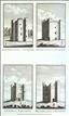
County Louth - The Castles of Killincool, Darver, Haynestown and Milltown . The Antiquities of England and Wales was the product of Alexander Hogg who was well known as a partwork publisher. Under the claimed authorship of Henry Boswell it was issued serially from c1787-9, and subsequently made available as a complete work. The format was typically 2 (though sometimes up to 6) prints to a page, with one or two accompanying pages of descriptive text on each pair of subjects. It also included the set of English county maps by Thomas Kitchin first used in the London Magazine from 1747-54. Despite being Ireland's smallest county, Louth is home to an inordinate number of historic castles, of which 4 are illustrated in this print. Many of these were of Norman foundation in the years following the Norman invasion of 1169, though others were of later medieval date. All are suggestive of the dangers of living at the northern extremity of the Pale - the coastal strip under the control of the English crown - with Gaelic Lords to the west within easy raiding distance. This print is supplied with the original, accompanying text.
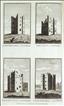
County Louth - The Castles of Roodstown, Torfecken, Town and Castletown. The Antiquities of England and Wales was the product of Alexander Hogg who was well known as a partwork publisher. Under the claimed authorship of Henry Boswell it was issued serially from c1787-9, and subsequently made available as a complete work. The format was typically 2 (though sometimes up to 6) prints to a page, with one or two accompanying pages of descriptive text on each pair of subjects. It also included the set of English county maps by Thomas Kitchin first used in the London Magazine from 1747-54. Despite being Ireland's smallest county, Louth is home to an inordinate number of historic castles, of which 4 are illustrated in this print. Many of these were of Norman foundation in the years following the Norman invasion of 1169, though others were of later medieval date. All are suggestive of the dangers of living at the northern extremity of the Pale - the coastal strip under the control of the English crown - with Gaelic Lords to the west within easy raiding distance. This print, engraved by Eastgate, is supplied with the original, accompanying text.

County Louth - The Castles of Dungooly, Roche, Ballrichan and Rath. The Antiquities of England and Wales was the product of Alexander Hogg who was well known as a partwork publisher. Under the claimed authorship of Henry Boswell it was issued serially from c1787-9, and subsequently made available as a complete work. The format was typically 2 (though sometimes up to 6) prints to a page, with one or two accompanying pages of descriptive text on each pair of subjects. It also included the set of English county maps by Thomas Kitchin first used in the London Magazine from 1747-54. Despite being Ireland's smallest county, Louth is home to an inordinate number of historic castles, of which 4 are illustrated in this print. Many of these were of Norman foundation in the years following the Norman invasion of 1169, though others were of later medieval date. All are suggestive of the dangers of living at the northern extremity of the Pale - the coastal strip under the control of the English crown - with Gaelic Lords to the west within easy raiding distance. This print, engraved by Eastgate, is supplied with the original, accompanying text.

County Louth - Carlingford Castle. The Antiquities of England and Wales was the product of Alexander Hogg who was well known as a partwork publisher. Under the claimed authorship of Henry Boswell it was issued serially from c1787-9, and subsequently made available as a complete work. The format was typically 2 (though sometimes up to 6) prints to a page, with one or two accompanying pages of descriptive text on each pair of subjects. It also included the set of English county maps by Thomas Kitchin first used in the London Magazine from 1747-54. Carlingford Castle - often called King John's Castle after a visit by the king in 1210 - was built by the Norman Hugh de Lacy probably around 1186. There were alterations and additions in the 15th and 16th centuries. The castle is located on the southern shore of Carlingford Lough, and the town grew up around it. By 1690 both town and castle had been severely mauled in the Irish rebellion of 1641 and the Jacobite-Williamsite war of 1688-91, after which the castle seems to have decayed and been abandoned. Its impressive ruins remain, though closed to the public for fear of falling masonry. This print, engraved by Barclay, is supplied with the original, accompanying text.