R. Morden Fifty Six New and Accurate Maps of Great Britain, Ireland and Wales or Magna Britannia et Hibernia 1708-1739 (1701)
Morden's set of smaller maps may originally have been drawn and engraved for Camden's Britannia, but rejected as too small. They were first published in 1701 in The New Description and State of England, with a second edition in 1704. Subsequently the printing plates were amended by Herman Moll (e.g. compass roses, and some additional place names and roads were added) and the maps re-issued in 1708 under the title Fifty Six New and Accurate Maps of Great Britain, Ireland and Wales. The maps were further issued between 1708 and 1739 under the title Magna Britannia et Hibernia. This copy of the Somerset map dates between 1726 and 1739.
T. Kitchin The Antiquities of England and Wales c1789 (1749)
This map was first published in the May 1749 edition of the London Magazine, which between 1747 and 1754 issued a complete set of English county maps by Thomas Kitchin. The maps were later re-published by Alexander Hogg in Boswell's Antiquities of England & Wales, initially in partwork from c 1787-9, and then in several complete editions of the work up to 1798. This example of the Somerset map is from the first complete edition of Boswell's Antiquities dating from c1789.
J. Ellis Ellis's English Atlas 1766 (1765)
Joseph Ellis's English Atlas was an entry into the market for small county atlases by its publishers Robert Sayer and Carington Bowles. The county maps were closely based upon those drawn by Thomas Kitchin for the 1763 topographical work England Illustrated, the major difference being the attractive vignettes which replaced Kitchin's rococco cartouches. The atlas was first published in 1765, and soon became a commercial success, running to many later editions. It was promoted as a travelling atlas, and made available in various formats. These included a version with the maps printed back to back on each page, as with this example from a 1766 edition which has a map of Shropshire on the reverse.
J. Lodge Untitled Atlas of the English Counties c1795
This was one of a set of county maps engraved by John Lodge and issued between 1787 and 1790 in The Political Magazine, and Parliamentary, Naval, Military and Literary Journal, published initially by John Murray, and later by R. Butters. The maps were subsequently collected together and re-issued as an atlas (without title page) around 1795. For this atlas edition the imprint with the publication date and engraver's and publisher's signatures was removed from the maps. This example is from the atlas edition. The maps are well engraved in the plainer style then coming into vogue. They are uncommon, and sought by collectors.
B. Capper Topographical Dictionary of the UK 1808
Benjamin Pitts Capper was the author of this topographical directory, first published by R. Phillips in 1808. The maps were engraved, and possibly drawn by H. Cooper. Later editions of the work carry the imprint of G.and W.B. Whittaker who re-published the book from 1825-34. This example is from the first edition of 1808, with the hundreds shown in original, full wash colour.
J. Cary New English Atlas 1811 (1809)
It is suprising that Cary's large county atlas was issued as late as 1809, as individual maps from it seem to have been sold singly from 1801. The atlas format was perhaps to compete with the similarly sized atlas of Charles Smith, which went under the same title and was published in 1804. It is perhaps Cary's finest production, the maps being notable for their fine design, detail and engraving. The atlas ran to several later editions by Cary, and the plates were later used for a variety of lithographic transfers by G.F. Cruchley. This example is from the second edition of 1811, and is in original full colour.
J. Cary A New Map of Somerset Divided into Hundreds 1811 (c1801)
Cary's large county maps were first issued individually from about 1801, before being collected into atlas format in 1809 under the title Cary's New English Atlas. There was a second edition of the atlas in 1811, for which the imprints on the maps were re-dated. The maps continued to be sold individually, and this example is dated 1811. It is dissected and linen-backed and folds into card covers, although it is missing the original slipcase. Original full-wash colour. it bears the signature of (probably) the original owner in the top-left corner.
A. Fullarton The Parliamentary Gazetteer of England and Wales 1847 (1833)
These maps were first published by Fullarton and Co. in 1833 in James Bell's New and Comprehensive Gazetteer of England and Wales which was re-issued three times in the 1830's. They were subsequently re-published (again by Fullarton) in 1840 in The Parliamentary Gazetteer of England and Wales, with several further re-issues up to 1849. The maps were engraved on steel and sometimes bear the name of the engraver and sometimes not. This example is from the Parliamentary Gazetteer of 1847 and lacks an engraver's signature.
Thomas Moule's antiquarian leanings are evident in this series of highly decorative county maps - a stylistic throwback in an age when cartographic work had become much plainer and more utilitarian. The maps were engraved by W. Smollinger, J. Bingley and J. Dower, and first appeared in Moule's English Counties Delineated, a partwork with text issued from 1830-32. They were subsequently made available as a complete work in 1837 under the same title, and were later re-issued in Barclay's Universal English Dictionary between 1842 and 1852. This latter work ran to several editions and the maps were often updated between editions to show the latest growth of the railway network. This example in modern colour is from the 1852 edition of Barclay's Dictionary. Supplied mounted and ready for framing.
Original colour in good condition. In c1849 maps from the Walkers' British Atlas were used for this new publication for the hunting enthusiast. The maps were overprinted and coloured to show the territories of the various hunts.The Atlas continued into the 1880's (later editions being titled "Walkers Fox-hunting Atlas" This example is believed to be an early one.
A. Perrot L'Angleterre ou Description Historique et Topographique 1824, 1828 or 1835 (1824)
The text for this French topographical work on Britain was written by George Depping, the maps being drawn by Aristide Perrot and engraved by A. Migneret. It was first published in 1824, with subsequent editions in 1828 and 1835. The maps often cover more than one county as in this example which also includes Dorset. The surrounding decorative border shows the typical produce and wares of the counties. Original outline colour. A few small, light-brown spots. Supplied mounted.
These maps (without the decorative borders) were first issued in 1821 in Miller's New Miniature Atlas. The plates were later acquired by William Darton who re-issued them as a miniature atlas, but also used the maps, now further embellished by country scenes, in this children's work. Reuben Ramble is an invented character. Original colour to the illustrations.
The Walker's British Atlas was first issued in 1837, and ran to many subsequent editions with frequent updates to railways and other information. This example is from the editions of 1854 or 1856 - so dated from the railways shown, the publisher's imprints, and the population figures quoted. Full wash colour.
Jan Jansson was one of Amsterdam's leading 17th century mapmakers, and a close rival to the Blaeu family. His multi-volume world atlas first saw the introduction of 6 maps of individual English counties into the German edition of 1636, and a further 11 of English and Welsh counties in the Dutch edition of 1644. But when Jansson saw the 1645 Blaeu volume with more decorative maps covering all the English and Welsh counties, he felt obliged to revise his existing plates and complete the set in order to compete. His new volume covering England and Wales was first published in the 1646 Latin text edition of the Atlas Novus. There were several later editions by Jansson, and later issues by Schenk and Valk who acquired the plates in 1694. This example bears the Schenk and Valck imprint, and has a graticule of latitude and longitude added. It is in original full colour.
The plates of Mercator's 1595 Atlas later passed to the Hondius family and then to Jan Jansson who all continued to issue new editions with changes and additions along the way. In 1636 Jansson issued a new German edition of the atlas in which a number of new maps of individual English counties appeared for the first time, including this map of Somerset (mis-spelled Somerest-shire). These maps appeared again in the 1644 Dutch edition, but were subsequently revised with the addition of coats of arms and other decorative flourishes to better compete with the British maps in Vol 4 of Blaeu's 1645 Theatrum Orbis Terrarum. The revised versions were then re-published in Jansson's Atlas Novus of 1646.This first-state version of Somerset is not common, and would be a welcome addition to any Somerset collection.
James Wallis's New British Atlas was first published in 1813 by S.A. Oddy. There was a second edition in 1816. This example is from the first edition and is dated 1812 on the imprint. It is in attractive, original, full wash colour, and in good condition.
Langley's county atlas was first published in 1818 by Edward Langley and William Belch, who were in partnership from 1807-1820. This example is from the second edition of the atlas published by Joseph Phelps in 1820, shortly after the dissolution of the partnership. Phelps name now appears on the imprint in place of the original partners, but the atlas title is still attributed to Langley. The maps from the work are attractive, with topograhical vignettes (in this case St. Vincent's Rock and Hot Wells, Bristol), and usually found in original full wash colour.
This work was published in 1835 as a companion volume to Lewis's Topographic Dictionary. It contains county and borough maps, drawn by R. Creighton and engaved by J.& C. Walker, and was designed to show the electoral and boundary changes effected by the 1832 Reform Act. There were 2 issues of the work in 1835 and 1840, this example of the county map being from the 1835 first edition. Original outline colour.
This detailed and well engraved map was one of a set first published around 1812-14 by Robert Rowe, who was probably also their draftsman and engraver. The maps were initially sold singly in folding format until their collective issue in 1816 as The English Atlas. The plates were later acquired by Henry Teesdale, who amended titles and imprints and re-issued the work as the New British Atlas in 1829, with several re-issues up to 1842. The plates were later acquired and used by H.G. Collins and then by G. Philip and Son, who both used them as the base for lithographic transfers for a variety of works up to c1860. This example is from the 1830 second edition of Teesdale's atlas. Original wash colour. A couple of marginal, repaired tears, not affecting the printed image.
C. Smith New English Atlas (reduced maps) 1828 or 1833 (1822)
In 1822 Charles Smith issued a county atlas with maps based on his larger county maps which had been in circulation for over 20 years. The new maps were smaller in scale, but the atlas bore the same title as that in which his larger maps appeared. They are clearly drawn and engraved, but although there were several editions of the atlas, they are today amongst the rarer of the 18th century county maps. This example is from the edition of 1828 or 1833, in which the maps have no date in the imprint, but before railways were added for the edition of 1844. Original outline colour.
The City of Bath. The New British Traveller was one of a number of publications by Alexander Hogg aiming to tap the bouyant market for works on British topography and antiquities. It included text on each couny, a set of county maps by T. Conder and others, and numerous copperplate prints by a variety of engravers. The work was initially issued in 60 parts from c1783, and then as a complete work from 1784. Bath was a well known spa town in Roman times, and the original Roman baths still survive. It regained its reputation as a Spa resort in the late 17th century, and was further developed as such by the Georgians, with many of the city's iconic building being constructed in the 18th century, giving Bath an architectural integrity which justifies its status as a World Heritage Site. This print has been remargined to the lower border, where separated from an adjoining view on the same page. A little marginal foxing, which would be mostly hidden by a mount.

Chapel of St. Joseph of Arimithea, Glastonbury Abbey. The Antiquities of England and Wales was the product of Alexander Hogg who was well known as a partwork publisher. Under the claimed authorship of Henry Boswell it was issued serially from c1787-9, and subsequently made available as a complete work. The format was typically 2 (though sometimes up to 6) prints to a page, with one or two accompanying pages of descriptive text on each pair of subjects. It also included the set of English county maps by Thomas Kitchin first used in the London Magazine from 1747-54. The Chapel of St. Joseph is part of the surviving ruins of Glastonbury Abbey. According to one tradition, the Abbey was founded in the 1st century AD by Joseph of Arimethea, but in actuality its first foundation dates from the 7th century AD. The old monastery was mostly destroyed by fire in 1184, but reconstruction began immediately afterwards, and the Abbey grew into one of richest in the country. After the dissolution of the monasteries, it passed into private ownership, and the site was robbed of much of its stone. The surviving ruins are today owned by Glastonbury Abbey Trust, and open to the public. This print, engraved by Noble, is supplied with the original, accompanying text from the work. A few spots to the margins.
Glastonbury Abbey. The Antiquities of England and Wales was the product of Alexander Hogg who was well known as a partwork publisher. Under the claimed authorship of Henry Boswell it was issued serially from c1787-9, and subsequently made available as a complete work. The format was typically 2 (though sometimes up to 6) prints to a page, with one or two accompanying pages of descriptive text on each pair of subjects. It also included the set of English county maps by Thomas Kitchin first used in the London Magazine from 1747-54. According to one tradition, Glastonbury Abbey was founded in the 1st century AD by Joseph of Arimethea, but in actuality its first foundation dates from the 7th century AD. The old monastery was mostly destroyed by fire in 1184, but reconstruction began immediately afterwards, and the Abbey grew into one of richest in the country. After the dissolution of the monasteries, it passed into private ownership, and the site was robbed of much of its stone. The surviving ruins are today owned by Glastonbury Abbey Trust, and open to the public. This print, engraved by Noble, offers 2 views on one sheet, and is supplied with the original, accompanying text from the work.
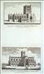
The Cathedral Churches of Bath and Bristol. The Antiquities of England and Wales was the product of Alexander Hogg who was well known as a partwork publisher. Under the claimed authorship of Henry Boswell it was issued serially from c1787-9, and subsequently made available as a complete work. The format was typically 2 (though sometimes up to 6) prints to a page, with one or two accompanying pages of descriptive text on each pair of subjects. It also included the set of English county maps by Thomas Kitchin first used in the London Magazine from 1747-54. The "so-called" Cathedral Church of Bath is now a misnomer. Bath Abbey is today the Parish Church. It was formerly the church of a Benedictine Abbey, raised to cathedral status in 1090 when the Bishop transferred his seat from Wells. The existingl Abbey church was subsequently much rebuilt. In 1245 status disputes between Wells and Bath were resolved by the Pope, who gave them joint status, though Wells became the Bishop's seat once again, but after the dissolution of the monasteries, much of Bath Abbey was demolished apart from part of the nave which became the Parish Church. This print, engraved by Thornton, offers 2 views on 1 sheet and is supplied with the original accompanying text from the work.

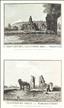
Farley Castle, Burrough Chaper, Cleve Abbey (all Somerset), Pevensey Castle & Winchelsea Monastery (Sussex) & Wenlock Priory (Shropshire). The Antiquities of England and Wales was the product of Alexander Hogg who was well known as a partwork publisher. Under the claimed authorship of Henry Boswell it was issued serially from c1787-9, and subsequently made available as a complete work. The format was typically 2 (though sometimes up to 6) prints to a page, with one or two accompanying pages of descriptive text on each pair of subjects. It also included the set of English county maps by Thomas Kitchin first used in the London Magazine from 1747-54. This print offers 6 views on one page, of which 3 are of Somerset interest. Farley (or Farleigh-Hungerford) Castle dates from the 14th century, and was the seat of the Hungerford family. it was sold in 1686 and fell into disrepair. Since 1915 it has been in State ownership, and is now managed by English Heritage and open to the public. Cleve Abbey is a Cistercian foundation of 1191. After the dissolution of the monasteries it bacame a private house, and later was used as farm buildings. Its ruins are today also maintained by English Heritage with public access. The print is supplied with the original accompanying text.
Bristol - The Terminus of the Great Western Railway. The British Gazetteer was authored by B. Clarke and published by H.G. Collins in 1852. Apart from topographical text listings, it included a set of county maps (originally by Rowe), and a small series of railway prints after drawings by J.F. Burrell. This print was engraved by A. Ashley after a drawing by J.F. Burrell, and shows the frontage of Temple Meads Station. The station was designed and built by Isambard Kingdom Brunel, initially for the Great Western Railway, but was soon being used by several additional railway companies, requiring its expansion and provision for "through" services in the 1870's. It was further expanded in the 1930's. Brunel's original station was taken out of service in 1965, but is Grade 1 Listed and still used for other purposes. The print has some waterstaining.
Author not known. Pictureque Europe c1876/7
The George, Glastonbury. Picturesque Europe was a serialised partwork, designed as a showcase for steel and wood engravings after and by significant artists of the day. The 60 parts were published monthly from 1875 to 1880.When sets of parts were completed, they were also sold as complete volumes, building to a full 5-volume set, 2 volumes of which were devoted to the British Isles.This wood-cut print, engraved by Whymper after P. Skelton, shows The George, a classical old coaching inn on Glastonbury's High Street, and appeared in part 14 of the work. The Inn, which dates back to the 1400's, is today named the George and Pilgrim Hotel.