J. Speed Theatre of the Empire of Great Britaine 1676 (1612)
John Speed's maps of the English and Welsh counties are amongst the most decorative of early, British cartographic work, and are eagerly sought after today. They were first published in 1612 in The Theatre of the Empire of Great Britaine, designed as a companion volume to Speed's History of Great Britaine. The maps were based on the earlier surveys of Saxton, Norden and a few others, with engraving contracted to Jodocus Hondius whose signature appears on 33 of the maps. Speed's greatest innovation was the inclusion of inset plans of major towns and cities. Although some were copied from earlier work, for many towns this was first plan ever published. Speed's county atlas was re-issued a number of times for a period of around 160 years, with new publishers making various small changes and updates to the maps over time. This example bears the imprint of Basset & Chiswell, dating it to the edition of 1676. A most attractive map based on John Norden's original work.
J. Blaeu Atlas Mayor 1659 or 1662 (1645)
The Blaeu family were one of the leading Dutch map producers of the 17th century. Their major work was a multi volume world atlas initiated by Willem Blaeu and expanded by his son Joan. Their maps were beautifully designed and engraved, and are often found with original colour, making them most desirable to collectors. 1645 saw the first publication of volume 4 of the atlas, containing maps of England and Wales. There were several re-issues between then and 1672 when most of Blaeu's plates were lost in a fire which engulfed his Amsterdam premises. Spanish text on verso dates this example to the 1659 or 1662 editions. Original full colour. Repaired top and bottom centrefold tears but well outside the printed area.
The Agreeable Historian was a weekly partwork, intended to be bound into 3 volumes when completed. It was issued in 109 parts beween December 1743 and December 1745, with the final title page being dated 1746. The work was a topographical review of the counties of England, being published by R. Walker, with Samuel Simpson cited as the author.
This small county atlas of England and Wales was first issued in 1748 by a consortium of 7 publishers who also had a stake in the publication of Daniel Defoe's Tour Through the Whole Island of Great Britain. It was advertised as a companion volume to Defoe's work, or as a pocket atlas in its own right. Thomas Hutchinson's name appears as the engraver on 2 maps, but the rest are unsigned and may be by a variety of hands. They are sometimes also known as Osborne/Wale maps. There was a second edition in 1756. A short tear repaired on the verso without loss. Mounted.
J. Cary New and Correct English Atlas 1809 (1787)
The last decades of the 18th century saw less emphasis being placed on the traditions of decorative mapmaking in favour of a plainer style and design. Foremost amongst this new wave of "modern" cartographers and engravers was John Cary. The New and Correct English Atlas was Cary's first major production as a publisher in his own account. The maps were not only clearly and elegantly drawn and engraved, but also set new standards in accuracy in taking advantage of all the new large-scale county surveys of the second half of the 18th century. The atlas was first published in 1787, with a re-issue in 1793. By 1808 the plates were well worn, and the engraving of a new set was begun. The next dated edition of 1809, from which this example comes, utilised these new plates. Original outline colour.
J. Cary New English Atlas 1811 (1809)
It is suprising that Cary's large county atlas was issued as late as 1809, as individual maps from it seem to have been sold singly from 1801. The atlas format was perhaps to compete with the similarly sized atlas of Charles Smith, which went under the same title and was published in 1804. It is perhaps Cary's finest production, the maps being notable for their fine design, detail and engraving. The atlas ran to several later editions by Cary, and the plates were later used for a variety of lithographic transfers by G.F. Cruchley. This example is from the second edition of 1811, and is in original full colour. A vertical crease, and some repaired tears at lower centrefold.
James Pigot & Co's county maps were issued in their British Atlas (from c1830), in several of their national and local business directories (from at least 1826 for the "home counties", including Sussex), and singly in folding form as travelling maps. They were amongst the first maps to be printed from steel instead of copper plates, allowing more accurate fine detail and less wear to the plates over time. Atlas and directories went through several editions up to around 1857, later editions from 1846 being re-named Slater's New British Atlas, with imprints changed accordingly. This example is from the first atlas edition of c1829. Original outline colour. A slight crease.
Thomas Moule's antiquarian leanings are evident in this series of highly decorative county maps - a stylistic throwback in an age when cartographic work had become much plainer and more utilitarian. The maps were engraved by W. Smollinger, J. Bingley and J. Dower, and first appeared in Moule's English Counties Delineated, a partwork with text issued from 1830-32. They were subsequently made available as a complete work in 1837 under the same title, and were later re-issued in Barclay's Universal English Dictionary between 1842 and 1852. This latter work ran to several editions and the maps were often updated between editions to show the latest growth of the railway network. This example in modern colour can be dated by railway information to the 1844 or 1845 editions of Barclay's Dictionary. Supplied mounted and ready for framing.
J. Lodge Untitled Atlas of the English Counties c1795
This was one of a set of county maps engraved by John Lodge and issued between 1787 and 1790 in The Political Magazine, and Parliamentary, Naval, Military and Literary Journal, published initially by John Murray, and later by R. Butters. The maps were subsequently collected together and re-issued as an atlas (without title page) around 1795. For this atlas edition the imprint with the publication date and engraver's and publisher's signatures was removed from the maps. This example is from the atlas edition. The maps are well engraved in the plainer style then coming into vogue. They are uncommon, and sought by collectors.
This work was published in 1835 as a companion volume to Lewis's Topographic Dictionary. It contains county and borough maps, drawn by R. Creighton and engaved by J.& C. Walker, and was designed to show the electoral and boundary changes effected by the 1832 Reform Act. There were 2 issues of the work in 1835 and 1840, this example of the county map being from the 1835 first edition. Original outline colour.
This detailed and well engraved map was one of a set first published around 1812-14 by Robert Rowe, who was probably also their draftsman and engraver. The maps were initially sold singly in folding format until their collective issue in 1816 as The English Atlas. The plates were later acquired by Henry Teesdale, who amended titles and imprints and re-issued the work as the New British Atlas in 1829, with several re-issues up to 1842. The plates were later acquired and used by H.G. Collins and then by G. Philip and Son, who both used them as the base for lithographic transfers for a variety of works up to c1860. This example is from the 1830 second edition of Teesdale's atlas. Original wash colour. One repaired tear entering the lower border by c1.5cm.


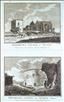
Brighton from the sea & Chichester. The New British Traveller was one of a number of publications by Alexander Hogg aiming to tap the bouyant market for works on British topography and antiquities. It included text on each couny, a set of county maps by T. Conder and others, and numerous copperplate prints by a variety of engravers. The work was initially issued in 60 parts from c1783, and then as a complete work from 1784. Brighton (or Brighthelmstone as it was once called), was a small settlement at the time of Domesday Book, and remained a fishing village until its development in the 18th and 19th centuries into a fashionable seaside resort.This was helped by its patronage by the Prince Regent, the future George IV, who first visited in 1783, and later built his Royal Pavillion there in the 1820's. Chichester was an important Roman town, which became a Bishop's seat in 1075, and its cathedral - shown in this print - dates from that time. This print has a narrow righ-hand margin, but sufficient for mounting.

Arundel Castle & Lord George Lenox's seat at West Stoke. The New British Traveller was one of a number of publications by Alexander Hogg aiming to tap the bouyant market for works on British topography and antiquities. It included text on each couny, a set of county maps by T. Conder and others, and numerous copperplate prints by a variety of engravers. The work was initially issued in 60 parts from c1783, and then as a complete work from 1784. The construction of Arundel Castle was begun in 1067 by Roger de Montgomery. It guards the Arun gap through the South Downs, and has been owned by the Howard family, Dukes of Norfolk, since 1557. In the 18th and 19th centuries it was remodelled as a comfortable stately home, and is today open to the public. Lord George Lennox made his reputation as a soldier, but was also an MP, representing the constituencies of Chichester, and later Sussex betwenn 1761 and 1790. His house at West Stoke, 4 miles from Chichester, still survives as a private residence.The print has a few spots to the margins, which would be hidden by a mount.
Winchelsea Church and Winchelsea Castle. The Antiquities of England and Wales was the product of Alexander Hogg who was well known as a partwork publisher. Under the claimed authorship of Henry Boswell it was issued serially from c1787-9, and subsequently made available as a complete work. The format was typically 2 (though sometimes up to 6) prints to a page, with one or two accompanying pages of descriptive text on each pair of subjects. It also included the set of English county maps by Thomas Kitchin first used in the London Magazine from 1747-54. Old Winchelsea was a thriving port, dating from Saxon times, which was lost to encroachment by the sea in 1287. King Edward I founded a new town to replace it in 1288 and today's Parish Church of St. Thomas incorporates as its nave the Chancel of the original 13th century church. The ruins of the transepts of the old church stand in the churchyard. The church was possibly destoyed or damaged in French riads in the medieval period, but may also have been reduced in size to cater for a smaller congregation as the town decayed when its harbour silted up. A free-standing tower in the churchyard may have benn a watchtower. It was demolished in 1790, but can be seen in old prints. Winchelsea had fortified town walls and 4 gates, but never had a castle. The castle here mis-named is actually Camber Castle built in 2 stages from 1512-14 and 1539-55 to protect the port of Rye. Camber Castle is only just over 1mile from both Winchelsea and Rye. It is today maintained by English Heritage and open to the public. This print, engraved by Page, offers 2 views on one sheet, and is supplied with the original, accompanying text.

Winchelsea Castle. The Antiquities of England and Wales was the product of Alexander Hogg who was well known as a partwork publisher. Under the claimed authorship of Henry Boswell it was issued serially from c1787-9, and subsequently made available as a complete work. The format was typically 2 (though sometimes up to 6) prints to a page, with one or two accompanying pages of descriptive text on each pair of subjects. It also included the set of English county maps by Thomas Kitchin first used in the London Magazine from 1747-54. Old Winchelsea was a thriving port, dating from Saxon times, which was lost to encroachment by the sea in 1287. King Edward I founded a new town to replace it in 1288. New Winchelsea had fortified town walls and 4 gates, but never had a castle. The castle here mis-named is actually Camber Castle built in 2 stages from 1512-14 and 1539-55 to protect the port of Rye. Camber Castle is only just over 1mile from both Winchelsea and Rye. It is today maintained by English Heritage and open to the public. This print is engraved by Sparrow.
Shelbred Priory (near Linchmere). The Antiquities of England and Wales was the product of Alexander Hogg who was well known as a partwork publisher. Under the claimed authorship of Henry Boswell it was issued serially from c1787-9, and subsequently made available as a complete work. The format was typically 2 (though sometimes up to 6) prints to a page, with one or two accompanying pages of descriptive text on each pair of subjects. It also included the set of English county maps by Thomas Kitchin first used in the London Magazine from 1747-54. Shelbred (or Shulbrede) Abbey was a small Augustinian Priory founded around 1190 by Ralph de Ardene, with a Prior and 5 Canons. At the dissolution the site passed into private hands. The surviving ruins are today incorporated into a private house. This print was engraved by Sparrow.
Boxgrove Priory (near Chichester). The Antiquities of England and Wales was the product of Alexander Hogg who was well known as a partwork publisher. Under the claimed authorship of Henry Boswell it was issued serially from c1787-9, and subsequently made available as a complete work. The format was typically 2 (though sometimes up to 6) prints to a page, with one or two accompanying pages of descriptive text on each pair of subjects. It also included the set of English county maps by Thomas Kitchin first used in the London Magazine from 1747-54. Boxgrove Priory was a Benedictine house founded by Robert de Haye around 1066. After the dissolution of the monasteries the Priory church was retained to serve the parish, as it still does today. Other ruins of the Priory, including its hospitium or guest house, are under the care of English Heritage with free access to the public. This print, engraved by Thornton, is supplied with the original, accompanying text.
Battle Abbey. The Antiquities of England and Wales was the product of Alexander Hogg who was well known as a partwork publisher. Under the claimed authorship of Henry Boswell it was issued serially from c1787-9, and subsequently made available as a complete work. The format was typically 2 (though sometimes up to 6) prints to a page, with one or two accompanying pages of descriptive text on each pair of subjects. It also included the set of English county maps by Thomas Kitchin first used in the London Magazine from 1747-54. Battle Abbey was built between 1070 and 1094 on the site of the Battle of Hastings. After the dissolution of the monasteriespart of the site became a private house, other parts being robbed for their stone. Some surviving ruins today form part of Battle Abbey School. Other parts are maintained by English Heritage and open to the public. This print was engraved by Thornton.
Lewes Priory. The Antiquities of England and Wales was the product of Alexander Hogg who was well known as a partwork publisher. Under the claimed authorship of Henry Boswell it was issued serially from c1787-9, and subsequently made available as a complete work. The format was typically 2 (though sometimes up to 6) prints to a page, with one or two accompanying pages of descriptive text on each pair of subjects. It also included the set of English county maps by Thomas Kitchin first used in the London Magazine from 1747-54. Lewes Priory was a Cluniac house to the south of Lewes in the Ouse Valley. It was founded in c1081, and mostly demolished after the dissolution of the monasteries. Some remains still survive in public grounds owned by Lewes Town Council, and managed by a local Trust with free access. This print, engraved by Page, offers 2 views on 1 sheet, and is supplied with the original, accompanying text

Lewes Castle. The Antiquities of England and Wales was the product of Alexander Hogg who was well known as a partwork publisher. Under the claimed authorship of Henry Boswell it was issued serially from c1787-9, and subsequently made available as a complete work. The format was typically 2 (though sometimes up to 6) prints to a page, with one or two accompanying pages of descriptive text on each pair of subjects. It also included the set of English county maps by Thomas Kitchin first used in the London Magazine from 1747-54. Lewes Castle was built by William de Warenne around 1069, originally in wood but later refortified in stone. In stands in a central location on the town's High Street, and later passed into the ownership of the local Fitzalan family, Earls of Arundel. It still stands today, with the majority of the site owned by the Sussex Archaeological Society who open it to the public. There are some private houses within the precincts. This print was engraved by Sparrow, and is supplied with the original, accompanying text.

The Block House, Brighton. The Antiquities of England and Wales was the product of Alexander Hogg who was well known as a partwork publisher. Under the claimed authorship of Henry Boswell it was issued serially from c1787-9, and subsequently made available as a complete work. The format was typically 2 (though sometimes up to 6) prints to a page, with one or two accompanying pages of descriptive text on each pair of subjects. It also included the set of English county maps by Thomas Kitchin first used in the London Magazine from 1747-54. After two attacks by the French in the 1500's the inhabitants of Brighton secured permission and land in 1558 to build the small town's first fortifications. These were centred upon the Blockhouse, a storhouse for arms and gunpowder for their canons. The Blockhouse stood on the edge of the cliffs near the southern end of today's Middle Street. Coastal erosion of the cliffs led to the collapse of the Blockhouse in 1748, leaving ruins for the pencils of 18th century artists. This print, engraved by Hawkins, is supplied with the original, accompanying text.
Arundel Castle . The Antiquities of England and Wales was the product of Alexander Hogg who was well known as a partwork publisher. Under the claimed authorship of Henry Boswell it was issued serially from c1787-9, and subsequently made available as a complete work. The format was typically 2 (though sometimes up to 6) prints to a page, with one or two accompanying pages of descriptive text on each pair of subjects. It also included the set of English county maps by Thomas Kitchin first used in the London Magazine from 1747-54. The construction of Arundel Castle was begun in 1067 by Roger de Montgomery. It guards the Arun gap through the South Downs, and has been owned by the Howard family, Dukes of Norfolk, since 1557. In the 18th and 19th centuries it was remodelled as a comfortable stately home, and is today open to the public. This print was engraved by Page, and is supplied with the original, acoompanying text.

Hastings Castle. The Antiquities of England and Wales was the product of Alexander Hogg who was well known as a partwork publisher. Under the claimed authorship of Henry Boswell it was issued serially from c1787-9, and subsequently made available as a complete work. The format was typically 2 (though sometimes up to 6) prints to a page, with one or two accompanying pages of descriptive text on each pair of subjects. It also included the set of English county maps by Thomas Kitchin first used in the London Magazine from 1747-54. Hastings Castle was constructed immediately after the Battle of Hastings on the orders of William the Conqueror, to secure his beach-head and provide a safe harbour. The first fortifications were of wood, but rebuilt in stone in 1070. The castle was built on cliffs overlooking the sea and the town, but erosion in the 13th and 14th centuries resulted in the loss of parts of the complex, and it was eventually abandoned to decay from the 16th century. In 1851 the surviving ruins were bought by Hastings Corporation, who open them as a tourist attraction today. This print, engraved by Page, is supplied with the original, accompanying text.
Chichester Cathedral. The Antiquities of England and Wales was the product of Alexander Hogg who was well known as a partwork publisher. Under the claimed authorship of Henry Boswell it was issued serially from c1787-9, and subsequently made available as a complete work. The format was typically 2 (though sometimes up to 6) prints to a page, with one or two accompanying pages of descriptive text on each pair of subjects. It also included the set of English county maps by Thomas Kitchin first used in the London Magazine from 1747-54. Chichester was an important Roman town, which became a Bishop's seat in 1075, and its cathedral - shown in this print - dates from that time. Its architecture is a mixture of the Norman and Gothic styles, and It is unusual in having a separate bell tower and double aisles. This print, engraved by Thornton, is supplied with the original, accompanying text.
Aldridge Rectory, near Brighton. The Antiquities of England and Wales was the product of Alexander Hogg who was well known as a partwork publisher. Under the claimed authorship of Henry Boswell it was issued serially from c1787-9, and subsequently made available as a complete work. The format was typically 2 (though sometimes up to 6) prints to a page, with one or two accompanying pages of descriptive text on each pair of subjects. It also included the set of English county maps by Thomas Kitchin first used in the London Magazine from 1747-54. My internet searches have failed to provide any information on any historic rectory in Aldridge, Brighton. This print was engraved by Sparrow.

Converted Priory at Apuldram, near Chichester. The Antiquities of England and Wales was the product of Alexander Hogg who was well known as a partwork publisher. Under the claimed authorship of Henry Boswell it was issued serially from c1787-9, and subsequently made available as a complete work. The format was typically 2 (though sometimes up to 6) prints to a page, with one or two accompanying pages of descriptive text on each pair of subjects. It also included the set of English county maps by Thomas Kitchin first used in the London Magazine from 1747-54. Apledram is a small settlement near Chichester Harbour, about 2 miles south-west of Chichester. Internet searches have failed to provide much information on the existence of a Priory in the village, the only such mention being a suggestion in 18th century sources that the parish church of St. Mary began life as a priory, though this is not supported by modern sources. The church dates from the 12th century, but was substantially rebuilt around the middle of the 13th century. This print was engraved by Sparrow, and is supplied with the original, accompanying text.

Dudeney Chapel in Ashford Forest. The Antiquities of England and Wales was the product of Alexander Hogg who was well known as a partwork publisher. Under the claimed authorship of Henry Boswell it was issued serially from c1787-9, and subsequently made available as a complete work. The format was typically 2 (though sometimes up to 6) prints to a page, with one or two accompanying pages of descriptive text on each pair of subjects. It also included the set of English county maps by Thomas Kitchin first used in the London Magazine from 1747-54. The origins of Dudeney Chapel are shrouded in mystery. The accompanying text to this print says the chapel is "in the Forest of Ashdown", but there is today no settlement by this name, and no known ruins that fit the bill. The Reverend Edward Turner, writing in 1857, offered two suggestions - that the Chapel might be confused with he Chapel of Maresfield (no longer extant), or that it might be explained by some recent old foundations discovered at Duddleswell. No modern conclusion seems to have been reached. The print, engraved by Sparrow, is supplied with the original, accompanying text.
Author not known. Picturesque Europe c1875
Bodiam Castle. Picturesque Europe was a serialised partwork, designed as a showcase for steel and wood engravings after and by significant artists of the day. The 60 parts were published monthly from 1875 to 1880.When sets of parts were completed, they were also sold as complete volumes, building to a full 5-volume set, 2 volumes of which were devoted to the British Isles.This wood-cut print, engraved by J.W. Whymper, shows Bodiam Castle, and appeared in Part 4 of the work. Between 1385 and 1389 Richard II gave license" to crennelate" to Edward Dalngrigge, Lord of the Manor of Bodiam.Rather than fortify his existing manor house, he built Bodiam Castle on a new site. The property passed through the hands of several later owners, by marriage or by sale, and after partilal sleighting in the civil war it decayed, though still occupied, before two bouts of restoration in the mid 1800's. In 1925 it passed to the ownership of the National Trust who maintain it today, with public access.
Author not known. Picturesque Europe c1875
Hurstmonceaux Castle. Picturesque Europe was a serialised partwork, designed as a showcase for steel and wood engravings after and by significant artists of the day. The 60 parts were published monthly from 1875 to 1880.When sets of parts were completed, they were also sold as complete volumes, building to a full 5-volume set, 2 volumes of which were devoted to the British Isles.This wood-cut print has an unidentifiable author's cypher, and appeared in Part 5 of Picturesque Europe, published c1875.The construction of Hutstmonceaux Castle was begun in 1441 by Sir Roger Fiennes, on the site of an earlier manor house. By the mid 18th centry it had decayed and was partially dismantled in1777, leaving the exterior walls standing as a picturesque shell (as shown here). In the 20th centry it was, however, restored for use as a private house, and subsequently became the home of the Royal Greenwich Observatory from 1957-88. It is today owned by Queen's University, Canada, and run as The Bader International Study Centre.
Author not known. Picturesque Europe c1875
Off Beachy Head, Sussex . Picturesque Europe was a serialised partwork, designed as a showcase for steel and wood engravings after and by significant artists of the day. The 60 parts were published monthly from 1875 to 1880.When sets of parts were completed, they were also sold as complete volumes, building to a full 5-volume set, 2 volumes of which were devoted to the British Isles.This vivid wood-cut print, engraved by J.W. Whymper after a drawing by T.L. Rowbotham, shows small boats salvaging wreckage after a storm, with Beachy Head and Eastbourne as a backdrop.