R. Morden The New Description and State of England 1701 or 1704
Morden's set of smaller maps may originally have been drawn and engraved for Camden's Britannia, but rejected as too small. They were first published in 1701 in The New Description and State of England, re-issued in 1704. They were subsequently published in two further works - Fiftly Six New and Accurate Maps of Great Britain Ireland and Wales in 1708; and Magna Britannia et Hibernia, which enjoyed several editions between1714 and1731. This example is from either the first edition of The New Description and State of England in 1701, or the second of 1704. Modern colour.
R. Blome England Exactly Described 1731 (1681)
Blome's smaller series of county maps have a puzzling history. They seem to have been initiated before his larger maps for Britannia, but were not published until 1681 when they appeared under the title Speed's Maps Epitomiz'd. Blome re-issued them twice before his death in 1705, under new titles and sometimes with changed dedications (as was the case with the Surrey map). The plates were subsequently acquired by Thomas Taylor who brought out a new edition in 1715 titled England Exactly Described. The final issue of the work was by Thomas Bakewell in 1731. The presence of plate numbers and roads, and presence of his signature dates this example to the 1731 Bakewell edition of the work. Supplied ready-mounted.
H. Moll A New Description of England and Wales 1724
The absence of a plate number on this map suggests in emanates from the first publication of Moll's county maps together with text as A New Description of England and Wales. It was also shortly afterwards issued in atlas format, for which plate numbers were added. There were several later editions in both formats. The addition of the view of London Bridge to the Surrey map, is an interesting variation of the Roman antiquities which usually decorate the borders. Light foxing, but still an attractive copy, and priced accordingly. Mounted.
The Agreeable Historian was a weekly partwork, intended to be bound into 3 volumes when completed. It was issued in 109 parts beween December 1743 and December 1745, with the final title page being dated 1746. The work was a topographical review of the counties of England, being published by R. Walker, with Samuel Simpson cited as the author.
John Aikin (or Aiken) wrote this topographical work for children in order "to make my young countrymen better acquainted than they are usually found to be with their native land". The first edition of 1788 did not include county maps, but these were added for the second edition of 1790, from which this example comes. The work was published by Joseph Johnson, but the maps are unsigned. There were four later editions of the book with the maps, and one without. The Surrey map is fairly simple, befitting the needs of its target audience, and the text may be available at no extra charge.
B. Capper Topographical Dictionary of the UK 1808
Benjamin Pitts Capper was the author of this topographical directory, first published by R. Phillips in 1808. The maps were engraved, and possibly drawn by H. Cooper. Later editions of the work carry the imprint of G.and W.B. Whittaker who re-published the book from 1825-34. This example is from the first edition of 1808, with the hundreds shown in original, full wash colour.
C. Smith New English Atlas (reduced maps) 1828/1833 (1822)
In 1822 Charles Smith issued a county atlas with maps based on his larger county maps which had been in circulation for over 20 years. The new maps were smaller in scale, but the atlas bore the same title as that in which his larger maps appeared. They are clearly drawn and engraved, but although there were several editions of the atlas, they are today amongst the rarer of the 18th century county maps. This example is from the edition of 1828 or 1833, in which the maps have no date in the imprint, but before railways were added for the edition of 1844. Original outline colour.
T. Dix W. Darton Sold individually in card covers titled simply "Surrey" c1835 (1822)
Thomas Dix initiated this atlas project some time around 1816, but after his death it was carried on to completion by the publisher William Darton. The finished atlas (titled A Complete Atlas of the English Counties) was issued in 1822, though first editions of individual maps bear various dates between 1816 and 1821. The atlas was re-published in 1835 under a new title and with a number of changes to the maps. Around this time the maps were also offered for sale individually, dissected and linen-backed, and folding into card covers, as with this example. They are very attractive, with topographical vignettes and in original full wash colour, and are relatively scarce.
The Greenwoods surveyed all the counties from 1817-33 for their beautifully engraved county atlas finally published in 1834. Maps were also sold singly as produced. The Surrey map is corrected to 1829, and this example's centrefold suggests it was sold in atlas format. Original full wash colour. The maps has a number repairs - mostly to marginal tears, but also to one longer tear entering the left-hand border by 14cms. These have been professionally done, and strengthened by the whole map being laid down onto another matching sheet of paper. The map would still mount up and frame well, with most of these repairs then not being seen. Priced accordingly.
T. Murray An Atlas of the English Counties 1830
The title page of Murray's county atlas states that the maps were "Projected on the basis of the Trigonometrical Survey by order of the hon.ble The Board of Ordnance, under the superindendance of T.L. Murray". This might seem to imply the project had at least the official blessing, if not the active involvement of the Ordnance Survey, but is more likely to be a marketing puff. D. Hodson has suggested that the maps were copied from those of William Ebden published from 1825-8, both sets also being engraved by the same firm of Hoare & Reeves. Murray's Atlas was first published in 1830, with second and third editions in 1831 and 1832, the latter with the adddition of electoral data. by 1838 the plates had been acquired by W. Robson & Co. who published and sold the maps individually, and also used them in their commercial directories. This example is from the first edition of 1830. Original colour. Two repaired tears, just entering border, a printer's crease, and restoration to top-right corner margin. Priced accordingly.
Between 1832 and 1834 Joshua Archer engraved a set of maps for the serialised partwork Pinnock's Guide to Knowledge. The maps were unusual in being relief printed from wooden blocks to give a "white on black" presentation. In 1847 amended versions of the maps were re-issued in Thomas Johnson's county atlas. Various changes were made to the wood blocks (including a new "piano key" border, and the addition of railways), and printing was by lithographic transfer to give a more conventional and easier to read "black on white" presentation. The amended maps from Johnson's atlas are today something of a rarity. This example is in original wash colour and in nice condition.
Benjamin Rees Davies first drew this map for the Weekly Dispatch newspaper as part of a series published between 1857 and 1863. The maps were then re-issued in a complete work as The Dispatch Atlas in 1863, before the plates were acquired by the firm of Cassell, Petter and Galpin. They re-issued them as Cassell's Complete Atlas in 1863 and again in 1865, with the addition of statistical information, in Cassell's British Atlas, and in Cassell's Topographical Guides to individual counties. Old folds to this example suggest it is from the guide to Surrey. All editions of the maps were by lithographic transfer. Repaired tear impinging c5.5cms inside the right-hand border, and other minor repairs to marginal nicks not impinging the printed area.
E. Bowen Large English Atlas 1750-60 (1750)
A detailed and most interesting map. This new series of maps was begun in 1749, with maps being sold singly until the last counties were completed and the full series issued in 1760 as the Large English Atlas. Surrey was first issued in 1750. The publishers' names on the imprint are John Tinney, Robert Sayer, John Bowles and Thomas Bowles, which dates this example to c1755 - 1760. The remains of the guard on the verso suggests the first atlas edition of 1760 as the most likely date. Recently coloured - a new image can be sent on request. A repair to bottom centrefold and a few small nibble to the outer margins. Slight age toning to the paper.
J. Lodge Untitled Atlas of the English Counties c1795
This was one of a set of county maps engraved by John Lodge and issued between 1787 and 1790 in The Political Magazine, and Parliamentary, Naval, Military and Literary Journal, published initially by John Murray, and later by R. Butters. The maps were subsequently collected together and re-issued as an atlas (without title page) around 1795. For this atlas edition the imprint with the publication date and engraver's and publisher's signatures was removed from the maps. This example is from the atlas edition. The maps are well engraved in the plainer style then coming into vogue. They are uncommon, and sought by collectors.
This detailed and well engraved map was one of a set first published around 1812-14 by Robert Rowe, who was probably also their draftsman and engraver. The maps were initially sold singly in folding format until their collective issue in 1816 as The English Atlas. The plates were later acquired by Henry Teesdale, who amended titles and imprints and re-issued the work as the New British Atlas in 1829, with several re-issues up to 1842. The plates were later acquired and used by H.G. Collins and then by G. Philip and Son, who both used them as the base for lithographic transfers for a variety of works up to c1860. This example is from the 1830 second edition of Teesdale's atlas. Original wash colour.
This work was published by Samuel Lewis to show the new electoral changes wrought by the 1832 Reform Act. The cartographer was R. Creighton and the maps were engraved by J. and C. Walker. Original colour
C. Walker Letts Popular County Atlas 1884 (1837)
This map was engraved by J. & C. Walker, and first appeared in their British Atlas of 1837. Lithographic transfers were later taken for Hobson's Fox Hunting Atlas, and in 1884 for Letts Popular County Atlas. Two repaired tears at or near lower centrefold inpinging c2 cms within the border.
J. Seller Camden's Britannia Abridg'd 1701 (c1695)
First published in Anglia Contracta in c1695, John Seller's maps were subsequently reissued in A History of England in 1696, and in Camden's Britannia Abridg'd in 1701. They were later re-used in the 1780's in Grose's Antiquities of England and Wales, for which titles and scale-bars were changed, the maps also being set in a page of text. The Seller/Grose maps are common, the originals by Seller much less so. This example of the Surrey map is from Camden's Britannia Abridg'd published in 1701. Modern hand colour.
W. Mackenzie The Comprehensive Gazetteer of England and Wales 1894
Weller's map was printed by lithographic transfer for this gazetteer edited by J. Brabner and published by Mackenzie in it's first and only edition in c1894. Original printed colour.
J. Virtue The National Gazetteer 1873 or 1875 (1868)
William Hughes provided the maps, reproduced by lithographic transfer, for this Gazetter which was first published by Virtue in 1868. This example is from the 1873 (third) or 1875 (4th) editions to which coloured overprints were added to show county divisions. Minor repairs to lower centrefold, and to another marginal tear not impinging the printed area.
J. Edwards A Companion from London to Brighthelmston 1793
This work by James Edwards was begun in 1787 and took around 20 years to complete, being issued in parts over that period, and as a complete work in c1797-9. The maps were based on original survey work by Edwards himself, who also acted as engraver and publisher. The 9 maps covering the route, are at the large scale of 2 inches to the mile, allowing scope for good detail, and are sectional rather than strip road maps. The work also contained town plans of Steyning, New Shoreham and Lewes. It was re-published, again in parts from 1817 to 1820 under the title Edwards's Topographical Surveys Through Surrey, Sussex and Kent, for which the maps were updated. This is sheet TP1V, dated 1793, covering the route from Effingham to Guildford via the Horsleys and East Clandon, but also showing the country up to 3 miles either side of the route including villages such as Send, Little Bookham, Shalford, Albury, Shere and Abinger Hammer. A couple of repairs to marginal tears. A rare item.
James Wallis's New British Atlas was first published in 1813 by S.A. Oddy. There was a second edition in 1816. This example is from the first edition and is dated 1812 on the imprint. It is in attractive, original, full wash colour, and in good condition.
Benjamin Rees Davies first drew this map for the Weekly Dispatch newspaper as part of a series published between 1857 and 1863. The subsequent history of the maps includes re-issues in The Dispatch Atlas in 1863, Cassell's Complete Atlas in 1863, Cassell's British Atlas in 1865, Bacon's County Atlas in 1869, and Bacon's New Large Scale Ordnance Atlas from 1883. This example is dated from railway evidence to one of the editions of the last-named between 1884 and 1887. All editions of the maps were by lithographic transfer. Original printed colour
Antonio Zatta was a Venetian publisher and his world atlas, the Atlante Novissimo (New Atlas) was his greatest claim to fame. It was issued in 4 volumes between the years 1779 and 1785, each volume bearing a different date. The work contained maps of just 4 English counties - Surry, Kent, Essex and Middlesex - which all appeared in Volume I, issued in 1779. They were drawn by G. Petteri and engraved by G. Zuliani, and are generally found, as here, with sparse original colour. Uncommon.
Cowley's Surrey map was one of a set of 52 maps of the English and Welsh counties issued in a topographical work, The Geography of England. The book was published by R. Dodsley, and its title page is dated 1744, though other evidence suggests an actual publication date of November 1743. The 52 maps were re-issued in 1745 and 1748 as a county atlas without text under the title A New Sett of Pocket Maps of all the Counties of England and Wales. The maps are uncommon. Slight overall toning.
T. Kitchin The Antiquities of England and Wales c1789 (1750)
This map was first published in the March 1750 edition of the London Magazine, which between 1747 and 1754 issued a complete set of English county maps by Thomas Kitchin. The maps were later re-published by Alexander Hogg in Boswell's Antiquities of England & Wales, initially in partwork from c 1787-9, and then in several complete editions of the work up to 1798. This example of the Surrey map is from the first complete edition of Boswell's Antiquities dating from c1789.
Kitchin's Pocket Atlas was based on the novel concept of drawing all the county maps to a common scale. Whilst this provided a better illustation of counties' relative sizes, it meant that the overall sizes of the maps varied considerably. Smaller maps shared pages where this was practical within an alphabetical county arrangement, Surrey appearing on the same page as the map of the Scilly Isles. The atlas was not commercially successful and Kitchin issued no further editions, although the plates were later acquired by Carington Bowles who re-issued the work as Bowles's Pocket Atlas around 1778. The maps are today quite rare.
A. Fullarton Bell's New and Comprehensive Gazetteer of England and Wales 1824
These maps were first published in partwork by Fullarton and Co. in 1833-34 in James Bell's New and Comprehensive Gazetteer of England and Wales. The complete work was subsequently re-issued three times in 1834, 1836 and 1837. They were later re-published (again by Fullarton) in 1840 in The Parliamentary Gazetteer of England and Wales, with several further re-issues up to 1849. The maps were engraved on steel and sometimes bear the name of the engraver and sometimes not. This example is from the 1834 edition of Bell's Gazetteer and bears the signature of R. Scott as engraver. Modern colour.
J. Edwards A Companion from London to Brighthelmston 1787
This work by James Edwards was begun in 1787 and took around 20 years to complete, being issued in parts over that period, and as a complete work in c1797-9. The maps were based on original survey work by Edwards himself, who also acted as engraver and publisher. The 9 maps covering the route, are at the large scale of 2 inches to the mile, allowing scope for good detail, and are sectional rather than strip road maps. The work also contained town plans of Steyning, New Shoreham and Lewes. It was re-published, again in parts from 1817 to 1820 under the title Edwards's Topographical Surveys Through Surrey, Sussex and Kent, for which the maps were updated. This sheet, dated 1787, is not one of the main route maps, but an ancilliary sheet covering two ancient hill forts just off the main route, and the road from Abinger to Ockham Glebe and beyond, on which Homeborough Camp lies. An unobtrusive ex-library blind stamp to the bottom left corner and a small repaired hole just above the mileage scale. A rare item.
The Small English Atlas was initially published, from November 1748, as a weekly partwork, by a consortium of 8 partners.The project was, however, soon taken over by Thomas Kitchin and Thomas Jefferys, who first issued the atlas as a complete work in 1749. The individual maps generally appear in two or three states, with plate numbers being added some time during the life of the 1751 edition. Before 1775 the printing plates became the property of Robert Sayer, John Bennet, and John and Carington Bowles, and several further editions of the work were sold by them and their successors until around 1825. Despite this, the maps are far from commonplace on today's market. This copy of the Surrey map is in its first state, and dates from the editions of 1749 or 1751, before plate numbers weree added to later issues. Original outline colour.

This map first appeared in 1767 in the Atlas Anglicanus, published by Thomas Kitchin with maps engraved by Emanuel and Thomas Bowen. The maps copied the Large English Atlas in style, with rococo cartouches, and topographical notes surrounding the maps. The maps for the Atlas Anglicanus were first issued in monthly partworks between 1767 and 1768 before the complete atlas followed in 1768. Emanuel Bowen's name alone appears on some maps, but his son Thomas is also credited as co-author on 33 maps. Emanuel died in early 1767.. There was a second edition of the atlas in c1777, before the plates passed to Carington Bowles and were updated and re-issued as Bowles' New Medium English Atlas in 1785. On Bowles' death the plates passed to his business successors, trading as Bowles and Carver, who re-issued the atlas sometime after 1793 with their own imprint as proprietors on individual maps. The Atlas Anglicanus was not a commercial success and maps from it are not commonly found. This example bears the signature of Bowles & Carver, and is the final state issued some time post 1793. Original wash colour. The verso shows signs of old paste, suggesting it was possibly once laid down, but the image is unaffected. Uncommon.
E. Bowen The General Magazine of Arts and Sciences/The Natural History of England 1756
This map first appeared in the April 1756 number of Benjamin Martin's General Magazine of Arts and Sciences, a monthly partwork which between 1755 and 1762 included a series of county maps. The magazine's format was novel, each issue covering 5 (later 6) subject areas. The intention was that all those parts relating to any one subject could later be rebound into subject volumes, for which individual title pages would be issued. In 1763 title pages for a two volume set were issued for those parts relating to natural history. Subscribers could then, if so desired, rebind their original partworks, and new purchasers could purchase the completed work under the title, The Natural History of England. There were no later re-issues and the maps are today not common.
This distance chart, showing the mileages between the main towns of Surrey, was part of the county entry which first appeared in the November 1728 number of this serialised topographical partwork . John Morphew was the publisher of the work, but the engraver of the distance chart is unknown. The chart also includes the coats of arms of the six county boroughs. Modern colour.
J. Gibson New and Accurate Maps of the Counties of England and Wales 1759-c1779
These attractive, miniature maps by John Gibson were first published in 1759 by John Newbery, and were possibly targeted at the children's market. A second edition was issued in 1779 by Thomas Carnan, who had succeeded to Newbery's business. A nice example of an uncommon miniature map in original outline colour. A little brown staining, mostly to the margins.
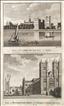
Lambeth Palace & Westminster Abbey and St. Margaret's Church. The New British Traveller was one of a number of publications by Alexander Hogg aiming to tap the bouyant market for works on British topography and antiquities. It included text on each couny, a set of county maps by T. Conder and others, and numerous copperplate prints by a variety of engravers. The work was initially issued in 60 parts from c1783, and then as a complete work from 1784. Lambeth Palace sits on the south bank of the Thames, and is the London residence of the Archbishop of London. The complex has been rebuilt and extended over the centuries, with the earliest surviving part being Lollards Tower, dating from 1435-40. The first Westminster Abbey was founded by Edward the Confessor, but the present building was begun in 1245, with work continuing until 1517. The two western towers were addded by Hawksmoor between 1722 and 1745. The Abbey has been used for all royal coronations since 1066. This print, engraved by Taylor, offers two views on one sheet. Some marginal foxing and a nick to the lower margin would be hidden by a mount.
Dulwich College, and Camberwell from the Grove. The New British Traveller was one of a number of publications by Alexander Hogg aiming to tap the bouyant market for works on British topography and antiquities. It included text on each couny, a set of county maps by T. Conder and others, and numerous copperplate prints by a variety of engravers. The work was initially issued in 60 parts from c 1783, and then as a complete work from 1784. Dulwich College is an independent, public school, founded in1619 by the Elizabethan actor, Edward Allen. It originally offered schooling for "twelve poor scholars", today risen to 1,500 rather less poor ones. At the time of this print Camberwell was still a rural village, but development had already begun along the street known as The Grove, and today the area's elegant Georgian houses have "Conservation Area" status. The print has a narrow right hand margin, but sufficient to mount.

Addington Place, Croydon, & The Royal Circus, St. George's Fields. The New British Traveller was one of a number of publications by Alexander Hogg aiming to tap the bouyant market for works on British topography and antiquities. It included text on each couny, a set of county maps by T. Conder and others, and numerous copperplate prints by a variety of engravers. The work was initially issued in 60 parts from c1783, and then as a complete work from 1784. Addington Place is a Palladian mansion built in the early 1770's by the Trecothic family. From 1807-1930 it was owned by the Church and used as a London residence by the Archbishops of Canterbury when its name changed from "Place" to "Palace". It is today again in private hands and run as a country club, conference and banqueting centre, and wedding venue. The Royal Circus opened on Blackfriars Road in 1782 and put on equine and canine dramas. It burnt down in 1799 and again in 1805, after which it was rebuilt as the Surrey Theatre. It was finally demolished in 1934. The Obelisk shown in the print was erected in 1771 in honour of Brass Crosby, Mayor of London. It still stands today, but the open space of St. George's Fields succumbed to development from 1780. The print has a little light marginal foxing which would be hidden by a mount.

The seat of Admiral Keppel, Bagshot & the seat of David Garrick, Hampton. The New British Traveller was one of a number of publications by Alexander Hogg aiming to tap the bouyant market for works on British topography and antiquities. It included text on each couny, a set of county maps by T. Conder and others, and numerous copperplate prints by a variety of engravers. The work was initially issued in 60 parts from c 1783, and then as a complete work from 1784. The Crown estate of Bagshot Park, was once a royal hunting park, and a house, known as Bagshot Park Lodge, was built there in1631-33 for the use of King Charles I. It was remodelled in 1766-72, apparently for occupation by George Keppel, Earl of Albermarle, but upon his death in 1772, it would appear to have been offered to his brother Augustus, Vice Admiral Keppel. This house was demolished in 1878, but the Park remains the home of royalty today. David Garrick was a prominent Georgian actor and theatrical manager. He moved to what was then called Hampton House in1754, first renting then purchasing and improving the property. The Adam bothers remodelled the house and Capability Brown assisted in the design of the gardens, which are notable for the Temple of Shakespeare, which still stands on the banks of the Thames, and is visible in this view. The house, today called Garrick's Villa, was converted into appartments in 1923. This print offers 2 views on one sheet. A little foxing to the margins which would be hidden by a mount.
Wandsworth & the Thames, Clapham from the Common. The New British Traveller was one of a number of publications by Alexander Hogg aiming to tap the bouyant market for works on British topography and antiquities. It included text on each couny, a set of county maps by T. Conder and others, and numerous copperplate prints by a variety of engravers. The work was initially issued in 60 parts from c 1783, and then as a complete work from 1784. This print offers two views of what were then still rural retreats for those wishing to escape the hubbub of the busy City of London - a far cry from today's London Boroughs. Some foxing the the right-hand margin and decorative border, but could be hidden by mounting within the border.


The Bishop of London's seat at Fulham, & Lord Stormont's House, Wandsworth. The New British Traveller was one of a number of publications by Alexander Hogg aiming to tap the bouyant market for works on British topography and antiquities. It included text on each couny, a set of county maps by T. Conder and others, and numerous copperplate prints by a variety of engravers. The work was initially issued in 60 parts from c1783, and then as a complete work from 1784. Fulham Palace was the residence of the Bishops of London from the early 8th century. In 1973 the Bishop's seat was relocated and the old palace became a museum, with its grounds now used as a botanic garden and allotments. The Lord Stormont here referred to was the 7th Viscount Stormont, David Murray. The family seat was at scone, but Murry needed a residence near London to pursue his political career, and chose this viilla on Wandsworth Hill, probably leased from Lady Rivers. He later became the Earl of Mansfield in 1793, inheriting Kenwood House. Two prints on one sheet. A little marginal foxing which would be hidden by a mount.


Guildford & Birmingham. The New British Traveller was one of a number of publications by Alexander Hogg aiming to tap the bouyant market for works on British topography and antiquities. It included text on each couny, a set of county maps by T. Conder and others, and numerous copperplate prints by a variety of engravers. The work was initially issued in 60 parts from c1783, and then as a complete work from 1784. Guildford's roots go back to Saxon times when it was an important centre housing a mint. A Norman castle was added around 1090, and an impressive 14th century guildhall is still extant. The town prospered, particularly from 1693 when the Wey Navigation opened, making Guildford the hub of an important waterway network. In the 20th century it also became a Bishop's seat and a University town, and is today the county town of Surrey. This print offers views of Guildford and Birmingham, but the views could be separated for separate framing. A little foxing to the top border and the margins.

Hampton Court & Chertsey. The New British Traveller was one of a number of publications by Alexander Hogg aiming to tap the bouyant market for works on British topography and antiquities. It included text on each couny, a set of county maps by T. Conder and others, and numerous copperplate prints by a variety of engravers. The work was initially issued in 60 parts from c1783, and then as a complete work from 1784. Hampton Court was constructed by Cardinal Wolsey in c1514, and passed to Henry VIII on the cardinal's fall from power in 1529. Under William and Mary the palace underwent massive extension in the Baroque style between 1688 and 1694. It is today managed by "Historic Royal Palaces" and open to the public. Chertsey is a very old town which grew up around Chertsey Abbey, founded in 666 AD.It became a Thames crossing of importance, but at the time of this print was possibly most famous for its cricket team who in 1778 heavily defeated a side representing "the rest of England". A narrow right-hand margin, but sufficient to mount, thus also hiding a few marginal spots.
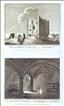
Guildford Castle & The Castle's Ancient Crypt. The Antiquities of England and Wales was the product of Alexander Hogg who was well known as a partwork publisher. Under the claimed authorship of Henry Boswell it was issued serially from c1787-9, and subsequently made available as a complete work. The format was typically 2 (though sometimes up to 6) prints to a page, with one or two accompanying pages of descriptive text on each pair of subjects. It also included the set of English county maps by Thomas Kitchin first used in the London Magazine from 1747-54. Guildford Castle is of Norman foundation, probably dating from shortly after 1086, and added to over the years.It was a royal residence until 1611 when it passed into private hands. It has been owned by Guildford Corporation since 1885. The grounds are today public gardens, the gatehouse a museum, and the keep has been restored as a visitor centre. This print, engraved by Hawkins, offers 2 views on 1 sheet, and is supplied with the original, accompanying text.
Guildford Castle . The Antiquities of England and Wales was the product of Alexander Hogg who was well known as a partwork publisher. Under the claimed authorship of Henry Boswell it was issued serially from c1787-9, and subsequently made available as a complete work. The format was typically 2 (though sometimes up to 6) prints to a page, with one or two accompanying pages of descriptive text on each pair of subjects. It also included the set of English county maps by Thomas Kitchin first used in the London Magazine from 1747-54. Guildford Castle is of Norman foundation, probably dating from shortly after 1086, and added to over the years.It was a royal residence until 1611 when it passed into private hands. It has been owned by Guildford Corporation since 1885. The grounds are today public gardens, the gatehouse a museum, and the keep has been restored as a visitor centre.
Lambeth Palace. The Antiquities of England and Wales was the product of Alexander Hogg who was well known as a partwork publisher. Under the claimed authorship of Henry Boswell it was issued serially from c1787-9, and subsequently made available as a complete work. The format was typically 2 (though sometimes up to 6) prints to a page, with one or two accompanying pages of descriptive text on each pair of subjects. It also included the set of English county maps by Thomas Kitchin first used in the London Magazine from 1747-54. Lambeth Palace sits on the south bank of the Thames, and is the London residence of the Archbishop of London. The complex has been rebuilt and extended over the centuries, with the earliest surviving part being Lollards Tower, dating from 1435-40. Ths print, engraved by Ellis, offers 2 views on 1 sheet, and is supplied with the original accompanying text. A couple of marginal spots.
Mother Ludlam's Hole, near Farnham. The Antiquities of England and Wales was the product of Alexander Hogg who was well known as a partwork publisher. Under the claimed authorship of Henry Boswell it was issued serially from c1787-9, and subsequently made available as a complete work. The format was typically 2 (though sometimes up to 6) prints to a page, with one or two accompanying pages of descriptive text on each pair of subjects. It also included the set of English county maps by Thomas Kitchin first used in the London Magazine from 1747-54. Mother Ludlam's Hole is a cave in a sandstone cliif at Moor Park, near Farnham.Mother Ludlam was supposedly a white witch who lived in the cave, and with whom several local legends are associated. A spring, rising within the cave, once provided the water supply for nearby Waverley Abbey, and monks named the spot St. Mary's Well. It the 18th century it was visited as a picturesque grotto, with a stone arched entrance added by the Victorians.
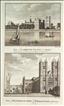
Lambeth Palace and Westminster Abbey. The Antiquities of England and Wales was the product of Alexander Hogg who was well known as a partwork publisher. Under the claimed authorship of Henry Boswell it was issued serially from c1787-9, and subsequently made available as a complete work. The format was typically 2 (though sometimes up to 6) prints to a page, with one or two accompanying pages of descriptive text on each pair of subjects. It also included the set of English county maps by Thomas Kitchin first used in the London Magazine from 1747-54. Lambeth Palace sits on the south bank of the Thames, and is the London residence of the Archbishop of London. The complex has been rebuilt and extended over the centuries, with the earliest surviving part being Lollards Tower, dating from 1435-40. The first Westminster Abbey was founded by Edward the Confessor, but the present building was begun in 1245, with work continuing until 1517. The two western towers were addded by Hawksmoor between 1722 and 1745. The Abbey has been used for all royal coronations since 1066. This print, engraved by Taylor, offers two views on one sheet, and is supplied with the original, accompanying text.

Croydon Palace, Bermondsey Abbey, Farnham Castle (all Surrey) & Bramber Castle, Bramber Church, Begeham Abbey (all Sussex). The Antiquities of England and Wales was the product of Alexander Hogg who was well known as a partwork publisher. Under the claimed authorship of Henry Boswell it was issued serially from c1787-9, and subsequently made available as a complete work. The format was typically 2 (though sometimes up to 6) prints to a page, with one or two accompanying pages of descriptive text on each pair of subjects. It also included the set of English county maps by Thomas Kitchin first used in the London Magazine from 1747-54. This anonymous print, offers 6 views on one sheet (3 of Surrey interest), and is supplied with the original, accompanying text. Croydon Palace was the summer residence of the Archbishops of Canterbury from the 1400's until it was sold in 1870, in favour of a new Palace at Nearby Addington. The old buildings survived, and had a variety of uses until their purchase for the foundation of Old Place School, founded c1889. The school continues today. Bermondsey Abbey was founded in 1082 but was mostly demolished after the dissolution, with only picturesqye ruins remaining by the time of this print. Today, Bermondsey Market occupies the site. Farnham Castle was first built 1138, but subsequently demolished and then rebult in the 12th and 13th centuries. It was owned by the Bishops of Winchester for over 500 years. The old Bishop's Palace is today a conference and weddings venue, but the Keep is maintained by English Heritage with free public access.
Box Hill and the Dorking Railway. The British Gazetteer was authored by B. Clarke and published by H.G. Collins in 1852. Apart from topographical text listings, it included a set of county maps (originally by Rowe), and a small series of railway prints after drawings by J.F. Burrell. This print was engraved by A. Ashley and shows the well-known beauty spot of Box Hill, with the railway viaduct in the distance.