W. Kip Camden's Britannia 1637 (1607)
The first five editions of Camden's successful history and topography of Britain were without maps, but for the sixth edition of 1607 the engravers William Hole and William Kip were commissioned to provide a set of maps of the counties of England and Wales, plus 3 general maps of the countries comprising the new "United Kingdom". These maps were retained for the subsequent 1610 and 1637 editions. They are based on the earlier work of Saxton, Norden, Smith and Owen. This attractively coloured example is from the 1637 edition.
Repair to lower centrefold, not affecting the printed area, and a short repaired tear to bottom right margin impinging c1.5cm into the printed area.
J. Speed England Fully Described 1716-54 (1612)
John Speed's maps of the English and Welsh counties are amongst the most decorative of early, British cartographic work, and are eagerly sought after today. They were first published in 1612 in The Theatre of the Empire of Great Britaine, designed as a companion volume to Speed's History of Great Britaine. The maps were based on the earlier surveys of Saxton, Norden and a few others, with engraving contracted to Jodocus Hondius whose signature appears on 33 of the maps. Speed's greatest innovation was the inclusion of inset plans of major towns and cities. Although some were copied from earlier work, for many towns this was first plan ever published. Speed's county atlas was re-issued a number of times for a period of around 160 years, with new publishers making various small changes and updates to the maps over time. This example bears the imprint of Henry Overton, who probably acquired the Speed plates in c 1713. Imprints began to be changed from c 1716, all being revised by c 1720. The maps were issued as a complete Speed atlas under the title indicated, but also used with other stock in the collation of "made-up" county atlases. the Speed plates were acquired by Dicey by 1754 when again issued with his imprint. Repair to centrefold.
This small county atlas of England and Wales was first issued in 1748 by a consortium of 7 publishers who also had a stake in the publication of Daniel Defoe's Tour Through the Whole Island of Great Britain. It was advertised as a companion volume to Defoe's work, or as a pocket atlas in its own right. Thomas Hutchinson's name appears as the engraver on 2 maps, but the rest are unsigned and may be by a variety of hands. They are sometimes also known as Osborne/Wale maps. There was a second edition in 1756.
T. Kitchin The Antiquities of England and Wales 1789 (1749)
This map was first published in the November 1749 edition of the London Magazine, which between 1747 and 1754 issued a complete set of English county maps by Thomas Kitchin. The maps were later re-published by Alexander Hogg in Boswell's Antiquities of England & Wales, initially in partwork from c 1787-9, and then in several complete editions of the work up to 1798. This example of the Kent map is from the first complete edition of Boswell's Antiquities dating from c1789.
The New British Traveller was originally issued as a weekly partwork by the publisher Alexander Hogg, commencing in 1783. Once the series of 60 parts was completed in 1784 title pages were provided for the pages to be bound in a single volume. The work is a topographical review of Great Britain, containing numerous prints and a set of county and general maps. The maps are of varying sizes, being typically arranged 2,3 or 4 to a single page, with adjoining borders. When separated this means individual maps will be trimmed to the border on one or two sides and are often re-margined for mounting and framing. The map of Kent is re-margined on two sides and sold ready-mounted. The text pages for the county may be available on request at no extra charge.
John Aikin (or Aiken) wrote this topographical work for children in order "to make my young countrymen better acquainted than they are usually found to be with their native land". The first edition of 1788 did not include county maps, but these were added for the second edition of 1790, from which this example comes. The work was published by Joseph Johnson, but the maps are unsigned. There were four later editions of the book with the maps, and one without. The Kent map is fairly simple, befitting the needs of its target audience. Modern hand colouring. Supplied mounted and with the original, accompanying text pages from the work.
B. Capper Topographical Dictionary of the UK 1808
Benjamin Pitts Capper was the author of this topographical directory, first published by R. Phillips in 1808. The maps were engraved, and possibly drawn by H. Cooper. Later editions of the work carry the imprint of G.and W.B. Whittaker who re-published the book from 1825-34. This example is from the first edition of 1808, with the hundreds shown in original, full wash colour.
This detailed and well engraved map was one of a set first published around 1812-14 by Robert Rowe, who was probably also their draftsman and engraver. The maps were initially sold singly in folding format until their collective issue in 1816 as The English Atlas. The plates were later acquired by Henry Teesdale, who amended titles and imprints and re-issued the work as the New British Atlas in 1829, with several re-issues up to 1842. The plates were later acquired and used by H.G. Collins and then by G. Philip and Son, who both used them as the base for lithographic transfers for a variety of works up to c1860. This example is from the 1830 second edition of Teesdale's atlas. Original wash colour. A few short, repaired, marginal tears, not affecting the printed image.
A. Fullarton Bell's New and Comprehensive Gazetteer of England and Wales 1834
These maps were first published in partwork by Fullarton and Co. in 1833-34 in James Bell's New and Comprehensive Gazetteer of England and Wales. The complete work was subsequently re-issued three times in 1834, 1836 and 1837. They were later re-published (again by Fullarton) in 1840 in The Parliamentary Gazetteer of England and Wales, with several further re-issues up to 1849. The maps were engraved on steel and sometimes bear the name of the engraver and sometimes not. This example is from the 1834 edition of Bell's Gazetteer and bears the signature of R. Scott as engraver. Supplied mounted and ready for framing.
This work was published in 1835 as a companion volume to Lewis's Topographic Dictionary. It contains county and borough maps, drawn by R. Creighton and engaved by J.& C. Walker, and was designed to show the electoral and boundary changes effected by the 1832 Reform Act. There were 2 issues of the work in 1835 and 1840, this example of the county map being from the 1835 first edition. Original outline colour.
A map of the Isle of Thanet. Thomas Moule's antiquarian leanings are evident in his series of highly decorative county maps - a stylistic throwback in an age when cartographic work had become much plainer and more utilitarian. The maps were engraved by W. Smollinger, J. Bingley and J. Dower, and first appeared in Moule's English Counties Delineated, a partwork with text issued from 1830-32. They were subsequently made available as a complete work in 1837 under the same title, and were later re-issued in Barclay's Universal English Dictionary between 1842 and 1852. This latter work ran to several editions and the maps were often updated between editions to show the latest growth of the railway network. The Thanet map is one of several which, unlike the county maps, did not appear in all editions.This example in modern colour is from Barclay's Dictionary.
Thomas Moule's antiquarian leanings are evident in this series of highly decorative county maps - a stylistic throwback in an age when cartographic work had become much plainer and more utilitarian. The maps were engraved by W. Smollinger, J. Bingley and J. Dower, and first appeared in Moule's English Counties Delineated, a partwork with text issued from 1830-32. They were subsequently made available as a complete work in 1837 under the same title, and were later re-issued in Barclay's Universal English Dictionary between 1842 and 1852. This latter work ran to several editions and the maps were often updated between editions to show the latest growth of the railway network. This example in modern colour is from the 1852 edition of Barclay's Dictionary. It is supplied mounted and ready for framing.
J. Duncan A Complete County Atlas of England and Wales 1840-45 (1825)
Coloured. These maps were first published in 1825, and probably sold singly. In 1833 they were re-published by James Duncan in a thematic atlas to illustrate the representative changes brought about by the 1832 Reform Act. There were later re-issues in 1840 and 1845 with the addition of railways, and this map dates from one of these editions.
The Walker's British Atlas was first issued in 1837, and ran to many subsequent editions with frequent updates to railways and other information. This example is from the editions of 1854 or 1856 - so dated from the railways shown, the publisher's imprints, and the population figures quoted. Full wash colour.
These maps first appeared in Rowe's English Atlas of 1816, being subsequently acquired by a succession of later publishers and used in a variety of their works. They were modified and updated during this time. This example is the second lithographic transfer for Clarke's British Gazetteer, published in 1852 by H.G. Collins. Folded and trimmed just within bottom right hand border to fit the volume. A short repaired tear impinging 1cm within right hand border.
R. Morden Camden's Britannia 1695-1772 (1695)
Camden's Britannia - a history and topography of Britain - was first published in 1586 and had a long and successful publication history. County maps by Kip and Hole were addded in 1607, and these also appeared in the editions of 1610 and 1637. Over 50 year's later it was decided to issue a new and updated edition. The original Latin text was re-translated by Edmund Gibson, and Robert Morden was commissioned to provide a new set of county and general maps in a more modern style. The revised work was issued in 1695. There were 4 further editions of the Gibson/Morden work, the last in 1772, before a further updated version by Richard Gough was launched in 1789, with new maps by John Cary. This attractively coloured example is from one of the Gibson editions and comes in a modern light brown frame.
T. Kitchin Index sheet to a large scale county map. 1769
This is the index sheet to a large scale county map surveyed by Andrews, Dury and Herbert and published in 1769. The map was drawn at 2 inches to the mile, and was printed on 25 sheets. Kitchin is named as the engraver on this index sheet, which is itself dissected into 15 sections and mounted on linen, presumably for folding into a slip case. The linen has a label to verso on which the French wording "Carte Generale" appears, although the map itself is entirely in English. The map shows good detail for an index map, and the lathes are marked with original outline colour.
Jacques Nicholas Bellin spent over 50 years working for the French Hydrographic Service. He was commissioned to produce new surveys of coastal waters throughout the world, and produced a large number of attractive charts of high quality. These appeared in various editions of his several published works, and were also often sold individually. This chart entitled "Carte du Compte de Kent et du Pas de Calais" is dated 1759, and shows full inland details of Kent, and the western parts of Sussex and Surrey, together with detail of the Picardy coast from Dunkerque to Etaples.
C. Smith New English Atlas 1828/1833 (1822)
In 1822 Charles Smith issued a county atlas with maps based on his larger county maps which had been in circulation for over 20 years. The new maps were smaller in scale, but the atlas bore the same title as that in which his larger maps appeared. They are clearly drawn and engraved, but although there were several editions of the atlas, they are today amongst the rarer of the 18th century county maps. This example is from the edition of 1828 or 1833, in which the maps have no date in the imprint, but before railways were added for the edition of 1844. Original outline colour.
James Wallis's New British Atlas was first published in 1813 by S.A. Oddy. There was a second edition in 1816. This example is from the first edition and is dated 1812 on the imprint. It is in attractive, original, full wash colour, and in good condition.
W.H. Smith W.H. Smith & Son's Reduced Ordnance Map of Kent and Envirrons c1875-90
This is one of series of maps produced by W.H. Smith and Son by lithographic transfer from Bartholomew's "Imperial map of England and Wales According to the Ordnance Survey". The maps were sold at 1 shilling each from Smiths chain of railway station boookshops. They were based on the original surveys of the Ordnance Survey, but was issued at a reduced scale of 4 inches to the mile.The map is linen-backed (but not dissected), and folds into card covers which bear the quoted title. The map itself bears a slightly different title, namely "Environs of Dover and Watering Places of Kent". Original wash colour.
T. Murray An Atlas of the English Counties 1830
The title page of Murray's county atlas states that the maps were "Projected on the basis of the Trigonometrical Survey by order of the hon.ble The Board of Ordnance, under the superindendance of T.L. Murray". This might seem to imply the project had at least the official blessing, if not the active involvement of the Ordnance Survey, but is more likely to be a marketing puff. D. Hodson has suggested that the maps were copied from those of William Ebden published from 1825-8, both sets also being engraved by the same firm of Hoare & Reeves. Murray's Atlas was first published in 1830, with second and third editions in 1831 and 1832, the latter with the adddition of electoral data. by 1838 the plates had been acquired by W. Robson & Co. who published and sold the maps individually, and also used them in their commercial directories. This example is from the first edition of 1830. Original colour.
J. Lodge Untitled Atlas of the English Counties c1795
This was one of a set of county maps engraved by John Lodge and issued between 1787 and 1790 in The Political Magazine, and Parliamentary, Naval, Military and Literary Journal, published initially by John Murray, and later by R. Butters. The maps were subsequently collected together and re-issued as an atlas (without title page) around 1795. For this atlas edition the imprint with the publication date and engraver's and publisher's signatures was removed from the maps. This example is from the atlas edition. The maps are well engraved in the plainer style then coming into vogue. They are uncommon, and sought by collectors. Modern colour.
These maps (without the decorative borders) were first issued in 1821 in Miller's New Miniature Atlas. The plates were later acquired by William Darton who re-issued them as a miniature atlas, but also used the maps, now further embellished by country scenes, in this children's work. Reuben Ramble is an invented character. Original colour to the illustrations.
Antonio Zatta was a Venetian publisher and his world atlas, the Atlante Novissimo (New Atlas) was his greatest claim to fame. It was issued in 4 volumes between the years 1779 and 1785, each volume bearing a different date. The work contained maps of just 4 English counties - Surry, Kent, Essex and Middlesex - which all appeared in Volume I, issued in 1779. They were drawn by G. Petteri and engraved by G. Zuliani, and are generally found, as here, with sparse original colour. Uncommon.
R. Blome England Exactly Described 1715 (1681)
Blome's smaller series of county maps have a puzzling history. They seem to have been initiated before his larger maps for Britannia, but were not published until 1681 when they appeared under the title Speed's Maps Epitomiz'd. Blome re-issued them twice before his death in 1705. The plates were subsequently acquired by Thomas Taylor who brought out a new edition in 1715 titled England Exactly Described. There were further editions in 1715 (by Taylor), and in c1731 (by Thomas Bakewell). These later editions had roads added to the maps. This example of the map of the county of Kent is from the 1715 edition of the work. Original hand colour.
Anon. Gentleman's Magazine 1764
London Environs/North-West Kent. This single sheet is one of four that together make up a larger map of the London Environs, titled An Accurate Map of the Country Sixteen Miles Round London, Drawn and Engrav'd from an Actual Survey. The sheets were included in 4 separate numbers (January, April, May & June, 1764) of Vol 34 of the Gentleman's Magazine. They were intended to be conjoined into a single map to be bound into the completed volume at the year end. This is the lower/right sheet of the four, and mainly covers part of north-west Kent. No engraver is named. A rare survivor.
E. Bowen The General Magazine of Arts and Sciences/The Natural History of England 1756
This map first appeared in the October 1756 number of Benjamin Martin's General Magazine of Arts and Sciences, a monthly partwork which between 1755 and 1762 included a series of county maps. The magazine's format was novel, each issue covering 5 (later 6) subject areas. The intention was that all those parts relating to any one subject could later be rebound into subject volumes, for which individual title pages would be issued. In 1763 title pages for a two volume set were issued for those parts relating to natural history. Subscribers could then, if so desired, rebind their original partworks, and new purchasers could purchase the completed work under the title, The Natural History of England. There were no later re-issues and the maps are today not common.
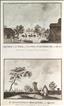
Gravesend and Woolwich from the Thames. The New British Traveller was one of a number of publications by Alexander Hogg aiming to tap the bouyant market for works on British topography and antiquities. It included text on each couny, a set of county maps by T. Conder and others, and numerous copperplate prints by a variety of engravers. The work was initially issued in 60 parts from c 1783, and then as a complete work from 1784. This print offers 2 views of north Kent towns from the river. The bottom-left corner of the white margin is missing, but the print would still frame up successfully.
Foots Cray Place and Hayes Place. The New British Traveller was one of a number of publications by Alexander Hogg aiming to tap the bouyant market for works on British topography and antiquities. It included text on each couny, a set of county maps by T. Conder and others, and numerous copperplate prints by a variety of engravers. The work was initially issued in 60 parts from c 1783, and then as a complete work from 1784. Foots Cray Place, near Sidcup, was built in 1754 for Bourchier Cleve. The property was ravaged by fire in 1949, and demolished the following year. Hayes Place was the home of the elder and younger Pitt, who both became Prime Minister. The property was bought by Pitt the elder in 1754 and remodelled. Later owners demolished the house in 1933 for redevelopment. The print was a waterstain to the top-right border, and some marginal foxing. Both faults would be hidden by judicious mounting.
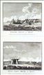
Chelsea from Battersea & the Thames at Northfleet. The New British Traveller was one of a number of publications by Alexander Hogg aiming to tap the bouyant market for works on British topography and antiquities. It included text on each couny, a set of county maps by T. Conder and others, and numerous copperplate prints by a variety of engravers. The work was initially issued in 60 parts from c 1783, and then as a complete work from 1784. This print offers two views, both featuring the River Thames. Narrow right-hand margin.
Canterbury. The New British Traveller was one of a number of publications by Alexander Hogg aiming to tap the bouyant market for works on British topography and antiquities. It included text on each couny, a set of county maps by T. Conder and others, and numerous copperplate prints by a variety of engravers. The work was initially issued in 60 parts from c 1783, and then as a complete work from 1784. Some foxing and worm holes to the margins of the print, which could be hidden by judicious mounting.
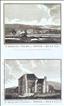
Strangers' Hall, Christ Church Priory, Canterbury. The Antiquities of England and Wales was the product of Alexander Hogg who was well known as a partwork publisher. Under the claimed authorship of Henry Boswell it was issued serially from c1787-9, and subsequently made available as a complete work. The format was typically two (though sometimes up to 6) prints to a page, with one or two accompanying pages of descriptive text on each pair of subjects. It also included the set of English county maps by Thomas Kitchin first used in the London Magazine from 1747-54. Christ Church Priory was a Benedictine foundation added to Canterbury Cathedral in the late 10th century. This print was engraved by Coote.
Barfreston Church. The Antiquities of England and Wales was the product of Alexander Hogg who was well known as a partwork publisher. Under the claimed authorship of Henry Boswell it was issued serially from c1787-9, and subsequently made available as a complete work. The format was typically two (though sometimes up to 6) prints to a page, with one or two accompanying pages of descriptive text on each pair of subjects. It also included the set of English county maps by Thomas Kitchin first used in the London Magazine from 1747-54. Barfreston is a small village between Canterbury and Dover, which has as its parish church, one of the best preserved Norman churches in England. It dates from the 12th century, and is too small to have its own belltower, this difficiency being remedied by hanging the bell ina nearby yew tree and ringing it from within the church by a series of levers. This print was engraved by Peltre.
The Grand Door of Barfreston Church. The Antiquities of England and Wales was the product of Alexander Hogg who was well known as a partwork publisher. Under the claimed authorship of Henry Boswell it was issued serially from c1787-9, and subsequently made available as a complete work. The format was typically two (though sometimes up to 6) prints to a page, with one or two accompanying pages of descriptive text on each pair of subjects. It also included the set of English county maps by Thomas Kitchin first used in the London Magazine from 1747-54. Barfreston is a small village between Canterbury and Dover, which has as its parish church, one of the best preserved Norman churches in England. It dates from the 12th century, and is too small to have its own belltower, this difficiency being remedied by hanging the bell ina nearby yew tree and ringing it from within the church by a series of levers. This print was engraved by Peltre.
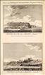
Dover Castle. The Antiquities of England and Wales was the product of Alexander Hogg who was well known as a partwork publisher. Under the claimed authorship of Henry Boswell it was issued serially from c1787-9, and subsequently made available as a complete work. The format was typically two (though sometimes up to 6) prints to a page, with one or two accompanying pages of descriptive text on each pair of subjects. It also included the set of English county maps by Thomas Kitchin first used in the London Magazine from 1747-54. Dover Castle stands on a site used by the pre-Roman Belgic tribe and by the Romans themselves, who buily a lighthouse there, the remains of which can still be seen. A wood castle was built there by William the Conqueror, which was rebuilt in stone and extended in the 12th century. Having successfully survived the civil war intact, the castle was further extended and refortified in the late 1700's in fear of a Naploeonic invasion which never came. In World War ii it was an important command centre. Today the site is owned by English Heritage with public access. This print offers two views engraved by Lowry, and is supplied with the original, accompanying text from the work.
Canterbury Castle. The Antiquities of England and Wales was the product of Alexander Hogg who was well known as a partwork publisher. Under the claimed authorship of Henry Boswell it was issued serially from c1787-9, and subsequently made available as a complete work. The format was typically 2 (though sometimes up to 6) prints to a page, with one or two accompanying pages of descriptive text on each pair of subjects. It also included the set of English county maps by Thomas Kitchin first used in the London Magazine from 1747-54. A moote and bailey castle was built in Canterbury by William the Conqueror soon after the Norman invasion. This was replaced by a new castle in stone on a nearby site, built between 1100 and 1135. The remains - mostly the keep - are today owned by the local authority and open to the public. This print, engraved by Goldar, is supplied with the original accompanying text page and plan of the castle from the work. A couple of spots.
Canterbury - St. Augustine's Monastery & the City Walls. The Antiquities of England and Wales was the product of Alexander Hogg who was well known as a partwork publisher. Under the claimed authorship of Henry Boswell it was issued serially from c1787-9, and subsequently made available as a complete work. The format was typically 2 (though sometimes up to 6) prints to a page, with one or two accompanying pages of descriptive text on each pair of subjects. It also included the set of English county maps by Thomas Kitchin first used in the London Magazine from 1747-54. St. Augustine's Abbey was a Benedictine foundation dating back to 598 AD. After the dissolution of the monasteries it fell into decay. Part of the surviving ruins were incorporated into King's College School, with the other remains maintained by English Heritage who open them to the public. Canterbury's city walls rest on Roman foundations, and were rebuilt with new stone between c1378 and 1405, with 24 towers and 6 gates. Today only Westgate and about half the original length of the walls survives, much of which can be walked. This print, engraved by Goldar, offers 2 views, and is supplied with the original, accompanying text and a plan of the monastery.
St. Martin's Priory, Dover. The Antiquities of England and Wales was the product of Alexander Hogg who was well known as a partwork publisher. Under the claimed authorship of Henry Boswell it was issued serially from c1787-9, and subsequently made available as a complete work. The format was typically 2 (though sometimes up to 6) prints to a page, with one or two accompanying pages of descriptive text on each pair of subjects. It also included the set of English county maps by Thomas Kitchin first used in the London Magazine from 1747-54. St. Martin's Priory was a religious house of 22 canons founded in the early 7th century on a different site (today the Parish church). A new priory was built for the order between 1131 and 1140 on the site of the modern Dover Priory Railway Station. The monastery decayed after the dissolution by Henry VIII. Part of the ruins were demolished by the building of the station in the 1860's and part were incorporated into Dover College, which opened in 1871. This print, engraved by Lowry, offers 2 views on one sheet, and is supplied with the original, accompanying text. A few spots to the margins.
Bradsole Abbey. The Antiquities of England and Wales was the product of Alexander Hogg who was well known as a partwork publisher. Under the claimed authorship of Henry Boswell it was issued serially from c1787-9, and subsequently made available as a complete work. The format was typically 2 (though sometimes up to 6) prints to a page, with one or two accompanying pages of descriptive text on each pair of subjects. It also included the set of English county maps by Thomas Kitchin first used in the London Magazine from 1747-54. St. Radigund's Abbey at Bradsole was founded in 1191 as a Premonstratensian religious house, a few miles from Dover. Today the gateway is still mostly intact, and a few other surviving ruins have been incorporated into the farmhouse which occupies the site. This print was engraved by Goldar. A few light, marginal spots.
Halling House and Ket's Coity House, near Rochester.. The Antiquities of England and Wales was the product of Alexander Hogg who was well known as a partwork publisher. Under the claimed authorship of Henry Boswell it was issued serially from c1787-9, and subsequently made available as a complete work. The format was typically 2 (though sometimes up to 6) prints to a page, with one or two accompanying pages of descriptive text on each pair of subjects. It also included the set of English county maps by Thomas Kitchin first used in the London Magazine from 1747-54. Halling House was first built in 1077 as a Palace for the Bishop of Rochester, being subject torebuilds in 1184 and the 1320's. It later fell into disrepair. Many of the ruins were demilished in the 18th century, with the Hall being converted to a dwelling house. The few surviving ruins were restored in 1983. Ket's (or Kit's) Coity House is a neolithic, chambered, long barrow, used for burials. It still stands today on Blue Bell Hill near Aylesford, with free public access to the site, now maintained by English Heritage. This print, engraved by Lowry, offers 2 views, and is supplied with the original, accompanying text. A couple of spots to the lower margin.

St. Mary's and All Saints' College, Maidstone. The Antiquities of England and Wales was the product of Alexander Hogg who was well known as a partwork publisher. Under the claimed authorship of Henry Boswell it was issued serially from c1787-9, and subsequently made available as a complete work. The format was typically 2 (though sometimes up to 6) prints to a page, with one or two accompanying pages of descriptive text on each pair of subjects. It also included the set of English county maps by Thomas Kitchin first used in the London Magazine from 1747-54. St. Mary's and All Saints is today the parish church of Maidstone. It was built bewteen 1396-8, and is one of the finest perpendicular churches in the country. It was founded together with an ecclesiatical college which closed in 1546. Part of the college buildings were demolished in the 19th century, but some important buildings remain and are today owned by Maidstone Borough Council. This print, engraved by Taylor, is supplied with the original, accompanying text from the work.
Saltwood Castle. The Antiquities of England and Wales was the product of Alexander Hogg who was well known as a partwork publisher. Under the claimed authorship of Henry Boswell it was issued serially from c1787-9, and subsequently made available as a complete work. The format was typically 2 (though sometimes up to 6) prints to a page, with one or two accompanying pages of descriptive text on each pair of subjects. It also included the set of English county maps by Thomas Kitchin first used in the London Magazine from 1747-54. Saltwood Castle, just outside Hythe, is recorded as dating from 488 when it was first built by Aesc, King of Kent. It was passed to the ownership of the church in 1026. It was rebuilt in stone by the Normans in the 12th and succeeding centuries. It still stands today as the private, family home of the Clark family. This print, engraved by Taylor, is supplied with the original, accompanying text from the work.
Foots-Cray Place, Sidcup. The Antiquities of England and Wales was the product of Alexander Hogg who was well known as a partwork publisher. Under the claimed authorship of Henry Boswell it was issued serially from c1787-9, and subsequently made available as a complete work. The format was typically 2 (though sometimes up to 6) prints to a page, with one or two accompanying pages of descriptive text on each pair of subjects. It also included the set of English county maps by Thomas Kitchin first used in the London Magazine from 1747-54. Foots Cray Place, near Sidcup, was a Palladian mansion built in 1754 for Bourchier Cleve. The property was ravaged by fire in 1949, and demolished the following year.
Upnor Castle, Chatham. The Antiquities of England and Wales was the product of Alexander Hogg who was well known as a partwork publisher. Under the claimed authorship of Henry Boswell it was issued serially from c1787-9, and subsequently made available as a complete work. The format was typically 2 (though sometimes up to 6) prints to a page, with one or two accompanying pages of descriptive text on each pair of subjects. It also included the set of English county maps by Thomas Kitchin first used in the London Magazine from 1747-54. Upnor Castle was built in 1559-64 as an artillery fort on the River Medway, intended to protect the dockyards at Chatham and the fleet moored on the river. It was further stengthened and modified in 1599-1601. The fort remained in military occupation until 1945. It is now owned by English Heritage, and is open to the public. This anonymous print is supplied with the original, accompanying text from the work.
Lyme Castle, Leighbourn Castle, Leeds, Castle, the Old Church at Dover Castle, Faversham Abbey, & the Mote Bulwark at Dover.. The Antiquities of England and Wales was the product of Alexander Hogg who was well known as a partwork publisher. Under the claimed authorship of Henry Boswell it was issued serially from c1787-9, and subsequently made available as a complete work. The format was typically 2 (though sometimes up to 6) prints to a page, with one or two accompanying pages of descriptive text on each pair of subjects. It also included the set of English county maps by Thomas Kitchin first used in the London Magazine from 1747-54. This anonymous print offers 6 views on 1 sheet, all of Kentish interest, and is supplied with the original accompanying text pages from the work.
Chilham, Allingham and Cowling Castles, Davynton and Dartford Priories, and the Chiding Stone, near Tonbridge. The Antiquities of England and Wales was the product of Alexander Hogg who was well known as a partwork publisher. Under the claimed authorship of Henry Boswell it was issued serially from c1787-9, and subsequently made available as a complete work. The format was typically 2 (though sometimes up to 6) prints to a page, with one or two accompanying pages of descriptive text on each pair of subjects. It also included the set of English county maps by Thomas Kitchin first used in the London Magazine from 1747-54. This anonymous print offers 6 views on 1 sheet, all of Kentish interest, and is supplied with the original accompanying text pages from the work.
Author not known. Picturesque Europe c1875/6
At Coney Hill, Hayes Common, Kent. Picturesque Europe was a serialised partwork, designed as a showcase for steel and wood engravings after and by significant artists of the day. The 60 parts were published monthly from 1875 to 1880.When sets of parts were completed, they were also sold as complete volumes, building to a full 5-volume set, 2 volumes of which were devoted to the British Isles.This wood-cut print shows a view on Hayes Common, a 79 hectare open space now in the London Borough of Bromley. Hayes Common was the first common to be given protection from enclosure and development under the Metropolitan Commons Act of 1866. This print bears a signature which is unfortunately hard to decipher - possibly Yetell? It appeared in part 6 of the work in 1875/6.
Author not known. Picturesque Europe c1875/6
Tomb of the Black Prince, Canterbury Cathedral. Picturesque Europe was a serialised partwork, designed as a showcase for steel and wood engravings after and by significant artists of the day. The 60 parts were published monthly from 1875 to 1880.When sets of parts were completed, they were also sold as complete volumes, building to a full 5-volume set, 2 volumes of which were devoted to the British Isles.This wood-cut print shows the Tomb of the Black Prince in Canterbury Cathedral. Prince Edward was the eldest son of King Edward III, and much famed for his military prowess at the battle of Crecy and Poitirs against the French.He died in 1376 - one year before his father - probably from a long term illness most likely to be amoebic dysentry. This print was engraved by J.W. Whymper after a drawing by P. Skelton. A slight stain.