Camden's Britannia - a history and topography of Britain - was first published in 1586 and had a long and successful publication history. County maps by Kip and Hole were addded in 1607, and these also appeared in the editions of 1610 and 1637. Over 50 year's later it was decided to issue a new and updated edition. The original Latin text was re-translated by Edmund Gibson, and Robert Morden was commissioned to provide a new set of county and general maps in a more modern style. The revised work was issued in 1695. There were 4 further editions of the Gibson/Morden work, the last in 1772, before a further updated version by Richard Gough was launched in 1789, with new maps by John Cary. This example is from the first Gibson edition of 1695. Repair to centrefold.
With descriptive text below and to verso. In 1695 John Seller published a county atlas titled Anglia Contracta. The plates were much later acquired by Francis Grose, revised, and used in a supplement to his partwork on British antiquities. The supplement with maps was first published in 1787, and ran to several later editions.
Britannia Depicta was one of 3 pocket-sized reductions of Ogilby's road book that appeared within an 18 month timeframe between 1719 and 1720. It was more innovative than the others in including much additional topographical and historical information (researched by John Owen) on the maps. The work was a commercial success and ran to many later editions, this example being from the first edition of 1720.
E. Bowen Royal English Atlas 1777 (c1764)
The Royal English Atlas, first published around 1764, was probably an attempt to repeat the commercial success of The Large English Atlas, with a somewhat smaller format. The maps were again engraved by Kitchin and Bowen, and the partners in the enterprise were based around the consortium that had finally brought out The Large English Atlas in 1760. This time, however, they misjudged the market, and although there were some later re-issues of the atlas, the modern rarity of the maps suggests it was not very successful. This example, dated 1777, bears the publishers' imprint of R. Sayer,J. Bennett, J. Bowles and C. Bowles. Slight browning to the outer margins, and centrefold repairs without loss. Original outline colour.
J. Ellis Ellis's English Atlas 1766 (1765)
Joseph Ellis's English Atlas was an entry into the market for small county atlases by its publishers Robert Sayer and Carington Bowles. The county maps were closely based upon those drawn by Thomas Kitchin for the 1763 topographical work England Illustrated, the major difference being the attractive vignettes which replaced Kitchin's rococco cartouches. The atlas was first published in 1765, and soon became a commercial success, running to many later editions. It was promoted as a travelling atlas, and made available in various formats. These included a version with the maps printed back to back on each page, as with this example from a 1766 edition which has a map of Nottinghamshire on the reverse.
Harrison's atlas was published in 1791, but maps were engraved and dated between 1787 and 1791, and may have been sold singly as completed. Northumberland is dated 1789, and carries the names of Haywood and Sudlow as draftsman and engraver respectively.
J. Cary Camden's Britannia 1806 (1789)
Camden's Britannia was first published in 1586. County maps by Kip and Hole were first added in 1607, being supplanted by those of Robert Morden for the 5 editions from 1695 to 1772. In 1789 a new translation of the work by Richard Gough was published by T. Payne and G. & J. Robinson with updated and modernised maps by John Cary. The same maps were also later used in Cary's New British Atlas of 1805. They can be found uncoloured, with outline colour and with full wash colour. This example is from the second Gough edition of Britannia, published in 1806, and the maps are in full wash colour - the most desirable state. Close trimmed to right hand border but outside the printed area.
Charles Smith was a successful London publisher and map-seller, whose work is stylistically very similar to that of John Cary. His large format New English Atlas first came to market in 1804, but many of the maps have also been found in folding format and may have been sold individually before the publication of the atlas. Smith's maps were well designed and accurate, making use of the large scale county surveys of the previous half-century. The atlas was a commercial success and was up-dated and re-published regularly until c1865 (the latter editions produced by lithographic transfer). This example is from the 1808 second edition, and is in bright and original full colour.
B. Capper Topographical Dictionary of the UK 1808
Benjamin Pitts Capper was the author of this topographical directory, first published by R. Phillips in 1808. The maps were engraved, and possibly drawn by H. Cooper. Later editions of the work carry the imprint of G.and W.B. Whittaker who re-published the book from 1825-34. This example is from the first edition of 1808, with the hundreds shown in original, full wash colour.
J. Cary New English Atlas 1811 (1809)
It is suprising that Cary's large county atlas was issued as late as 1809, as individual maps from it seem to have been sold singly from 1801. The atlas format was perhaps to compete with the similarly sized atlas of Charles Smith, which went under the same title and was published in 1804. It is perhaps Cary's finest production, the maps being notable for their fine design, detail and engraving. The atlas ran to several later editions by Cary, and the plates were later used for a variety of lithographic transfers by G.F. Cruchley. This example is from the second edition of 1811, and is in original full colour.
Original full colour. Repaired tear impinging c7cm within bottom centre of the printed area. The Greenwoods surveyed all the counties from 1817-33 for their beautifully engraved county atlas finally published in 1834. Maps were also sold singly as produced. The Northumberland map is corrected to 1831, and this example was sold in atlas format.
Thomas Moule's antiquarian leanings are evident in this series of highly decorative county maps - a stylistic throwback in an age when cartographic work had become much plainer and more utilitarian. The maps were engraved by W. Smollinger, J. Bingley and J. Dower, and first appeared in Moule's English Counties Delineated, a partwork with text issued from 1830-32. They were subsequently made available as a complete work in 1837 under the same title, and were later re-issued in Barclay's Universal English Dictionary between 1842 and 1852. This latter work ran to several editions and the maps were often updated between editions to show the latest growth of the railway network. This example in modern colour is from the 1842 edition of Barclay's Dictionary in which the maps are usually found close trimmed. Two repaired tears at bottom of map impinging c2 cm into the printed area - priced accordingly.
J. Duncan A Complete County Atlas of England and Wales 1840-45 (1825)
Coloured. These maps were first published in 1825, and probably sold singly. In 1833 they were re-published by James Duncan in a thematic atlas to illustrate the representative changes brought about by the 1832 Reform Act. There were later re-issues in 1840 and 1845 with the addition of railways, and this map dates from one of these editions. A little light offsetting.
J. Lodge Untitled Atlas of the English Counties c1795
This was one of a set of county maps engraved by John Lodge and issued between 1787 and 1790 in The Political Magazine, and Parliamentary, Naval, Military and Literary Journal, published initially by John Murray, and later by R. Butters. The maps were subsequently collected together and re-issued as an atlas (without title page) around 1795. For this atlas edition the imprint with the publication date and engraver's and publisher's signatures was removed from the maps. This example is from the atlas edition. The maps are well engraved in the plainer style then coming into vogue. They are uncommon, and sought by collectors.
J. Cary Traveller's Companion 1790-1828 (1790)
Original outline colour. Cary's Traveller's Companion was first published in 1790. It proved very popular as a pocket road book, and ran to several editions up to c 1828.
Jan Jansson was one of Amsterdam's leading 17th century mapmakers, and a close rival to the Blaeu family. His multi-volume world atlas first saw the introduction of 6 maps of individual English counties into the German edition of 1636, and a further 11 of English and Welsh counties in the Dutch edition of 1644. But when Jansson saw the 1645 Blaeu volume with more decorative maps covering all the English and Welsh counties, he felt obliged to revise his existing plates and complete the set in order to compete. His new volume covering England and Wales was first published in the 1646 Latin text edition of the Atlas Novus. There were several later editions by Jansson, and later issues by Schenk and Valk who acquired the plates in 1694. Latin text to verso dates this copy as from the 1646 or 1659 editions. Original colour. Minor centrefold repairs, not impinging the printed area.
J. Luffman A New Pocket Atlas and Geography of England and Wales 1806 (1803)
John Luffman's atlas was designed as a geographical aid to children. It was first issued in 1803, with a second edition in 1806 which is distinguished, as with this example, by the positioning of the plate number immediately above the circular map. It is uncommon. Short repaired tear to top margin not affecting the printed area.
This detailed and well engraved map was one of a set first published around 1812-14 by Robert Rowe, who was probably also their draftsman and engraver. The maps were initially sold singly in folding format until their collective issue in 1816 as The English Atlas. The plates were later acquired by Henry Teesdale, who amended titles and imprints and re-issued the work as the New British Atlas in 1829, with several re-issues up to 1842. The plates were later acquired and used by H.G. Collins and then by G. Philip and Son, who both used them as the base for lithographic transfers for a variety of works up to c1860. This example is from the 1830 second edition of Teesdale's atlas. Original wash colour.
J. Speed England Fully Described in a Complete Set of Mapps of ye Countys of England and Wales, with their Islands c1713-43 (1612)
John Speed's maps of the English and Welsh counties are amongst the most decorative of early, British cartographic work, and are eagerly sought after today. They were first published in 1612 in The Theatre of the Empire of Great Britaine, designed as a companion volume to Speed's History of Great Britaine. The maps were based on the earlier surveys of Saxton, Norden and a few others, with engraving contracted to Jodocus Hondius whose signature appears on 33 of the maps. Speed's greatest innovation was the inclusion of inset plans of major towns and cities. Although some were copied from earlier work, for many towns this was first plan ever published. Speed's county atlas was re-issued a number of times for a period of around 160 years, with new publishers making various small changes and updates to the maps over time. This example bears the imprint of Henry Overton - one of the rarer imprints found on Speed maps - and could have been issued either in a complete Speed atlas, or in one of Overton's "composite" atlases, using individual maps from various sources. Overton probably also sold Speed's maps singly.
T. Murray An Atlas of the English Counties 1830
The title page of Murray's county atlas states that the maps were "Projected on the basis of the Trigonometrical Survey by order of the hon.ble The Board of Ordnance, under the superindendance of T.L. Murray". This might seem to imply the project had at least the official blessing, if not the active involvement of the Ordnance Survey, but is more likely to be a marketing puff. D. Hodson has suggested that the maps were copied from those of William Ebden published from 1825-8, both sets also being engraved by the same firm of Hoare & Reeves. Murray's Atlas was first published in 1830, with second and third editions in 1831 and 1832, the latter with the adddition of electoral data. by 1838 the plates had been acquired by W. Robson & Co. who published and sold the maps individually, and also used them in their commercial directories. This example is from the first edition of 1830. Original colour.
T. Kitchin The Antiquities of England and Wales 1789 (1748)
This map was first published in the October 1748 edition of the London Magazine, which between 1747 and 1754 issued a complete set of English county maps by Thomas Kitchin. The maps were later re-published by Alexander Hogg in Boswell's Antiquities of England & Wales, initially in partwork from c 1787-9, and then in several complete editions of the work up to 1798. This example of the Northumberland map is from the first complete edition of Boswell's Antiquities dating from c1789.
A. Perrot L' Angleterre, ou Description Historique et Topographique du Royaume de la Grande-Bretagne 1824-35
The text for this French topographical work on Britain was written by George Depping, the maps being drawn by Aristide Perrot and engraved by A. Migneret. It was first published in 1824, with subsequent editions in 1828 and 1835. The maps often cover more than one county as in this example which also includes Durham. The surrounding decorative border shows the typical produce and wares of the counties. Original outline colour. A few small, light-brown spots.
This work was published in 1835 as a companion volume to Lewis's Topographic Dictionary. It contains county and borough maps, drawn by R. Creighton and engaved by J.& C. Walker, and was designed to show the electoral and boundary changes effected by the 1832 Reform Act. There were 2 issues of the work in 1835 and 1840, this example of the county map being from the 1835 first edition. Original outline colour.
The New British Traveller was originally issued as a weekly partwork by the publisher Alexander Hogg, commencing in 1783. Once the series of 60 parts was completed in 1784 title pages were provided for the pages to be bound in a single volume. The work is a topographical review of Great Britain, containing numerous prints and a set of county and general maps. The maps are of varying sizes, being typically arranged 2,3 or 4 to a single page, with adjoining borders. When separated this means individual maps will be trimmed to the border on one or two sides and are often re-margined for mounting and framing. The map of Northumberland is re-margined on one side and sold ready-mounted. The text pages for the county may be available on request at no extra charge.
This distance chart, showing the mileages between the main towns of Northumberland, was part of the county entry which first appeared in the April 1724 number of this serialised, topographical partwork . John Morphew was the publisher of the work, but the author of the distance chart is uncertain, although sometimes erroneously ascribed to Robert Morden whose smaller county maps also appeared in this work. The chart also includes the coats of arms of the 3 county boroughs. Modern colour. Supplied mounted.
This small county atlas of England and Wales was first issued in 1748 by a consortium of 7 publishers who also had a stake in the publication of Daniel Defoe's Tour Through the Whole Island of Great Britain. It was advertised as a companion volume to Defoe's work, or as a pocket atlas in its own right. Thomas Hutchinson's name appears as the engraver on 2 maps, but the rest are unsigned and may be by a variety of hands. They are sometimes also known as Osborne/Wale maps. There was a second edition in 1756.
R. Morden Magna Britannia et Hibernia 1724-1739 (701)
Morden's set of smaller maps may originally have been drawn and engraved for Camden's Britannia, but rejected as too small. They were first published in 1701 in The New Description and State of England. This example is from Magna Britannia et Hibernia, originally issued as a 92 part topographical work between 1714 and 1731, but gradually also made available in 6 finished, bound volumes. The text and map of Northumberland first appeared in the partwork in January 1724, but further editions were issued up to 1739 with the maps unchanged. Original hand colour.

Tinmouth (Tynemouth) Castle. The Antiquities of England and Wales was the product of Alexander Hogg who was well known as a partwork publisher. Under the claimed authorship of Henry Boswell it was issued serially from c1787-9, and subsequently made available as a complete work. The format was typically 2 (though sometimes up to 6) prints to a page, with one or two accompanying pages of descriptive text on each pair of subjects. It also included the set of English county maps by Thomas Kitchin first used in the London Magazine from 1747-54. Tynemouth Castle originated as a Benedictine Priory where the Kings of Northumbria were buried. The Anglo-Saxon monastery was destroyed by the Danes, but refounded in 1090. Stone defensive walls were added in1296, and a gatehouse and barbican in in 1390. After the dissolution of the monasteries the Priory Church was retained to serve the parish until it was replaced in 1668. The remaining ruins are now maintained by English Heritage and open to the public.

Monastery of the Black Friars, Newcastle. The Antiquities of England and Wales was the product of Alexander Hogg who was well known as a partwork publisher. Under the claimed authorship of Henry Boswell it was issued serially from c1787-9, and subsequently made available as a complete work. The format was typically 2 (though sometimes up to 6) prints to a page, with one or two accompanying pages of descriptive text on each pair of subjects. It also included the set of English county maps by Thomas Kitchin first used in the London Magazine from 1747-54. The order of Dominicans (The Blackfriars) founded their friary in Newcastle in 1239. It is sited to the NW of the city centre just within the city walls. Upon the dissolution of the monasteries, most of the buildings were demolished and the site passed to the city Corporation, who in 1552 leased out the remaining cloister buildings to the city's craft guilds. With the decline of the guilds the buildings fell into disrepair. They were restored by the Corporation between 1973 and 81, and are now leased out as craft workshops and a restaurant, though the Tanners Guild also still meet there. This print, engraved by Hawkins, is supplied with the original, accompanying text from the work.

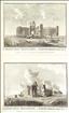
Dunstanbrough (Dunstanburgh) Castle. The Antiquities of England and Wales was the product of Alexander Hogg who was well known as a partwork publisher. Under the claimed authorship of Henry Boswell it was issued serially from c1787-9, and subsequently made available as a complete work. The format was typically 2 (though sometimes up to 6) prints to a page, with one or two accompanying pages of descriptive text on each pair of subjects. It also included the set of English county maps by Thomas Kitchin first used in the London Magazine from 1747-54. The castle was bulit by Thomas Earl of Lancaster as a stronghold against King Edward II, construction beginning in 1313. The Earl was, however captured and executed following a rebellion against the king, and his castle passed to John of Gaunt who further strengthened it against Scottish incursions. It endured two sieges during the wars of the Roses, but subsequently fell into disrepair and decay. The impressive remains are today under the guardianship of English Heritage, and are open to the public.This print was engraved by Hawkins.

Mitford Castle. The Antiquities of England and Wales was the product of Alexander Hogg who was well known as a partwork publisher. Under the claimed authorship of Henry Boswell it was issued serially from c1787-9, and subsequently made available as a complete work. The format was typically 2 (though sometimes up to 6) prints to a page, with one or two accompanying pages of descriptive text on each pair of subjects. It also included the set of English county maps by Thomas Kitchin first used in the London Magazine from 1747-54. Mitford Castle dates from the late 11th century, and had a number of owners before it was destroyed in the early 14th century, possibly by the Scots. Much of its stone was used to build a Jacoberan Mansion, but the remaining, imposing ruins still stand on a hill overlooking the small town of Mitford, near Morpeth. Its current owners are conserving and restoring the remains with grant aid from English Heritage. This print, engraved by Roberts, is supplied with the original, accompanying text from the work. A few spots.

Gate at Tynemouth Castle. The Antiquities of England and Wales was the product of Alexander Hogg who was well known as a partwork publisher. Under the claimed authorship of Henry Boswell it was issued serially from c1787-9, and subsequently made available as a complete work. The format was typically 2 (though sometimes up to 6) prints to a page, with one or two accompanying pages of descriptive text on each pair of subjects. It also included the set of English county maps by Thomas Kitchin first used in the London Magazine from 1747-54. Tynemouth Castle originated as a Benedictine Priory where the Kings of Northumbria were buried. The Anglo-Saxon monastery was destroyed by the Danes, but refounded in 1090. Stone defensive walls were added in1296, and a gatehouse and barbican in in 1390. After the dissolution of the monasteries the Priory Church was retained to serve the parish until it was replaced in 1668. The remaining ruins are now maintained by English Heritage and open to the public. This print was engraved by Grainger. A little foxing.
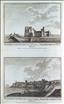
Tynemouth Castle and Priory. The Antiquities of England and Wales was the product of Alexander Hogg who was well known as a partwork publisher. Under the claimed authorship of Henry Boswell it was issued serially from c1787-9, and subsequently made available as a complete work. The format was typically 2 (though sometimes up to 6) prints to a page, with one or two accompanying pages of descriptive text on each pair of subjects. It also included the set of English county maps by Thomas Kitchin first used in the London Magazine from 1747-54. Tynemouth Castle originated as a Benedictine Priory where the Kings of Northumbria were buried. The Anglo-Saxon monastery was destroyed by the Danes, but refounded in 1090. Stone defensive walls were added in1296, and a gatehouse and barbican in in 1390. After the dissolution of the monasteries the Priory Church was retained to serve the parish until it was replaced in 1668. The remaining ruins are now maintained by English Heritage and open to the public. This print, engraved by Walker, offers 2 views on one sheet, and is supplied with the original, accompanying text from the work.

The Monks Stone, near Tinmouth (Tynemouth). The Antiquities of England and Wales was the product of Alexander Hogg who was well known as a partwork publisher. Under the claimed authorship of Henry Boswell it was issued serially from c1787-9, and subsequently made available as a complete work. The format was typically 2 (though sometimes up to 6) prints to a page, with one or two accompanying pages of descriptive text on each pair of subjects. It also included the set of English county maps by Thomas Kitchin first used in the London Magazine from 1747-54. The Monks' Stone originally stood in a field in the village of Preston, near North Shields, and was probably a boundary marker for nearby Tynemouth Priory. The stone bears a (probably later) inscription commemorating a murder, which may be a reference to a story of an incident between one of the monks and Lord Deveral. The stone has now been relocated to the grounds of the Priory where it may stilll be seen. This print was engraved by Peltro. A little spotting.
Lindisfarne Abbey. The Antiquities of England and Wales was the product of Alexander Hogg who was well known as a partwork publisher. Under the claimed authorship of Henry Boswell it was issued serially from c1787-9, and subsequently made available as a complete work. The format was typically 2 (though sometimes up to 6) prints to a page, with one or two accompanying pages of descriptive text on each pair of subjects. It also included the set of English county maps by Thomas Kitchin first used in the London Magazine from 1747-54. The island of Lindisfarne (or Holy Island) lies 1 mile off the north Northumbrian coast, and joined to the mainland at low tide.A Priory was founded there by St. Aidan in 634 AD, and which under St. Cuthbert became a leading centre for learning and the Christian faith, producing such works as the still surviving Lindisfarne Gospels. The monks fled the island in 878 after attacks by the Vikings and Danes, but the Priory was re-established in 1093, and continued until the dissolution of the monasteries, after which the buildings decayed. The ruins are today in the care of English Heritage and open to the public. This print, engraved by Wooding, offers 2 views on one sheet, and is supplied with the original, accompanying text from the work. A couple of light spots.
Hulne Abbey. The Antiquities of England and Wales was the product of Alexander Hogg who was well known as a partwork publisher. Under the claimed authorship of Henry Boswell it was issued serially from c1787-9, and subsequently made available as a complete work. The format was typically 2 (though sometimes up to 6) prints to a page, with one or two accompanying pages of descriptive text on each pair of subjects. It also included the set of English county maps by Thomas Kitchin first used in the London Magazine from 1747-54. Hulne Abbey was a Carmelite Priory founded in 1240 near Alnwick. After the dissolution of the monasteries the site passed to the Percy Family, Dukes of Northumberland. It is still owned by them and the substantial ruins in what is now Hulne Park are open to the public (pedestrians only). This print , engraved by Peltro, offers 2 views on one sheet, and is supplied with the original text from the work. A little marred by foxing.
Alnwick Abbey. The Antiquities of England and Wales was the product of Alexander Hogg who was well known as a partwork publisher. Under the claimed authorship of Henry Boswell it was issued serially from c1787-9, and subsequently made available as a complete work. The format was typically 2 (though sometimes up to 6) prints to a page, with one or two accompanying pages of descriptive text on each pair of subjects. It also included the set of English county maps by Thomas Kitchin first used in the London Magazine from 1747-54. Alnwick Abbey was founded in 1147 by the Premonstratensian order of monks. After the dissolution of the Monasteries the site eventually passed to the Dukes of Northumberland. Today only the impressive gatehouse remains above ground, standing In Hulne Park. The Park is open to pedestrians. This print, engraved by Peltro, is supplied with the original, accompanying text from the work.

Bamborough (Bamburgh) Castle. The Antiquities of England and Wales was the product of Alexander Hogg who was well known as a partwork publisher. Under the claimed authorship of Henry Boswell it was issued serially from c1787-9, and subsequently made available as a complete work. The format was typically 2 (though sometimes up to 6) prints to a page, with one or two accompanying pages of descriptive text on each pair of subjects. It also included the set of English county maps by Thomas Kitchin first used in the London Magazine from 1747-54. Bamburgh's Norman castle was built soon after the conquest. It stood by 1095 and became a property of the crown soon after, and its defences were extended and strengthened over the following years. Around 1300 it passed again into private hands, and had a succession of different owners until it was bought in the late 19th century by William Armstrong, who restored it. It is today still owned and inhabited by the Armstrong family who open it to the public. This print, engraved by Thornton, is supplied with the original, accompanying text from the work.