J. Senex Speculum Britanniae - Part 1 1723 (1593)
John Norden's Speculum Britanniae (Mirror of Britain) was conceived as a project to gradually cover the whole country with a series of books each covering the topography and history of individual counties. The first part to be issued was of Middlesex, published in 1593, with text and 3 maps engraved by Peter van den Keere. The maps were of Middlesex, and the cities of London and Westminster. Although Norden continued work on his project for the rest of his life, only a few further counties were actually published during his lifetime, probably due to a lack of support after the death of Lord Burghley who had sponsored his early efforts. The accuracy of his maps is attested by the fact that his successor John Speed preferred to follow Norden rather than Saxton where both choices were available to him. Norden's map of Middlesex is noteworthy as being the first county map to include the major roads - it would be a further 100 years before roads began to appear on most county maps. There were later editions of Part 1 of the Speculum issued in 1623 and 1655, and a new version in 1723 with newly engraved plates by John Senex closely following the original designs. This example of the Middlesex map is believed to be from the 1723 edition - a most uncommon item. Supplied mounted ready for framing.
J. Blaeu Theatrum Orbis Terrarum 1645-72 (1645)
The Blaeu family were one of the leading Dutch map producers of the 17th century. Their major work was a multi volume world atlas initiated by Willem Blaeu and expanded by his son Joan. Their maps were beautifully designed and engraved, and are often found with original colour, making them most desirable to collectors. 1645 saw the first publication of volume 4 of the atlas, containing maps of England and Wales. There were several re-issues between then and 1672 when most of Blaeu's plates were lost in a fire which engulfed his Amsterdam premises. An excellent example in original colour and supplied in an attractive frame.
Jan Jansson was one of Amsterdam's leading 17th century mapmakers, and a close rival to the Blaeu family. His multi-volume world atlas first saw the introduction of 6 maps of individual English counties into the German edition of 1636, and a further 11 of English and Welsh counties in the Dutch edition of 1644. But when Jansson saw the 1645 Blaeu volume with more decorative maps covering all the English and Welsh counties, he felt obliged to revise his existing plates and complete the set in order to compete. His new volume covering England and Wales was first published in the 1646 Latin text edition of the Atlas Novus. In 1694 the printing plates were acquired by the Amsterdam firm of Schenk and Valk who made various revisions, and sold the maps singly or in composite atlases. This example, covering both Middlesex and Hertfordshire, bears the Schenk and Valck imprint, and has had a graticule of latitude and longitude added. Original full colour.
J. Ogilby An Actuall Survey of Middlesex c1730 (1672/3)
John Ogilby is best known for his road maps, titled Britannia, but this was intended as only part of a larger project to included an English county atlas. Only 3 maps for the county atlas were ever produced - Kent, Essex and Middlesex. Unusually, in an age of plagiarism, they were based on original surveys. The Middlesex map was engraved by Walter Binneman, and was first published in 1672-3. This example is the later re-issue by George Willdey who acquired the printing plates sometime after Ogilby's death in 1676, and would have sold the map as an individual item, and in composite atlases such as his edition of Saxton's atlas in c1730.A light water stain to the top-right corner, a repair to the lower centrefold and re-margined with minor restoration to the trimmed lower border. Still an attractive copy of a rare map.
T. Kitchin The Antiquities of England and Wales c1789 (1748)
This map was first published in the March 1748 edition of the London Magazine, which between 1747 and 1754 issued a complete set of English county maps by Thomas Kitchin. The maps were later re-published by Alexander Hogg in Boswell's Antiquities of England & Wales, initially in partwork from c 1787-9, and then in several complete editions of the work up to 1798. This example of the Middlesex map is from the first complete edition of Boswell's Antiquities dating from c1789.
Antonio Zatta was a Venetian publisher and his world atlas, the Atlante Novissimo (New Atlas) was his greatest claim to fame. It was issued in 4 volumes between the years 1779 and 1785, each volume bearing a different date. The work contained maps of just 4 English counties - Surry, Kent, Essex and Middlesex - which all appeared in Volume I, issued in 1779. They were drawn by G. Petteri and engraved by G. Zuliani, and are generally found, as here, with sparse original colour. Uncommon.
J. Cary Camden's Britannia 1806 (1789)
Camden's Britannia was first published in 1586. County maps by Kip and Hole were first added in 1607, being supplanted by those of Robert Morden for the 5 editions from 1695 to 1772. In 1789 a new translation of the work by Richard Gough was published by T. Payne and G. & J. Robinson with updated and modernised maps by John Cary. The same maps were also later used in Cary's New British Atlas of 1805. They can be found uncoloured, with outline colour and with full wash colour. This example is from the second Gough edition of Britannia, published in 1806, and the maps are in full wash colour - the most desirable state.
John Aikin (or Aiken) wrote this topographical work for children in order "to make my young countrymen better acquainted than they are usually found to be with their native land". The first edition of 1788 did not include county maps, but these were added for the second edition of 1790, from which this example comes. The work was published by Joseph Johnson, but the maps are unsigned. There were four later editions of the book with the maps, and one without. The Middlesex map is fairly simple, befitting the needs of its target audience, and the text may be available at no extra charge.
B. Capper Topographical Dictionary of the UK 1808
Benjamin Pitts Capper was the author of this topographical directory, first published by R. Phillips in 1808. The maps were engraved, and possibly drawn by H. Cooper. Later editions of the work carry the imprint of G.and W.B. Whittaker who re-published the book from 1825-34. This example is from the first edition of 1808, with the hundreds shown in original, full wash colour.
J. Cary New English Atlas 1811 (1809)
It is suprising that Cary's large county atlas was issued as late as 1809, as individual maps from it seem to have been sold singly from 1801. The atlas format was perhaps to compete with the similarly sized atlas of Charles Smith, which went under the same title and was published in 1804. It is perhaps Cary's finest production, the maps being notable for their fine design, detail and engraving. The atlas ran to several later editions by Cary, and the plates were later used for a variety of lithographic transfers by G.F. Cruchley. This example is from the second edition of 1811, and is in original full colour. Repaired tear to centrefold.
A. Perrot L'Angleterre, ou Description Historique et Topographique du Royaume de la Grande-Bretagne 1824-35
The text for this French topographical work on Britain was written by George Depping, the maps being drawn by Aristide Perrot and engraved by A. Migneret. It was first published in 1824, with subsequent editions in 1828 and 1835. The maps often cover more than one county, but Middlesex gets a map to itself. The surrounding decorative border shows the typical produce and wares of the counties. Original outline colour.
Original full colour. Repair to bottom centrefold. The Greenwoods surveyed all the counties from 1817-33 for their beautifully engraved county atlas finally published in 1834. Maps were also sold singly as produced. The Middlesex map is corrected to 1829, and this example was sold in atlas format.
This work was published in 1835 as a companion volume to Lewis's Topographic Dictionary. It contains county and borough maps, drawn by R. Creighton and engaved by J.& C. Walker, and was designed to show the electoral and boundary changes effected by the 1832 Reform Act. There were 2 issues of the work in 1835 and 1840, this example of the county map being from the 1835 first edition. Original outline colour.
Thomas Moule's antiquarian leanings are evident in this series of highly decorative county maps - a stylistic throwback in an age when cartographic work had become much plainer and more utilitarian. The maps were engraved by W. Smollinger, J. Bingley and J. Dower, and first appeared in Moule's English Counties Delineated, a partwork with text issued from 1830-32. They were subsequently made available as a complete work in 1837 under the same title, and were later re-issued in Barclay's Universal English Dictionary between 1842 and 1852. This latter work ran to several editions and the maps were often updated between editions to show the latest growth of the railway network. This example in modern colour is from one of the later editions of Barclay's Dictionary (in which the vignette of Westminster bridge is re-engraved to add the new Houses of Parliament). Supplied mounted and ready for framing.
J. Duncan A Complete County Atlas of England and Wales 1840-45 (1825)
Coloured. These maps were first published in 1825, and probably sold singly. In 1833 they were re-published by James Duncan in a thematic atlas to illustrate the representative changes brought about by the 1832 Reform Act. There were later re-issues in 1840 and 1845 with the addition of railways, and this map dates from one of these editions. A little light offsetting.
A. Fullarton Bell's New and Comprehensive Gazetteer of England and Wales 1833-37
These maps were first published by Fullarton and Co. in 1833 in James Bell's New and Comprehensive Gazetteer of England and Wales which was re-issued three times in 1834, 1836 and 1837. They were subsequently re-published (again by Fullarton) in 1840 in The Parliamentary Gazetteer of England and Wales, with several further re-issues up to 1849. The maps were engraved on steel and sometimes bear the name of the engraver and sometimes not. This example is from Bell's Gazetteer and bears the signature of R. Scott as engraver. Supplied mounted and ready for framing.
T. Murray An Atlas of the English Counties 1830
Maps for Murray's atlas were copied from those of William Ebden published from 1825-8, and were engraved by the same firm of Hoare & Reeves. Repairs to several marginal nicks, one just impinging the top border.
This map was engraved by J. & C. Walker and first appeared in their British Atlas of 1835. Lithographic transfers were later taken for Hobson's Fox Hunting Atlas, and in 1884 for Letts Popular County Atlas. Repairs to centrefold tears.
C. Smith New English Atlas (reduced maps) 1828 or 1833 (1822)
In 1822 Charles Smith issued a county atlas with maps based on his larger county maps which had been in circulation for over 20 years. The new maps were smaller in scale, but the atlas bore the same title as that in which his larger maps appeared. They are clearly drawn and engraved, but although there were several editions of the atlas, they are today amongst the rarer of the 18th century county maps. This example is from the edition of 1828 or 1833, in which the maps have no date in the imprint, but before railways were added for the edition of 1844. Original outline colour.
Pinnock's Guide to Knowledge was a serialised partwork which included a series of county and other maps by Joshua Archer. The maps are most unusual in being printed by a relief process from wood blocks so the lettering and detail is shown as white out of black.
This detailed and well engraved map was one of a set first published around 1812-14 by Robert Rowe, who was probably also their draftsman and engraver. The maps were initially sold singly in folding format until their collective issue in 1816 as The English Atlas. The plates were later acquired by Henry Teesdale, who amended titles and imprints and re-issued the work as the New British Atlas in 1829, with several re-issues up to 1842. The plates were later acquired and used by H.G. Collins and then by G. Philip and Son, who both used them as the base for lithographic transfers for a variety of works up to c1860. This example is from the 1830 second edition of Teesdale's atlas. Original wash colour. A couple of short, repaired, marginal tears, not affecting the printed area.
R. Dawson Plans of the Cities and Boroughs of England and Wales…..together with Outline Maps showing the Divisions of Counties… 1832
This lithographed map formed part of a Parliamentary Report showing proposed changes to electoral arrangements and boundaries which were subsequently enacted in the 1832 Reform Act. Parliament subsequently ordered the plans be published to the public at large, which was done the same year. Dawson was a Lieutenant in the Royal Engineers charged with survey and production of maps to illustrate the changes.Original colour.
J. Lodge Untitled Atlas of the English Counties c1796
This was one of a set of county maps engraved by John Lodge and issued between 1787 and 1790 in The Political Magazine, and Parliamentary, Naval, Military and Literary Journal, published initially by John Murray, and later by R. Butters. The maps were subsequently collected together and re-issued as an atlas (without title page) around 1795. For this atlas edition the imprint with the publication date and engraver's and publisher's signatures was removed from the maps. This example is from the atlas edition. The maps are well engraved in the plainer style then coming into vogue. They are uncommon, and sought by collectors. Modern colour.
James Wallis's New British Atlas was first published in 1813 by S.A. Oddy. There was a second edition in 1816. This example is from the first edition and is dated 1812 on the imprint. It is in attractive, original, full wash colour, and in good condition. Supplied mounted and ready for framing.
S. Hall A Topographical Dictionary of Great Britain and Ireland 1831
Old folds and lack of railway information support an attribution of this map to its first issue in 1831 in A Topographical Dictionary of Great Britain and Ireland by John Gorton. The map, with various amendments, later appeared in several other works including Hall's New British Atlas (1833-36) and A Travelling County Atlas (1842-1875).
Thomas Dix initiated this atlas project some time around 1816, but after his death it was carried on to completion by the publisher William Darton. The Atlas was issued in 1822, though individual maps bear various dates between 1816 and 1821. This Middlesex map is dated 1820. The maps are in attractive and original full wash colour, and are relatively scarce. Slight overall toning.

The success of the Large English Atlas from 1760 encouraged Emanuel Bowen and Thomas Kitchin to produce reduced-scale versions to cover the markets for medium and small-size atlases. The Royal English Atlas was published in c 1764 to target the medium-size market, and the Atlas Anglicanus followed for the small-scale market. Both copied the Large English Atlas in style, with rococo cartouches, and topographical notes surrounding the maps. The maps for the Atlas Anglicanus were first issued in monthly partworks between 1767 and 1768 before the complete atlas followed in 1768. Emanuel Bowen died in 1767, and his son Thomas took over the engraving of the remaining maps. Both Bowens are jointly cited as cartographers of the Middlesex map. Kitchin acted as publisher for the enterprise. There was a second edition of the atlas in c1777, before the plates passed to Carington Bowles and were updated and re-issued as Bowles' New Medium English Atlas in 1785. The Atlas Anglicanus was not a commercial success and maps from it are not commonly found.
Over the first decades of the 19th century, Samuel Neele engraved a number of maps for the Encyclopaedia Londinensis which was published serially. A number of these maps state specifically in the imprint that they were engraved for the Encyclopaedia. Though no such statement appears on the Middlesex map the named publisher is Adlard & Co.who published the work, and the address is that of the Encyclopaedia's office. An unprepossessing little map but not commonly found - one for the collector.
Miller's miniature county atlas was undated, but issued in c 1821. There were re-issues in c 1822 and 1825 under the imprints of William Darton, who presumably bought the publishing rights from Miller. This example is from the first edition by Miller. An uncommon map.
R. Whitworth Plan of the Intended Navigable Canal from Moor Fields into the River Lee at Waltham Abby c1773
This map was commissioned by the City of London, and surveyed by Robert Whitworth. It shows the proposed course of the new canal, the old River Lea, the so-called "New River", and something of the surrounding countryside.
E. Bowen The General Magazine of Arts and Sciences/The Natural History of England 1757
This map first appeared in the January 1757 number of Benjamin Martin's General Magazine of Arts and Sciences, a monthly partwork which between 1755 and 1762 included a series of county maps. The magazine's format was novel, each issue covering 5 (later 6) subject areas. The intention was that all those parts relating to any one subject could later be rebound into subject volumes, for which individual title pages would be issued. In 1763 title pages for a two volume set were issued for those parts relating to natural history. Subscribers could then, if so desired, rebind their original partworks, and new purchasers could purchase the completed work under the title, The Natural History of England. There were no later re-issues and the maps are today not common.
Langley and Belch were in partnership from 1807 to 1820, and published their county atlas in 1818. The maps are attractive, with topograhical vignettes (in this caseWaterloo Bridge and St. Paul's in London) and usually found in original full wash colour as here. After the dissolution of their partnership the map plates seem to have passed to the bookseller Joseph Phelps. Phelps re-issued the atlas in 1820, but also made the maps available singly, dissected, linen-backed and folding into slip cases. This example is from the first edition of the atlas in 1818. A repair to a small hole just to the left of the border with Buckinghamshire, but otherwise a very attractive map.
The Comprehensive Gazetteer was edited by J. Brabner and published by W. Mackenzie. Weller's map was printed by lithographic transfer for it's first and only edition in c1894. Original printed colour.
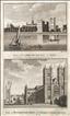
Lambeth Palace & Westminster Abbey and St. Margaret's Church. The New British Traveller was one of a number of publications by Alexander Hogg aiming to tap the bouyant market for works on British topography and antiquities. It included text on each couny, a set of county maps by T. Conder and others, and numerous copperplate prints by a variety of engravers. The work was initially issued in 60 parts from c 1783, and then as a complete work from 1784. Lambeth Palace sits on the south bank of the Thames, and is the London residence of the Archbishop of London. The complex has been rebuilt and extended over the centuries, with the earliest surviving part being Lollards Tower, dating from 1435-40. The first Westminster Abbey was founded by Edward the Confessor, but the present building was begun in 1245, with work continuing until 1517. The two western towers were addded by Hawksmoor between 1722 and 1745. The Abbey has been used for all royal coronations since 1066. This print, engraved by Taylor, offers two views on one sheet. Some marginal foxing and a nick to the lower margin would be hidden by a mount.
Mortlake and Hammersmith from the Thames. The New British Traveller was one of a number of publications by Alexander Hogg aiming to tap the bouyant market for works on British topography and antiquities. It included text on each couny, a set of county maps by T. Conder and others, and numerous copperplate prints by a variety of engravers. The work was initially issued in 60 parts from c 1783, and then as a complete work from 1784. This print is the ideal present for a fan of the University Boat Race offering views of the mid-way and finishing points of the race. Narrow right-hand margin, but enough to mount successfully. A little browning affecting the lower-right margin.

The Thames and the stairs at York Buildings, London. The New British Traveller was one of a number of publications by Alexander Hogg aiming to tap the bouyant market for works on British topography and antiquities. It included text on each couny, a set of county maps by T. Conder and others, and numerous copperplate prints by a variety of engravers. The work was initially issued in 60 parts from c 1783, and then as a complete work from 1784. This print is taken from the spot where York House, one of the great Thameside Mansions on the Strnad once stood. The watermen's stairs known as York stairs were build to an elaboarte Italianate design around 1626, and still survive, though now located in the Embankment Gardens some way away from the river. At the time they were built York House was owned by The de Vililers family, Dukes of Buckingham. The second Duke sold the house for redevelopment in 1672, and the new buildings on the site were collectively called York Buildings. A little marginal foxing to the print would be hidden by a mount.


The Bishop of London's seat at Fulham, & Lord Stormont's House, Wandsworth. The New British Traveller was one of a number of publications by Alexander Hogg aiming to tap the bouyant market for works on British topography and antiquities. It included text on each couny, a set of county maps by T. Conder and others, and numerous copperplate prints by a variety of engravers. The work was initially issued in 60 parts from c1783, and then as a complete work from 1784. Fulham Palace was the residence of the Bishops of London from the early 8th century. In 1973 the Bishop's seat was relocated and the old palace became a museum, with its grounds now used as a botanic garden and allotments. The Lord Stormont here referred to was the 7th Viscount Stormont, David Murray. The family seat was at scone, but Murry needed a residence near London to pursue his political career, and chose this viilla on Wandsworth Hill, probably leased from Lady Rivers. He later became the Earl of Mansfield in 1793, inheriting Kenwood House. Two prints on one sheet. A little marginal foxing which would be hidden by a mount.

Gunnersbury House, Wanstead House, and a detail from Bethlehem Hospital. The New British Traveller was one of a number of publications by Alexander Hogg aiming to tap the bouyant market for works on British topography and antiquities. It included text on each couny, a set of county maps by T. Conder and others, and numerous copperplate prints by a variety of engravers. The work was initially issued in 60 parts from c 1783, and then as a complete work from 1784. This print offers 3 views. Gunnersbury House was a Palladian mansion in Brentwood built sometime prior to 1742 for John Maynard. The house shown here was demolished in 1801, when the estate was sold and split into two, resulting in its replacement by 2 new houses. These still stand in Gunnersbury Park. Wanstead House was another Palladian mansion, completed 1722 for Sir Richard Child. It was demolished in 1825 when the site was sold to pay the gambling debts of the then owner William Wellesley-Pole. Bethlehem (or Bedlam) Hospital dates back to a foundation of 1347, and is Europe's oldest psychiatric hospital. At the time of this print (which shows a detail from the gateway) it occupied an impressive building in Moorfields which had opened in 1676. The hospital moved to a new site in Southwark in 1815. A little marginal worming and foxing which would be hidden by a mount.
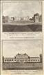
Sion House & Kenwood House. The New British Traveller was one of a number of publications by Alexander Hogg aiming to tap the bouyant market for works on British topography and antiquities. It included text on each couny, a set of county maps by T. Conder and others, and numerous copperplate prints by a variety of engravers. The work was initially issued in 60 parts from c 1783, and then as a complete work from 1784. Syon House was built in the mid 16th century for the Duke of Somerset, being subsequently acquired by the Percy Family, Dukes of Northumberland, in1594. It continues as the family's residence today, and is open to the public. Kenwood (originally Caen Wood) House in Hampstead was built in the early 17th century, and in 1754 was acquired by William Murray, Ist Earl Mansfield, who engaged Robert Adam to remodel and add to it in the 1760's and 70's. In 1925 it was purchaed by Lord Iveagh who gave it to the nation 2 years later, and it is today administered by English Hertitage who open it to the public. Two views on one print. A light stain to the lower title.

Kensington Palace, Ranelagh & Vauxhall Gardens. The New British Traveller was one of a number of publications by Alexander Hogg aiming to tap the bouyant market for works on British topography and antiquities. It included text on each couny, a set of county maps by T. Conder and others, and numerous copperplate prints by a variety of engravers. The work was initially issued in 60 parts from c 1783, and then as a complete work from 1784. Kensington Palace was built c1605 as a Jacobean mansion. It was bought by King William IV and Quenn Mary II in 1689, was remodelled and extended by Wren and became the main royal residence in London until 1860, since when it has been the home of junior and lesser members of the royal family. Vauxhall and Ranelaugh were London's two great "Pleasure Gardens", offering a garden walks, food and drink and a range of entertainments, including musical concerts in rotundas. They were popular venues for assignations between the sexes. Vauxhall opened to the public in c1660 and Ranelaugh in1742. Thier heyday was the 18th century, with both being closed by the mid 1800's. Both survive as garden - at least in part - as a public park in Vauxhall, and Ranelagh as the site of the Chelsea flower show. This print offers 3 views on one sheet. A little marginal foxing which could be hidden by a mount.
Chelsea from Battersea & The Thames, near Northfleet. The New British Traveller was one of a number of publications by Alexander Hogg aiming to tap the bouyant market for works on British topography and antiquities. It included text on each couny, a set of county maps by T. Conder and others, and numerous copperplate prints by a variety of engravers. The work was initially issued in 60 parts from c 1783, and then as a complete work from 1784. Two "London" based views of the Thames. At the time of this print Chelsea was still a village, and would not be joined to the growing metropolis for another 60 years or so. Northfleet was of importance for its dockyards, with a number of shipyards building large vessels for commercial companies such as the East India company. A narrow right-hand margin, but sufficient for mounting.

The Duke of Chando's Seat at Southgate. The New British Traveller was one of a number of publications by Alexander Hogg aiming to tap the bouyant market for works on British topography and antiquities. It included text on each couny, a set of county maps by T. Conder and others, and numerous copperplate prints by a variety of engravers. The work was initially issued in 60 parts from c 1783, and then as a complete work from 1784. The Duke of Chandos residence was Minchenden House in Southgate, now a London Borough, but then a village. The house was built some little time after 1664 for Sir Thomas Wolstenholme, with alterations in 1738 by a later owner, John Nicholl. Nicholl's daughter married James Bridges who subsequently became the 3rd Duke of Chandos, and the house was owned by him at the time this print was taken.. It later fell into disrepair, and was sold and demolished in 1853. This print has been re-margined to the lower border where separated from another view on the same sheet. A liitle marginal foxing which would be hidden by a mount.

The Churches of St Pancras and Hornsey. The New British Traveller was one of a number of publications by Alexander Hogg aiming to tap the bouyant market for works on British topography and antiquities. It included text on each couny, a set of county maps by T. Conder and others, and numerous copperplate prints by a variety of engravers. The work was initially issued in 60 parts from c 1783, and then as a complete work from 1784. This print shows the Old St. Pancras Church, which probably dates back to the 11th or 12th centuries, though most of its fabric is later. It ceased to be the parish church in 1822, when replaced by the New St. Pancras church on Euston Road. It was much restored and remodelled in the mid 19th century and continues as a place of worship today. St. Mary's Chruch in the village of Hornsey (now north London) dates from the 13th century. Althougn replaced as parish church by 2 later builds, it has survived both and continues in use today. This print offers views of both churches. A little marginal foxing which would be hidden by a mount.
Chiswick Gardens and the Serpentine River. The New British Traveller was one of a number of publications by Alexander Hogg aiming to tap the bouyant market for works on British topography and antiquities. It included text on each couny, a set of county maps by T. Conder and others, and numerous copperplate prints by a variety of engravers. The work was initially issued in 60 parts from c 1783, and then as a complete work from 1784. The first Chiswick house was a Jacobean house built in 1610. By the 1700's the property was owned by Lord Burlington who built a new Palladian Villa, and from about 1720 developed the gardens with William Kent and other architects. Both house and gardens were modelled on Roman exemplars. The Jacobean house was demolished in 1788. The Villa and gardens have been restored in recent years and survive today under a Trust. They are administered and opened to the public by English Heritage. The gardens are free of charge.
The Duke of Argyll's house at Whitton. The New British Traveller was one of a number of publications by Alexander Hogg aiming to tap the bouyant market for works on British topography and antiquities. It included text on each couny, a set of county maps by T. Conder and others, and numerous copperplate prints by a variety of engravers. The work was initially issued in 60 parts from c 1783, and then as a complete work from 1784. In 1722 Archibald Campbell, later to become the 3rd Duke of Argyll, bought 40 acres on Hounslow Heath adjoining the hamlet of Whitton. From c1732-5 he built there a Palladian Villa to a design by Roger Morris who oversaw the build. The house was known as Whitton Place and was accompanied by substantial gardens.in the late 1840's the villa was demolished and the estate was sold, much of it being developed for housing in the 20th century.

Hampton Court & Chertsey. The New British Traveller was one of a number of publications by Alexander Hogg aiming to tap the bouyant market for works on British topography and antiquities. It included text on each couny, a set of county maps by T. Conder and others, and numerous copperplate prints by a variety of engravers. The work was initially issued in 60 parts from c 1783, and then as a complete work from 1784. Hampton Court was constructed by Cardinal Wolsey in c1514, and passed to Henry VIII on the cardinal's fall from power in 1529. Under William and Mary the palace underwent massive extension in the Baroque style between 1688 and 1694. It is today managed by "Historic Royal Palaces" and open to the public. Chertsey is a very old town which grew up around Chertsey Abbey, founded in 666 AD.It became a Thames crossing of importance, but at the time of this print was possibly most famous for its cricket team who in 1778 heavily defeated a side representing "the rest of England". A narrow right-hand margin, but sufficient to mount, thus also hiding a few marginal spots.
The Royal Exchange. The Antiquities of England and Wales was the product of Alexander Hogg who was well known as a partwork publisher. Under the claimed authorship of Henry Boswell it was issued serially from c1787-9, and subsequently made available as a complete work. The format was typically 2 (though sometimes up to 6) prints to a page, with one or two accompanying pages of descriptive text on each pair of subjects. It also included the set of English county maps by Thomas Kitchin first used in the London Magazine from 1747-54. The Royal Exchange, on Cornhill, was built at the instigation of Sir Thomas Gresham and opened in 1571. Its function was as a centre for trade and commerce, its primary
occupants being London merchants. The Exchange was twice destroyed by fire and rebuillt. This print, engraved by A. Walker after a drawing by S. Donowell, illustrates the second building of 1669, and is supplied with the original, accompanying text from the work..
The Gates to the City of London. The Antiquities of England and Wales was the product of Alexander Hogg who was well known as a partwork publisher. Under the claimed authorship of Henry Boswell it was issued serially from c1787-9, and subsequently made available as a complete work. The format was typically 2 (though sometimes up to 6) prints to a page, with one or two accompanying pages of descriptive text on each pair of subjects. It also included the set of English county maps by Thomas Kitchin first used in the London Magazine from 1747-54. The walls of the city of London had 8 gates, built at different periods of time. By the mid 18th century, as defensive needs reduced and the city grew, they were seen as obstructions to traffic and some had already been demolished. In 1760 an Act was passed allowing the remaining gates to be pulled down, and all had gone by 1771. This print, engraved by Wooding, is supplied with the original, accompanying text. Some foxing.
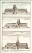
Old St. Paul's Cathedral. The Antiquities of England and Wales was the product of Alexander Hogg who was well known as a partwork publisher. Under the claimed authorship of Henry Boswell it was issued serially from c1787-9, and subsequently made available as a complete work. The format was typically 2 (though sometimes up to 6) prints to a page, with one or two accompanying pages of descriptive text on each pair of subjects. It also included the set of English county maps by Thomas Kitchin first used in the London Magazine from 1747-54. The old cathedral of St. Paul was built between 1087 and 1314, on a site which had housed 3 previous churches. It was destroyed in the great fire of London in 1666, and subsequently rebuilt in Baroque style to a design of Sir Christopher Wren, the new building being completed in 1708. The cathedral is the seat of the Bishop of London. This print offers 3 views on 1 sheet, and is supplied with the original, accompanying text from the work. A couple of light spots.
The Bridges of London. The Antiquities of England and Wales was the product of Alexander Hogg who was well known as a partwork publisher. Under the claimed authorship of Henry Boswell it was issued serially from c1787-9, and subsequently made available as a complete work. The format was typically 2 (though sometimes up to 6) prints to a page, with one or two accompanying pages of descriptive text on each pair of subjects. It also included the set of English county maps by Thomas Kitchin first used in the London Magazine from 1747-54. For many years London had only one bridge - London Bridge - linking the city with the borough of Southwark on the Surrey bank of the Thames. As the city and Southwark both grew, new bridges were built to accommodate the growing traffic, and by the time of this anonymous print there were the four bridges shown. The print is supplied with the original, accompanying text pages from the work.

Cheapside and Baynards Castle. The Antiquities of England and Wales was the product of Alexander Hogg who was well known as a partwork publisher. Under the claimed authorship of Henry Boswell it was issued serially from c1787-9, and subsequently made available as a complete work. The format was typically 2 (though sometimes up to 6) prints to a page, with one or two accompanying pages of descriptive text on each pair of subjects. It also included the set of English county maps by Thomas Kitchin first used in the London Magazine from 1747-54. At the time of this print Cheapside was the site of a major produce market and an important thoroughfare linking the City of London with Westminster. Cheapside actually means "market place". The first post-conquest Norman Baynards Castle was built by Ralph Baynard on a riverfront site to the east of the modern Blackfriars Bridge. It was demolished in 1213, and in 1276 the site became part of Blackfriars Priory. In the late medieval period a new mansion gradually evolved on a close-by site, now owned by the Dukes of York, which also became known as Baynard Castle. In turn this became the royal palace of Henry Vii and Henry VIII before passing to the Dukes of Pembroke and later the Dukes of Shrewsbury. The house was destroyed in the great fire of London in 1666, though some substantial ruins survived to be incorporated into later wharfs and timberyards. The site is now occupied by a BT office block. This print offers 2 views engrved by Wooding, and is supplied with the original, accompanying text from the work.
Lambeth Palace and Westminster Abbey. The Antiquities of England and Wales was the product of Alexander Hogg who was well known as a partwork publisher. Under the claimed authorship of Henry Boswell it was issued serially from c1787-9, and subsequently made available as a complete work. The format was typically 2 (though sometimes up to 6) prints to a page, with one or two accompanying pages of descriptive text on each pair of subjects. It also included the set of English county maps by Thomas Kitchin first used in the London Magazine from 1747-54. Lambeth Palace sits on the south bank of the Thames, and is the London residence of the Archbishop of London. The complex has been rebuilt and extended over the centuries, with the earliest surviving part being Lollards Tower, dating from 1435-40. The first Westminster Abbey was founded by Edward the Confessor, but the present building was begun in 1245, with work continuing until 1517. The two western towers were addded by Hawksmoor between 1722 and 1745. The Abbey has been used for all royal coronations since 1066. This print, engraved by Taylor, offers two views on one sheet, and is supplied with the original, accompanying text.
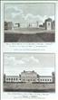
Sion House and Kenwood House. The Antiquities of England and Wales was the product of Alexander Hogg who was well known as a partwork publisher. Under the claimed authorship of Henry Boswell it was issued serially from c1787-9, and subsequently made available as a complete work. The format was typically 2 (though sometimes up to 6) prints to a page, with one or two accompanying pages of descriptive text on each pair of subjects. It also included the set of English county maps by Thomas Kitchin first used in the London Magazine from 1747-54. yon House was built in the mid 16th century for the Duke of Somerset, being subsequently acquired by the Percy Family, Dukes of Northumberland, in1594. It continues as the family's residence today, and is open to the public. Kenwood (originally Caen Wood) House in Hampstead was built in the early 17th century, and in 1754 was acquired by William Murray, Ist Earl Mansfield, who engaged Robert Adam to remodel and add to it in the 1760's and 70's. In 1925 it was purchaed by Lord Iveagh who gave it to the nation 2 years later, and it is today administered by English Hertitage who open it to the public. Two views on one page, engraved by Roberts, and supplied with the original,accompanying text from the work.

An Ancient View of St. James.s Palace, Westminster Abbey and Hall from Charing Cross. The Antiquities of England and Wales was the product of Alexander Hogg who was well known as a partwork publisher. Under the claimed authorship of Henry Boswell it was issued serially from c1787-9, and subsequently made available as a complete work. The format was typically 2 (though sometimes up to 6) prints to a page, with one or two accompanying pages of descriptive text on each pair of subjects. It also included the set of English county maps by Thomas Kitchin first used in the London Magazine from 1747-54. The title of this print describes an "Ancient View", so the idyllic view of Westminster across the fields, probably looked a little different by the 1780's. The oldest building on view is Westminster Hall built 1097-99, as part of the royal Palace of Westminster, and today part of the Houses of Parliament. Next oldest is Westminster Abbey where construction began in 1245, with work continuing until 1517. St. James's Palce was built by Henry VIII from 1531-6, and was the residence of the sovereign until George III moved to York House (today's Buckingham Palace) in 1862. It remians home to other members of the royal family. The print is supplied with the original, accompanying text from the work.
St. John's Gate, Clerkenwell. The Antiquities of England and Wales was the product of Alexander Hogg who was well known as a partwork publisher. Under the claimed authorship of Henry Boswell it was issued serially from c1787-9, and subsequently made available as a complete work. The format was typically 2 (though sometimes up to 6) prints to a page, with one or two accompanying pages of descriptive text on each pair of subjects. It also included the set of English county maps by Thomas Kitchin first used in the London Magazine from 1747-54. St. John's gate was built in 1504 as the southern gateway to the Priory of the Knights of St. John, as is the only sizeable remnant to have survived the dissolution of the monasteries. It still stands today as the museum of the revived Order of St. John, best known for the ambulance service they sponsor. This print, engraved by Peltro, offers two views of the gate on one page, and is supplied with the original, accompanying text from the work.

The Charter House (Charterhouse School). The Antiquities of England and Wales was the product of Alexander Hogg who was well known as a partwork publisher. Under the claimed authorship of Henry Boswell it was issued serially from c1787-9, and subsequently made available as a complete work. The format was typically 2 (though sometimes up to 6) prints to a page, with one or two accompanying pages of descriptive text on each pair of subjects. It also included the set of English county maps by Thomas Kitchin first used in the London Magazine from 1747-54. In 1371 a Carthusian Priory was founded just to north of Chaterhouse Square, Smithfield. Most of the monastery was demolished after the dissolution, but in 1515 the site was bought by Sir Edward North who built a large mansion there. In 1611 this property was acquired by Thomas Sutton whose will left funding for its use as a Chapel, Almshouses and School. Charterhouse School is today famous, but relocated to new premises near Godalming in 1872. The rest of the Smithfield buildings are still used as almshouses for 40 pensioners. This anonymous print of the Charterhouse is supplied with the original, accompanying text from the work.