W. Hole Camden's Britannia 1637 (1607)
The first five editions of Camden's successful history and topography of Britain were without maps, but for the sixth edition of 1607 the engravers William Hole and William Kip were commissioned to provide a set of maps of the counties of England and Wales, plus 3 general maps of the countries comprising the new "United Kingdom". These maps were retained for the subsequent 1610 and 1637 editions. They are based on the earlier work of Saxton, Norden, Smith and Owen. This attractively coloured example is from the 1637 edition.
Minor repair to fraying at bottom right edge of sheet, well outside the printed area.
J. Speed Theatre of the Empire of Great Britaine 1676 (1612)
John Speed's maps of the English and Welsh counties are amongst the most decorative of early, British cartographic work, and are eagerly sought after today. They were first published in 1612 in The Theatre of the Empire of Great Britaine, designed as a companion volume to Speed's History of Great Britaine. The maps were based on the earlier surveys of Saxton, Norden and a few others, with engraving contracted to Jodocus Hondius whose signature appears on 33 of the maps. Speed's greatest innovation was the inclusion of inset plans of major towns and cities. Although some were copied from earlier work, for many towns this was first plan ever published. Speed's county atlas was re-issued a number of times for a period of around 160 years, with new publishers making various small changes and updates to the maps over time. This example bears the imprint of Basset & Chiswell dating it to the edition of 1676.
This small county atlas of England and Wales was first issued in 1748 by a consortium of 7 publishers who also had a stake in the publication of Daniel Defoe's Tour Through the Whole Island of Great Britain. It was advertised as a companion volume to Defoe's work, or as a pocket atlas in its own right. Thomas Hutchinson's name appears as the engraver on 2 maps, but the rest are unsigned and may be by a variety of hands. They are sometimes also known as Osborne/Wale maps. There was a second edition in 1756. Faint ex-library blindstamp to top 2 corners.
J. Ellis Ellis's English Atlas 1766 (1765)
Joseph Ellis's English Atlas was an entry into the market for small county atlases by its publishers Robert Sayer and Carington Bowles. The county maps were closely based upon those drawn by Thomas Kitchin for the 1763 topographical work England Illustrated, the major difference being the attractive vignettes which replaced Kitchin's rococco cartouches. The atlas was first published in 1765, and soon became a commercial success, running to many later editions. It was promoted as a travelling atlas, and made available in various formats. These included a version with the maps printed back to back on each page, as with this example from a 1766 edition which has a map of Rutland on the reverse.
J. Cary Camden's Britannia 1806 (1789)
Camden's Britannia was first published in 1586. County maps by Kip and Hole were first added in 1607, being supplanted by those of Robert Morden for the 5 editions from 1695 to 1772. In 1789 a new translation of the work by Richard Gough was published by T. Payne and G. & J. Robinson with updated and modernised maps by John Cary. The same maps were also later used in Cary's New British Atlas of 1805. They can be found uncoloured, with outline colour and with full wash colour. This example is from the second Gough edition of Britannia, published in 1806, and the maps are in full wash colour - the most desirable state.
John Aikin (or Aiken) wrote this topographical work for children in order "to make my young countrymen better acquainted than they are usually found to be with their native land". The first edition of 1788 did not include county maps, but these were added for the second edition of 1790, from which this example comes. The work was published by Joseph Johnson, but the maps are unsigned. There were four later editions of the book with the maps, and one without. The Oxfordshire map is fairly simple, befitting the needs of its target audience, and the text may be available at no extra charge.
Charles Smith was a successful London publisher and map-seller, whose work is stylistically very similar to that of John Cary. His large format New English Atlas first came to market in 1804, but many of the maps have also been found in folding format and may have been sold individually before the publication of the atlas. Smith's maps were well designed and accurate, making use of the large scale county surveys of the previous half-century. The atlas was a commercial success and was up-dated and re-published regularly until c1865 (the latter editions produced by lithographic transfer). This example is from the 1808 second edition, and is in bright and original full colour.
B. Capper Topographical Dictionary of the UK 1808
Benjamin Pitts Capper was the author of this topographical directory, first published by R. Phillips in 1808. The maps were engraved, and possibly drawn by H. Cooper. Later editions of the work carry the imprint of G.and W.B. Whittaker who re-published the book from 1825-34. This example is from the first edition of 1808, with the hundreds shown in original, full wash colour.
J. Cary New English Atlas 1811 (1809)
It is suprising that Cary's large county atlas was issued as late as 1809, as individual maps from it seem to have been sold singly from 1801. The atlas format was perhaps to compete with the similarly sized atlas of Charles Smith, which went under the same title and was published in 1804. It is perhaps Cary's finest production, the maps being notable for their fine design, detail and engraving. The atlas ran to several later editions by Cary, and the plates were later used for a variety of lithographic transfers by G.F. Cruchley. This example is from the second edition of 1811, and is in original full colour.
James Pigot & Co's county maps were issued in their British Atlas (from c1829), in several of their national and local business directories (from 1826 for the "home counties", at least), and singly in folding form as travelling maps. They were amongst the first maps to be printed from steel instead of copper plates, allowing more accurate fine detail and less wear to the plates over time. Atlas and directories went through several editions up to around 1857, later editions from 1846 being re-named Slater's New British Atlas, with imprints changed accordingly. Original outline colour.
Original full colour. A nice example in very good condition. The Greenwoods surveyed all the counties from 1817-33 for their beautifully engraved county atlas finally published in 1834. Maps were also sold singly as produced. The Oxfordshire map is corrected to 1834, and this example's centrefold shows it was sold in atlas format.
Thomas Moule's antiquarian leanings are evident in this series of highly decorative county maps - a stylistic throwback in an age when cartographic work had become much plainer and more utilitarian. The maps were engraved by W. Smollinger, J. Bingley and J. Dower, and first appeared in Moule's English Counties Delineated, a partwork with text issued from 1830-32. They were subsequently made available as a complete work in 1837 under the same title, and were later re-issued in Barclay's Universal English Dictionary between 1842 and 1852. This latter work ran to several editions and the maps were often updated between editions to show the latest growth of the railway network. This example in modern colour is from the 1842 edition of Barclay's Dictionary in which the maps are usually found close trimmed. A little marginal foxing, and a short repaired tear at the bottom margin. Supplied mounted and ready for framing.
Between 1832 and 1834 Joshua Archer engraved a set of maps for the serialised partwork Pinnock's Guide to Knowledge. The maps were unusual in being relief printed from wooden blocks to give a "white on black" presentation. In 1847 amended versions of the maps were re-issued in Thomas Johnson's county atlas. Various changes were made to the wood blocks (including a new "piano key" border, and the addition of railways), and printing was by lithographic transfer to give a more conventional and easier to read "black on white" presentation. The amended maps from Johnson's atlas are today something of a rarity. This example is in original wash colour and in nice condition.
J. Duncan A Complete County Atlas of England and Wales 1840-45 (1825)
Coloured. These maps were first published in 1825, and probably sold singly. In 1833 they were re-published by James Duncan in a thematic atlas to illustrate the representative changes brought about by the 1832 Reform Act. There were later re-issues in 1840 and 1845 with the addition of railways, and this map dates from one of these editions. A little light offsetting.
The Walker's British Atlas was first issued in 1837, and ran to many subsequent editions with frequent updates to railways and other information. This example is from the editions of 1854 or 1856 - so dated from the railways shown, the publisher's imprints, and the population figures quoted. Full wash colour.
These maps first appeared in Rowe's English Atlas of 1816, being subsequently acquired by a succession of later publishers and used in a variety of their works. They were modified and updated during this time. This example is the second lithographic transfer for Clarke's British Gazetteer, published in 1852 by H.G. Collins. Folded and trimmed close to bottom right hand border to fit the volume.
J. Lodge Untitled Atlas of the English Counties c1795
This was one of a set of county maps engraved by John Lodge and issued between 1787 and 1790 in The Political Magazine, and Parliamentary, Naval, Military and Literary Journal, published initially by John Murray, and later by R. Butters. The maps were subsequently collected together and re-issued as an atlas (without title page) around 1795. For this atlas edition the imprint with the publication date and engraver's and publisher's signatures was removed from the maps. This example is from the atlas edition. The maps are well engraved in the plainer style then coming into vogue. They are uncommon, and sought by collectors.
J. Blaeu Theatrum Orbis Terrarum, sive Atlas Novus/Atlas Maior 1645-62
The Blaeu family were one of the leading Dutch map producers of the 17th century. Their major work was a multi volume world atlas initiated by Willem Blaeu and expanded by his son Joan. Their maps were beautifully designed and engraved, and are often found with original colour, making them most desirable to collectors. 1645 saw the first publication of volume 4 of the atlas, containing maps of England and Wales. There were several re-issues between then and 1672 when most of Blaeu's plates were lost in a fire which engulfed his Amsterdam premises. Latin text on the verso narrows dating of this example to the editions of 1645, 1648 or 1662. The map is in full colour and in excellent condition. It is supplied in an attractive and double-glazed frame allowing the text on the verso to be read.
This work was published in 1835 as a companion volume to Lewis's Topographic Dictionary. It contains county and borough maps, drawn by R. Creighton and engaved by J.& C. Walker, and was designed to show the electoral and boundary changes effected by the 1832 Reform Act. There were 2 issues of the work in 1835 and 1840, this example of the county map being from the 1835 first edition. Original outline colour.
The New British Traveller was originally issued as a weekly partwork by the publisher Alexander Hogg, commencing in 1783. Once the series of 60 parts was completed in 1784 title pages were provided for the pages to be bound in a single volume. The work is a topographical review of Great Britain, containing numerous prints and a set of county and general maps. The maps are of varying sizes, being typically arranged 2,3 or 4 to a single page, with adjoining borders. When separated this means individual maps will be trimmed to the border on one or two sides and are often re-margined for mounting and framing. The map of Oxfordshire is close trimmed to the neat lines and has been re-margined and mounted ready for framing.
James Wallis's New British Atlas was first published in 1813 by S.A. Oddy. There was a second edition in 1816. This example is from the 1813 edition, but the Oxfordshire map is unusual in lacking the publishers imprint and date present on nearly all the other maps in the source atlas. It is in attractive, original, full wash colour.
Maps for this miniature atlas were probably drawn and engraved by James Wallis, though alternative imprints serve to confuse the issue, some crediting Wallis as the printer and W. Reid as the publisher, and other listing Wallis and C. Hinton as co-publishers. It is most likely that Hinton had an early interest in the project, but dropped out before publication in 1820 to be replaced by Reid. Ownership of the plates later passed to Hodgson and Co. who issued a further edition with slightly amended title in 1825. This example has the imprint of Hinton and Wallis.
This detailed and well engraved map was one of a set first published around 1812-14 by Robert Rowe, who was probably also their draftsman and engraver. The maps were initially sold singly in folding format until their collective issue in 1816 as The English Atlas. The plates were later acquired by Henry Teesdale, who amended titles and imprints and re-issued the work as the New British Atlas in 1829, with several re-issues up to 1842. The plates were later acquired and used by H.G. Collins and then by G. Philip and Son, who both used them as the base for lithographic transfers for a variety of works up to c1860.
C. Smith New English Atlas 1828 or 1833 (1822)
In 1822 Charles Smith issued a county atlas with maps based on his larger county maps which had been in circulation for over 20 years. The new maps were smaller in scale, but the atlas bore the same title as that in which his larger maps appeared. They are clearly drawn and engraved, but although there were several editions of the atlas, they are today amongst the rarer of the 18th century county maps. This example is from the edition of 1828 or 1833, in which the maps have no date in the imprint, but before railways were added for the edition of 1844. Original outline colour.
T. Murray An Atlas of the English Counties 1830
The title page of Murray's county atlas states that the maps were "Projected on the basis of the Trigonometrical Survey by order of the hon.ble The Board of Ordnance, under the superindendance of T.L. Murray". This might seem to imply the project had at least the official blessing, if not the active involvement of the Ordnance Survey, but is more likely to be a marketing puff. D. Hodson has suggested that the maps were copied from those of William Ebden published from 1825-8, both sets also being engraved by the same firm of Hoare & Reeves. Murray's Atlas was first published in 1830, with second and third editions in 1831 and 1832, the latter with the adddition of electoral data. by 1838 the plates had been acquired by W. Robson & Co. who published and sold the maps individually, and also used them in their commercial directories. This example is from the first edition of 1830. Original colour.
E. Bowen The General Magazine of Arts and Sciences/The Natural History of England 1758
This map first appeared in the August 1758 number of Benjamin Martin's General Magazine of Arts and Sciences, a monthly partwork which between 1755 and 1762 included a series of county maps. The magazine's format was novel, each issue covering 5 (later 6) subject areas. The intention was that all those parts relating to any one subject could later be rebound into subject volumes, for which individual title pages would be issued. In 1763 title pages for a two volume set were issued for those parts relating to natural history. Subscribers could then, if so desired, rebind their original partworks, and new purchasers could purchase the completed work under the title, The Natural History of England. There were no later re-issues and the maps are today not common.
A. Fullarton Bell's New and Comprehensive Gazetteer of England and Wales 834
These maps were first published in partwork by Fullarton and Co. in 1833-34 in James Bell's New and Comprehensive Gazetteer of England and Wales. The complete work was subsequently re-issued three times in 1834, 1836 and 1837. They were later re-published (again by Fullarton) in 1840 in The Parliamentary Gazetteer of England and Wales, with several further re-issues up to 1849. The maps were engraved on steel and sometimes bear the name of the engraver and sometimes not. This example is from the 1834 edition of Bell's Gazetteer and bears the signature of R. Scott as engraver. The attractive vignette shows the view of the city from across Christ's Meadows. Modern colour. Supplied mounted and ready for framing.

Blenheim Palace, Woodstock. The New British Traveller was one of a number of publications by Alexander Hogg aiming to tap the bouyant market for works on British topography and antiquities. It included text on each couny, a set of county maps by T. Conder and others, and numerous copperplate prints by a variety of engravers. The work was initially issued in 60 parts from c 1783, and then as a complete work from 1784. The construction of Blenheim Palace began in 1705, on land gifted to John Churchil, Duke of Marlborough, by a grateful nation in recognition of his victory at the Battle of Blenheim during the War of the Spanish Succession. Parliament voted funding for the build to which the Duke also contributed. The architect was Sir John Vanburgh and the house was mostly completed by 1725, in the English Baroque style. Quarrels between the Royal House household and the Marlboroughs, and between the Dutchess and the Architect contributed to the delay, causing disruptions to the flow of funding. The house remains the seats of the Dukes of Marlborough today, and is open to the public. This print has been remargined to the top border, where separated from an adjoining view.
Friar Bacon's Study, Oxford.. The Antiquities of England and Wales was the product of Alexander Hogg who was well known as a partwork publisher. Under the claimed authorship of Henry Boswell it was issued serially from c1787-9, and subsequently made available as a complete work. The format was typically 2 (though sometimes up to 6) prints to a page, with one or two accompanying pages of descriptive text on each pair of subjects. It also included the set of English county maps by Thomas Kitchin first used in the London Magazine from 1747-54. Friar Bacon's Study (or Tower) was a 3 story building straddling the north end of South or Folly Bridge, carrying the main Oxford-Abingdon road across the Thames. It was lived and worked in by the 13th century alchemist Roger Bacon, but demolished in 1779 to allow for road widening. This print, engraved by Hawkins, is supplied with the original, accompanying text from the work.

Banbury Church. The Antiquities of England and Wales was the product of Alexander Hogg who was well known as a partwork publisher. Under the claimed authorship of Henry Boswell it was issued serially from c1787-9, and subsequently made available as a complete work. The format was typically 2 (though sometimes up to 6) prints to a page, with one or two accompanying pages of descriptive text on each pair of subjects. It also included the set of English county maps by Thomas Kitchin first used in the London Magazine from 1747-54. The Church illustrated is the old parish church, dedicated to St. Mary the Virgin. It dated from from 12th century, but its mid 15th century tower was too heavy and contributed to structural problems, exacerbated by civil war damage.. By the mid 18th century these problems were so great that it was decided to replace the building. In 1797 it was pulled down and replaced by the present parish church. This print, engraved by Hawkins, is supplied with the original, accompanying text from the work.

Godstow Nunnery. The Antiquities of England and Wales was the product of Alexander Hogg who was well known as a partwork publisher. Under the claimed authorship of Henry Boswell it was issued serially from c1787-9, and subsequently made available as a complete work. The format was typically 2 (though sometimes up to 6) prints to a page, with one or two accompanying pages of descriptive text on each pair of subjects. It also included the set of English county maps by Thomas Kitchin first used in the London Magazine from 1747-54. Godstow Nunnery was a Benedictine Abbey dating from 1139 when the Abbey Church was consecrated. It became famous as the resting place of Rosamund Clifford, mistress of Henry II, but after the dissolution of the monasteries was converted to a private house. Severe damage in the civil war resulted in its subsequent decay and abandonment. Its ruins can still, however, be visited on the banks of the Thames about 2.5 miles from the centre of Oxford. This print, engraved by Hawkins, is supplied with the original, accompanying text from the work.

Beaumont Palace, Oxford. The Antiquities of England and Wales was the product of Alexander Hogg who was well known as a partwork publisher. Under the claimed authorship of Henry Boswell it was issued serially from c1787-9, and subsequently made available as a complete work. The format was typically 2 (though sometimes up to 6) prints to a page, with one or two accompanying pages of descriptive text on each pair of subjects. It also included the set of English county maps by Thomas Kitchin first used in the London Magazine from 1747-54. Beaumont Paace was built by Henry I around 1130 as a royal residence. It stood just outside the north gate of Oxford. In 1318 it became a religious house after being gifted to the Carmelite order by Edward I. After the dissolution of the monasteries it was mostly dismantled and its stone re-used by the colleges of Christ Church and St. Johns. The remaining ruins shown in this print were destroyed in the building of today's Beaumont Street. The print, engraved by Hawkins, is supplied with the original accompanying text from the work.

Oxford Castle. The Antiquities of England and Wales was the product of Alexander Hogg who was well known as a partwork publisher. Under the claimed authorship of Henry Boswell it was issued serially from c1787-9, and subsequently made available as a complete work. The format was typically 2 (though sometimes up to 6) prints to a page, with one or two accompanying pages of descriptive text on each pair of subjects. It also included the set of English county maps by Thomas Kitchin first used in the London Magazine from 1747-54. The first castle in Oxford was built by Baron Robert D'Oyly between 1071 and 1073. By the mid 12th century it had been extended and rebuilt in stone. Over the years it has seen many changes, being used as a family stronghold, a prison, an administrative centre, and a couthouse. Much of the medieval castle was lost in alterations made during the civil war, and the keep was demolished in the early 18th century, as the site was gradually redeveloped. The main use was as a gaol, although the prison finally closed in 1996. The site is now mixed use, housing a hotel, restaurant, offices, and heritage attractions which continue to show what remains of the medieval castle. This print, engraved by Eastgate, is supplied with the original, accompanying text from the work. A few spots.
The Chapel & Old Kitchin at Stanton Harcourt. The Antiquities of England and Wales was the product of Alexander Hogg who was well known as a partwork publisher. Under the claimed authorship of Henry Boswell it was issued serially from c1787-9, and subsequently made available as a complete work. The format was typically 2 (though sometimes up to 6) prints to a page, with one or two accompanying pages of descriptive text on each pair of subjects. It also included the set of English county maps by Thomas Kitchin first used in the London Magazine from 1747-54. The Manor House at Stanton Harcourt, 6 miles west of Oxford, was built by the Harcourt family in medieval times. In 1688 it ceased to be the family's main residence and fell gradually into disrepair. It was mostly demolished in the mid 18th century, leaving the chapel, kitchen, gatehouse and some other features as picturesque ruins by the time this print was taken. The gatehouse was extended and refurbished in the 19th and 20th centuries, and is occupied today as a private residence. The site is still family owned.This print, engraved by Noble, offers 2 views on one sheet, and is supplied with the original, accompanying text from the work.
Author not known. The Beauties of England and Wales 1814
Blandford House (Cornbury Park) near Charlbury. The Beauties of England and Wales was a topographical partwork issued in 18 volumes between 1810 and 1815. It was initially published by Vernor & Hood, and later by J. Harris. The estate of Cornbury is mentioned in the Domesday Book, but the earliest mention of the estate house dates from 1337.It was then a royal property, used as a hunting lodge, but by c 1615 was occupied by Henry Danvers, Earl of Danby, who built a new house there in the 1630's. The house was extended by a further new owner in 1661. By the late 1700's the house had passed into the ownership of the Duke of Marlborough, and had been re-christened Blandford House. It is today the private home of Lord and Lady Rotherwick, and has reverted to its original name of Cornbury House. This print was engraved by Woolnoth from a drawing by J.P. Neale, and is dated 1814.
Author not known. The Beauties of England and Wales 1813
Grey's Court, near Henley-on-Thames. The Beauties of England and Wales was a topographical partwork issued in 18 volumes between 1801 and 1815. It was initially published by Vernor & Hood, and later by J. Harris. The estate of Rotherfield Greys is mentioned in Domesday Book, when it belonged to the de Grey family. The present day Tudor mansion was built in the 1560's by Sir Francis Knollys, replacing an earlier meieval manor house, though the earliest surviving building on the site is the tower in the garden that dates from 1347 and was once part of a fortified castle. The house is today owned by the National Trust and open to the public. This print was engraved by Matthews from a drawing by the Rev'd. A. Howman, and is dated 1813.
Author not known. The Beauties of England and Wales 1803
Iffley, Oxford - St. Mary's Church. The Beauties of England and Wales was a topographical partwork issued in 18 volumes between 1810 and 1815. It was initially published by Vernor & Hood, and later by J. Harris. The Church of St. Mary was built around 1170-80 in the Norman style by the then Lord of the Manor, Robert de St. Remy. It is today Grade 1 listed, and has been little altered over the centuries, though the village of Iffley is now a suburb of Oxford. This print was engraved by B. Howlett from a drawing by J. Buckler, and is dated 1803.
Author not known. The Beauties of England and Wales 1809
Culham Court. The Beauties of England and Wales was a topographical partwork issued in 18 volumes between 1810 and 1815. It was initially published by Vernor& Hood, and later by J. Harris. Culham Court is a Queen Anne style, re-brick house on the banks of the Thames, just outside Henley. It was buily c 1770 by Richard Mitchell, a London lawyer who had married into money, and designed by Stiff Leadbetter. It remains today as a private residence. This print was engraved by W. Cooke after a drawing by S. Owen, and is dated 1809.
Author not known. The Architectural Antiquities of Great Britain 1812
Oxford - The Schools Tower. The Architectural Antiquities of Great Britain, by John Britton, was published in parts from 1805-14 by Longman and Co. This print was engraved by W. Woolnoth after a drawing by F. Mackenzie, and appeared in February 1812. It shows the Schools Tower of the Bodleian Library, better known as the Tower of the 5 Orders, as each story is built in a different one of the 5 classical orders of architecture. It was built between 1613 and 1619, as part of an extension for the library's fast growing stock of acquisitions. The tower is the main entrance to the library complex today.
Author not known. The History and Antiquities of the Cathedral Church of Oxford 1820
Oxford - Christ Church Cathedral Church. The History and Antiquities of the Cathedral Church of Oxford was one of a series of works on British cathedrals written by John Britton. It was published by Longman and Co. in 1821. The cathedral was originally the church of St. Frideswide's Priory, and has late Norman origins. The Priory was dissolved in 1522, and the site given to Cardinal Wolsey for a new Oxford college. After Wolsey's fall King Henry VIII took on the project which resulted in the foundation of Christ Church College in1546. The major part of the Priory church became the college's chapel, but the king also made it the cathedral church of the new diocese of Oxford. This print, engraved by S. Rawle after a drawing by T. Uwins, shows an interiior view of the church, and is dated December 1820. It is one of eleven prints in the work.
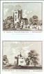
Author not known. Publication not known. c1830
Woodstock - Blenheim Palace. The construction of Blenheim Palace began in 1705, on land gifted to John Churchil, Duke of Marlborough, by a grateful nation in recognition of his victory at the Battle of Blenheim during the War of the Spanish Succession. Parliament voted funding for the build to which the Duke also contributed. The architect was Sir John Vanburgh and the house was mostly completed by 1725, in the English Baroque style. Quarrels between the Royal House household and the Marlboroughs, and between the Dutchess and the Architect contributed to the delay, causing disruptions to the flow of funding. The house remains the seats of the Dukes of Marlborough today, and is open to the public. This print, from an unknown source, shows a view of the palace from the gardens. It bears a faint signature, believed to be that of the engraver Samuel Rawle (1771-1860). An ex-library stamp to the lower right of the printed area could be hidden by judicious mounting.
Author not known. Publication not known. c1820-30
Woodstock - Blenheim Palace. The construction of Blenheim Palace began in 1705, on land gifted to John Churchil, Duke of Marlborough, by a grateful nation in recognition of his victory at the Battle of Blenheim during the War of the Spanish Succession. Parliament voted funding for the build to which the Duke also contributed. The architect was Sir John Vanburgh and the house was mostly completed by 1725, in the English Baroque style. Quarrels between the Royal House household and the Marlboroughs, and between the Dutchess and the Architect contributed to the delay, causing disruptions to the flow of funding. The house remains the seats of the Dukes of Marlborough today, and is open to the public. This print, from an unknown source, shows a view of the palace from the gardens. It bears a faint signature, believed to be that of the engraver Samuel Rawle (1771-1860). An ex-library stamp to the lower right of the printed area could be hidden by judicious mounting.
Oxford - Merton College Chapel from the Quadrangle. Memorials of Oxford was first published in 1837, though there were several later editions. It was a 3 volume work, with text written by James Ingram, and numerous steel engravings by John Le Keux after drawings by Frederick Mackenzie. Merton College was founded in the 1260's, and in 1266 was gifted the Parish Church of St. John to serve as its chapel. The church was in por repiar and had to be replaced by a new building on the same site around 1290. Extensions were added in the 14th and 15th centuries, and the church continued to act both as the college chapel and the parish church until 1891. Its huge east window is an important example of the later development of the Early English Style.
Oxford - The Martyrs' Memorial. Memorials of Oxford was first published in 1837, though there were several later editions. It was a 3 volume work, with text written by James Ingram, and numerous steel engravings by John Le Keux after drawings by Frederick Mackenzie. This print shows the frontage of St. John's College.
Author not known. Picturesque Europe c1887/8
Oxford - Trinty College, the Lime Walk. Picturesque Europe was a serialised partwork, designed as a showcase for steel and wood engravings after and by significant artists of the day. The 60 parts were published monthly from 1875 to 1880.When sets of parts were completed, they were also sold as complete volumes, building to a full 5-volume set, 2 volumes of which were devoted to the British Isles.This wood-cut print, engraved by W.H.J. Boot, shows the Lime Walk in the grounds of Trinity College.