J. Ellis Ellis's English Atlas 1766 (1765)
Isle of Man. Uncoloured. Map of Derbyshire printed on reverse.
J. Ellis Ellis's English Atlas 1766 (1765)
Isle of Wight. Joseph Ellis's English Atlas was an entry into the market for small county atlases by its publishers Robert Sayer and Carington Bowles. The county maps were closely based upon those drawn by Thomas Kitchin for the 1763 topographical work England Illustrated, the major difference being the attractive vignettes which replaced Kitchin's rococco cartouches. The atlas was first published in 1765, and soon became a commercial success, running to many later editions. It was promoted as a travelling atlas, and made available in various formats. These included a version with the maps printed back to back on each page, as with this example from a 1766 edition which has a map of Hertfordshire on the reverse.
J. Feltham A Guide to all the Watering and Sea-Bathing Places... 1803-1825
As the title suggests, this 500 plus page pocketbook provides a comprehensive guide to all the seaside resorts and spa towns popular with the fashionable upper and middle classes in the first quarter of the 19th century. The author was john Feltham, and the book was first published by R. Phillips in 1803. There were several updated and revised editions up to at least 1825. The work contained a number of small unattributed maps, including this one of the Isle of Wight.
The Beauties of England and Wales was a topographical partwork, issued in 18 volumes between 1801 and 1815. From 1804 a set of maps and town plans was gradually introduced to accompany the work. The maps were drawn by G. Cole and engraved by J. Roper, and were initially sold as a separate partwork series, before being collected together in 1810 and issued as The British Atlas. They were later also used in early editions of Dugdale's Curiosities of Great Britain, England and Wales Delineated. This copy is dated 1805, and would have been one of the first partwork issues. Original colour. Mounted.
Isle of Wight. Thomas Moule's antiquarian leanings are evident in his series of highly decorative county maps - a stylistic throwback in an age when cartographic work had become much plainer and more utilitarian. The maps were engraved by W. Smollinger, J. Bingley and J. Dower, and first appeared in Moule's English Counties Delineated, a partwork with text issued from 1830-32. They were subsequently made available as a complete work in 1837 under the same title, and were later re-issued in Barclay's Universal English Dictionary between 1842 and 1852. This latter work ran to several editions and the maps were often updated between editions to show the latest growth of the railway network. The Isle of Wight was given a separate map as well as being included on that of Hampshire. This example in modern colour is from one of the editions of Barclay's Dictionary between 1842 and 1852. Supplied mounted.
The Orkney & Shetland Islands/The Channel Islands/The Scilly Islands. Three maps on one sheet, covering some of the major island groups off the British coasts. The maps were drawn by Aaron Arrowsmith and engraved by Sidney Hall and the page is dated 1817, being from the first edition of Arrowsmith's New General Atlas, published that year.
Isle of Man. Thomas Moule's antiquarian leanings are evident in this series of highly decorative county maps - a stylistic throwback in an age when cartographic work had become much plainer and more utilitarian. The maps were engraved by W. Smollinger, J. Bingley and J. Dower, and first appeared in Moule's English Counties Delineated, a partwork with text issued from 1830-32. They were subsequently made available as a complete work in 1837 under the same title, and were later re-issued in Barclay's Universal English Dictionary between 1842 and 1852. This latter work ran to several editions and the maps were often updated between editions to show the latest growth of the railway network. The inclusion of the Isle of Man amongst a set of county maps was not usual by this date. This example in modern colour is from the 1848 edition of Barclay's Dictionary.
Jersey. A coloured manuscript map of Jersey marking the island's administrative divisions. Possibly a child's school project?
Britannia Depicta was one of 3 pocket-sized reductions of Ogilby's road book that appeared within an 18 month timeframe between 1719 and 1720. It was more innovative than the others in including much additional topographical and historical information (researched by John Owen) on the maps. The work was a commercial success and ran to many later editions. This map covers the main offshore islands belonging to the English crown. Mounted and ready for framing.
J. Rapkin British Colonies; their History, Extent, Condition and Resources c1851
The Channel Islands - Jersey & Guernsey. This attractive map of Jersey and Guernsey, drawn and engraved by John Rapkin, is best known from it's appearance in Tallis's Illustrated Atlas of the World, published in 1851. In this work it has the addition of a number of vignettes engraved in the blank sea areas. Tallis also used some of the atlas maps for another publication - British Colonies; their History, Extent, Condition, and Resources - published under the imprint of the London Printing and Publishing Company, also in 1851. This example is from this second work and lacks the vignettes - less attractive perhaps, but much the less common of the two states.
Isle of Wight. Through the latter half of the 18th century the firm of A. & C. Black published an increasingly wide range of guides to both overseas locations and parts of Great Britain. Their Guide to the Isle of Wight was certainly in print by 1872, though I have been unable to tie down its first date to issue. It included this small but detailed general map of the island drawn and engraved by Bartholomew's, and also covering the southern part of Hampshire. A repaired internal tear of c7 cms. but without loss and fairly unobtrusive.
Isle of Wight. First published in parts between 1863 and 1868, the completed National Gazetteer went on sale from 1868. The maps, which are produced by litho transfer from an intaglio plate, are amongst the earliest to feature printed colour. There were a number of later editions (some under different titles) up to 1886. Colouring became more sophisticated on these later editions. This example of the Isle of Wight map is from its first atlas issue in 1868.
Isle of Wight. Description de L'Univers was a small format 5 volume work with copperplate maps covering the whole world. This example is from the French text edition of 1683. A little worm damage to the outer lower-left margin, not affecting the image. Otherwise in nice condition. French text to verso is part of the description of London.
G. Bacon New Large Scale Ordnance Atlas of the British Isles 1883-8
Isle of Wight. This map was originally drawn for the Weekly Dispatch newspaper as part of a series published between 1857 and 1863. The subsequent history of the maps includes re-issues in The Dispatch Atlas in 1863, Cassell's Complete Atlas in 1863, Cassell's British Atlas in 1865, Bacon's County Atlas in 1869, and Bacon's New Large Scale Ordnance Atlas from 1883. There is no attribution to an individual author on the Isle of Wight map, but the series were drawn by E. Weller, J. Dower and B. R. Davies. All editions of the maps were by lithographic transfer. Original printed colour.
Isle of Wight. Although often ascribed to John Rocque, this map, by an unknown cartographer and engraver, first appeared in The English Traveller, a partwork published by Thomas Read between 1743 and 1745. The plates were later acquired by John Rocque, who re-issued the maps as The Small British Atlas in 1753. In 1769 around two thirds of the maps made a final appearance in England Displayed, a topographical work by P. Russell and O. Price. This example of the Isle of Wight map is probably from this latter work, based on the faint traces of an erased plate number outside the top right border.
R. Dawson Parliamentary Representation …. Reports from Commissioners on Proposed Division of Counties and Boundaries of Boroughs 1832
This map formed part of a Parliamentary Report, submitted in December 1831, showing proposed changes to electoral arrangements and boundaries which were subsequently enacted in the 1832 Reform Act. The report and maps were subsequently published for public consumption in 1832. Dawson was a Lieutenant in the Royal Engineers charged with survey and production of maps to illustrate the changes. Original colour.

Robert Laurie and James Whittle's road book was conceptually different from the Ogilby model of following just one major road from it's origin to its end destination. The publishers offered a work with 24 effectively, sectional maps, each covering the major road network in a given area. County borders, coasts,rivers, and major towns were plotted with their correct topographical relationships, but roads were mainly shown as straight lines linking the main towns. Although smaller towns and settlements along the roads were marked, their positioning on the map did not truly reflect their relative positions on the ground. Different types of roads were differentiated by how they were delineated. The maps were drawn and engraved by Nathanial Coltman, and the work was first published in 1806. There were a number of regular, later editions (with some additions and refinements) up to 1846. This example is plate 4 covering the Isle of Wight's road network local distances being shown from Newport. It is dated 1806, and is thus from the first edition of the work.
H. Moll The Geography of England / H. Moll's British Atlas 1747 or 1753 (1724)
Moll's set of English and Welsh county maps were first published in 1724 in two formats - with descriptive text as a topographical work, and without text as an atlas. The latter format clearly proved more popular, as later editions included maps alone. Most maps carried illustrations of local antiquities or sights outside their borders, but the map of the islands never enjoyed such embellishments, probably because it required the extra page width to accommodate the small maps of the Scilly Isles and Holy Island, beside the main map of the Isle of Wight. This example is from the editions of 1747 or1753, so identified by the change in plate numbers, the Isle of Wight etc. map now becoming plate 18 (previously plate 9).
R. Dawson Parliamentary Representation …. Reports from Commissioners on Proposed Division of Counties and Boundaries of Boroughs 1832
Isle of Wight. This map formed part of a Parliamentary Report, submitted in December 1831, showing proposed changes to electoral arrangements and boundaries which were subsequently enacted in the 1832 Reform Act. The report and maps were subsequently published for public consumption in 1832. Dawson was a Lieutenant in the Royal Engineers charged with survey and production of maps to illustrate the changes. Original colour.
S. Hall A New British Atlas 1833 or 1834 (1831)
Jersey, Guernsey and the Isle of Man. First published by Chapman and Hall in 1831 in John Gorton's A Topographical Dictionary of Great Britain and Ireland, and subsequently in A New British Atlas and in A Travelling County Atlas with lithographic transfers until 1875. This copy of the Islands of Jersey, Guernsey and Man is dated 1832, which dates it to the early 1833 or 1834 editions of the New British Atlas.
J. Dower Hampshire, Its Past and Present Condition, and Future Prospects 1838
Robert Mudie's history of Hampshire was published in 1838, and included a small number of maps by John Dower, including this one - suprisingly of the Channel Islands. Later colour and an uncommon item.
Philip's Handy Atlas was first published in 1873, with maps produced by lithographic transfer and drawn by John Bartholomew and Co. There were many later editions of the work, this example being from the edition of 1882. Printed colour.

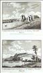
Carisbrook Castle, Isle of Wight. England Displayed was a topograhical partwork, first published in April 1769, and comprising 80 weekly part. It was designed to grow into 2 volumes, with each receiving a title page as completed. When all 80 parts had been issued the series could also be purchased as a complete work. The publishers were P. Russell, O. Price and J. Coote, and it comprised 81 topographical prints and 54 maps, plus some 700 pages of text. Carisbrooke Castle existed by 1100 when it was in the possession of Richard de Redvers, but forts existed on the site in both Roman and Saxon times. The castle was purchased by King Edward I in 1293, since when it has been a crown property controlled by a Warden. King Charles 1 was imprisoned there in 1648/9 prior to his trial and execution, and in more recent times it was home to Queen Victoria's daughter, Princess Beatrice from 1896-1944. It is today maintained by English Heritage who open it to the public. This print bears no signatures of author or engraver.
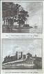


West Cowes Castle & Carisbrooke Castle. The New British Traveller was one of a number of publications by Alexander Hogg aiming to tap the bouyant market for works on British topography and antiquities. It included text on each couny, a set of county maps by T. Conder and others, and numerous copperplate prints by a variety of engravers. The work was initially issued in 60 parts from c1783, and then as a complete work from 1784. West Cowes Castle is one of 2 forts built by Henry VIII in 1539 to guard the mouth of the River Medina. In 1716 the fort was remodelled for residential use, and further adapted in 1856-8 as the Club House for the Royal Yacht Squadron, which it remains today.
Carisbrooke Castle existed by 1100 when it was in the possession of Richard de Redvers, but forts existed on the site in both Roman and Saxon times. The castle was purchased by King Edward I in 1293, since when it has been a crown property controlled by a Warden. King Charles 1 was imprisoned there in 1648/9 prior to his trial and execution, and in more recent times it was home to Queen Victoria's daughter, Princess Beatrice from 1896-1944. It is today maintained by English Heritage who open it to the public. This print offers 2 views on 1 sheet, which could be separated for individual mounting if desired. A little marginal foxing would be hidden by a mount.
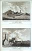
Carisbrooke Castle, Isle of Wight. The Antiquities of England and Wales was the product of Alexander Hogg who was well known as a partwork publisher. Under the claimed authorship of Henry Boswell it was issued serially from c1787-9, and subsequently made available as a complete work. The format was typically 2 (though sometimes up to 6) prints to a page, with one or two accompanying pages of descriptive text on each pair of subjects. It also included the set of English county maps by Thomas Kitchin first used in the London Magazine from 1747-54. Carisbrooke Castle existed by 1100 when it was in the possession of Richard de Redvers, but forts existed on the site in both Roman and Saxon times. The castle was purchased by King Edward I in 1293, since when it has been a crown property controlled by a Warden. King Charles 1 was imprisoned there in 1648/9 prior to his trial and execution, and in more recent times it was home to Queen Victoria's daughter, Princess Beatrice from 1896-1944. It is today maintained by English Heritage who open it to the public. This print, engraved by Neigel, offers 2 views on 1 sheet, and is supplied with the original, accompanying text.
Carisbrooke Church. The Antiquities of England and Wales was the product of Alexander Hogg who was well known as a partwork publisher. Under the claimed authorship of Henry Boswell it was issued serially from c1787-9, and subsequently made available as a complete work. The format was typically 2 (though sometimes up to 6) prints to a page, with one or two accompanying pages of descriptive text on each pair of subjects. It also included the set of English county maps by Thomas Kitchin first used in the London Magazine from 1747-54. The parish church of St. Mary's was built in the first quater of the 12th century. Towards the end of the century it became a conventual church, with the addition of a small Benedictine Priory. The Priory was later supressed by King Henry V in 1415, and the buildings were pulled down, leaving only the church, which underwent major restoration in 1914. This print was engraved by Sparrow - a couple of marginal spots.
Author not known. The "Garden Isle" Series of Views c1880
Carisbrooke Castle, Isle of Wight. This is not an engraving or wood cut, but an original photographic print. The photo is mounted on card which carries the statement that it was part of "The Garden Isle" series of views and sold by J. Briddon, Ventnor. James Briddon was a self-made Victorian entrepreneur, born in 1827, who came to the Isle of Wight around 1851. He started off in Ryde where he sold and published books and prints, and founded the Isle of Wight Mercury newspaper. Around 1863 he purchased the Esplanade Bazaar in Ventnor from where he carried on his previous activities, but also diversified into the new and up-and-coming field of photography, creating various photographic souvenirs for the tourist trade. He died in 1894. This photograph shows the entrance gateway to Carisbrooke Castle, and is tentatively dated to c 1880.

Jersey - St. Hilary. The New British Traveller was one of a number of publications by Alexander Hogg aiming to tap the bouyant market for works on British topography and antiquities. It included text on each couny, a set of county maps by T. Conder and others, and numerous copperplate prints by a variety of engravers. The work was initially issued in 60 parts from c1783, and then as a complete work from 1784. St. Hilary is one of the 12 parishes of Jersey, and covers the majority of St. Helier, the islands largest town, which was once known by the parish name. The origins of the two alternative spellings are somewhat confused. One suggestion is that St. Helier was a martyred hermit living on the island in the first millenium, and his name was corrupted to "St. Hilary". An alternative version suggests a linkage with St. Hilary, Bishop of Poitiers, with the parish church being dedicated in his honour. The corruption of the names would then be in the reverse order. This print shows a view of the town from the sea, and was probably taken from Elizabeth Castle, which lies on an offshore islet in the bay. A little marginal foxing, which could be hidden by judicious mounting.

Guernsey - St. Sampson's Castle. The Antiquities of England and Wales was the product of Alexander Hogg who was well known as a partwork publisher. Under the claimed authorship of Henry Boswell it was issued serially from c1787-9, and subsequently made available as a complete work. The format was typically 2 (though sometimes up to 6) prints to a page, with one or two accompanying pages of descriptive text on each pair of subjects. It also included the set of English county maps by Thomas Kitchin first used in the London Magazine from 1747-54. I am assuming this print, named as St. Sampson's Castle is actually Vale (or St. Michael's) Castle, which lies on a promontory to the north of the town and its harbour. The earliest parts of the castle date from the 15th century, though some early Iron Age earthworks have also been found on the site. The Castle was apparently abandoned to decay some time around 1680, but later restored in the 1780's when a new barracks block was built. The barracks was demolished under the island's WWII occupation, but the castle remains are open to the public today. This anonymous print is supplied with the original, accompanying text.

Elizabeth Castle (Jersey), St. Michael's Castle (Guernsey), Lundy Castle, Caerphilly Castle (Glamorgan), Beaumaris Castle (Anglesea) & Minster Monastery (Sheppey). The Antiquities of England and Wales was the product of Alexander Hogg who was well known as a partwork publisher. Under the claimed authorship of Henry Boswell it was issued serially from c1787-9, and subsequently made available as a complete work. The format was typically 2 (though sometimes up to 6) prints to a page, with one or two accompanying pages of descriptive text on each pair of subjects. It also included the set of English county maps by Thomas Kitchin first used in the London Magazine from 1747-54. This anonymous print offers 6 views on 1 sheet (mostly of castles) with 2 being of Channel Islands interest. Elizabeth Castle stands on an offshore islet in St. Aubin's Bay, protecting the town and harbour of St. Helier. It's construction began in the late 16th century and it was named in honour of Queen Elizabth I by Sir Walter Raleigh, who was Governor of Jersey from 1600-1603.It is today a museum and tourist attraction administered by Jersey Heitage. St. Michael's or Vale Castle lies on a promontory to the north of the town and harbour of St. Sampson. The earliest parts of the castle date from the 15th century, though some early Iron Age earthworks have also been found on the site. The Castle was apparently abandoned to decay some time around 1680, but later restored in the 1780's when a new barracks block was built. The barracks was demolished under the island's WWII occupation, but the castle remains are open to the public today. The print is supplied with the original, accompanying text.

Peele Castle, Isle of Man. The New British Traveller was one of a number of publications by Alexander Hogg aiming to tap the bouyant market for works on British topography and antiquities. It included text on each couny, a set of county maps by T. Conder and others, and numerous copperplate prints by a variety of engravers. The work was initially issued in 60 parts from c1783, and then as a complete work from 1784. Peel Castle stands on St. Patrick's Isle which has a causeway connection to the town of Peel.The first structure on the island was the Celtic monastery of St. Patrick, built sometime in the 10th century. Magnus Barefoot, King of Mann is believed to have built the first castle in the 11th century, incorporating part of the monastery, notably the surviving round tower. Most of the other extant castle remains date from the early 14th century. Within the castle precinct are the ruins of the cathedral of St. German, built in stages between the 12th and 14th centuries, but later abandoned to decay from the 18th century. The site is today maintained by Manx National Heritage and open to the public. This print has a little light foxing to the margins, which would be hidden by a mount.

Castle Rushin (Rushen), Castletown, Isle of Man. The Antiquities of England and Wales was the product of Alexander Hogg who was well known as a partwork publisher. Under the claimed authorship of Henry Boswell it was issued serially from c1787-9, and subsequently made available as a complete work. The format was typically 2 (though sometimes up to 6) prints to a page, with one or two accompanying pages of descriptive text on each pair of subjects. It also included the set of English county maps by Thomas Kitchin first used in the London Magazine from 1747-54. Castle Rushin stands in a central position in Castletown, the historic capital of the Isle of Man. The first timber castle on the site was probably constructed in the 9th centry AD, with later rebuilding in stone and additions from the 13th to the 16th centuries. It was originally a possession of the Kings of Mann, and subsequently fought over by the Scots and English, changing hands several times. After 1660 its densive importance reduced, and it fell into decay, though still used as a prison, until it was restored in the late 19th century. It has been owned by Manx National Heritage since 1988, and is open as a heritage centre and museum. This print, engraved by Peltro, is supplied with the original, accompanying text. A few spots - mostly to the margins - which would be hidden by a mount.
St Patrick's Church & St Germain's Cathedral at Peel Castle, Isle of Man. The Antiquities of England and Wales was the product of Alexander Hogg who was well known as a partwork publisher. Under the claimed authorship of Henry Boswell it was issued serially from c1787-9, and subsequently made available as a complete work. The format was typically 2 (though sometimes up to 6) prints to a page, with one or two accompanying pages of descriptive text on each pair of subjects. It also included the set of English county maps by Thomas Kitchin first used in the London Magazine from 1747-54. The remiains of St. Patrick's Church and St. German's Cathedral both stand within the precints of Peel Castle, located on St. Patrick's Isle which has a causeway connection to the town of Peel.The first structure on the island was the Celtic monastery of St. Patrick, built sometime in the 10th century. Magnus Barefoot, King of Mann is believed to have built the first castle in the 11th century, incorporating part of the monastery, notably the surviving round tower. Most of the other extant castle remains date from the early 14th century. Within the castle precinct are the ruins of the cathedral of St. German, built in stages between the 12th and 14th centuries, but later abandoned to decay from the 18th century. The site is today maintained by Manx National Heritage and open to the public.

Holy Island. The Antiquities of England and Wales was the product of Alexander Hogg who was well known as a partwork publisher. Under the claimed authorship of Henry Boswell it was issued serially from c1787-9, and subsequently made available as a complete work. The format was typically 2 (though sometimes up to 6) prints to a page, with one or two accompanying pages of descriptive text on each pair of subjects. It also included the set of English county maps by Thomas Kitchin first used in the London Magazine from 1747-54. The island of Lindisfarne (or Holy Island) lies 1 mile off the north Northumbrian coast, and joined to the mainland at low tide.It has two notable buildings - a Priory and a Castle. The Priory was founded there by St. Aidan in 634 AD, and under St. Cuthbert became a leading centre for learning and the Christian faith, producing such works as the still surviving Lindisfarne Gospels. The monks fled the island in 878 after attacks by the Vikings and Danes, but the Priory was re-established in 1093, and continued until the dissolution of the monasteries, after which the buildings decayed. The ruins are today in the care of English Heritage and open to the public. The Castle was built in the mid 16th century as part of the coastal defences against the Scots. In 1901 it was bought by Edward Hudson, who employed Lutyens to refurnish it in the Arts and Crafts style. It is today maintained by the National Trust and opened to the public. This print, engraved by Peltro, is supplied with the original, accompanying text from the work.