J. Blaeu Theatrum Orbis Terrarum 1645-72
The Blaeu family were one of the leading Dutch map producers of the 17th century. Their major work was a multi volume world atlas initiated by Willem Blaeu and expanded by his son Joan. Their maps were beautifully designed and engraved, and are often found with original colour, making them most desirable to collectors. 1645 saw the first publication of volume 4 of the atlas, containing maps of England and Wales. There were several re-issues between then and 1672 when most of Blaeu's plates were lost in a fire which engulfed his Amsterdam premises. This example is in original full colour. Some repaired marginal tears, of which one expertly repaired at bottom margin impinges the printed area. A superby fresh example on japanned paper. No text on verso.
In the mid 17th century the Amsterdam-based Jansson and Blaeu families were in fierce competition, each seeking to top the other in extending and updating their multi-volume world atlas projects. Jansson was the first to introduce maps of some individual English counties in 1636,only for Blaeu to leap frog him in 1645 with a new volume covering all of England and Wales, and with more decorative map designs. Jansson responded swiftly, re-engraving his existing English county maps and completing the series in time to introduce his own new volume on England and Wales in 1646. Original colour. Mounted ready to frame.
This small county atlas of England and Wales was first issued in 1748 by a consortium of 7 publishers who also had a stake in the publication of Daniel Defoe's Tour Through the Whole Island of Great Britain. It was advertised as a companion volume to Defoe's work, or as a pocket atlas in its own right. Thomas Hutchinson's name appears as the engraver on 2 maps, but the rest are unsigned and may be by a variety of hands. They are sometimes also known as Osborne/Wale maps. There was a second edition in 1756. Repaired tear to lower centrefold.
In 1695 John Seller published a county atlas titled Anglia Contracta. The plates were much later acquired by Francis Grose, revised, and used in a supplement to his partwork on British antiquities. The supplement with maps was first published in 1787, and ran to several later editions. Modern colour, with descriptive text below and to verso.
T. Kitchin The Antiquities of England and Wales c1789 (1748)
This map was first published in the January 1748 edition of the London Magazine, which between 1747 and 1754 issued a complete set of English county maps by Thomas Kitchin. The maps were later re-published by Alexander Hogg in Boswell's Antiquities of England & Wales, initially in partwork from c 1787-9, and then in several complete editions of the work up to 1798. This example of the Suffolk map is from the first complete edition of Boswell's Antiquities dating from c1789. Supplied ready mounted, and with the original accompanying text on the county.
John Aikin (or Aiken) wrote this topographical work for children in order "to make my young countrymen better acquainted than they are usually found to be with their native land". The first edition of 1788 did not include county maps, but these were added for the second edition of 1790, from which this example comes. The work was published by Joseph Johnson, but the maps are unsigned. There were four later editions of the book with the maps, and one without. The Suffolk map is fairly simple, befitting the needs of its target audience, and the text may be available at no extra charge.
J. Lodge Untitled Atlas of the English Counties c1795
This was one of a set of county maps engraved by John Lodge and issued between 1787 and 1790 in The Political Magazine, and Parliamentary, Naval, Military and Literary Journal, published initially by John Murray, and later by R. Butters. The maps were subsequently collected together and re-issued as an atlas (without title page) around 1795. For this atlas edition the imprint with the publication date and engraver's and publisher's signatures was removed from the maps. This example is from the atlas edition. The maps are well engraved in the plainer style then coming into vogue. They are uncommon, and sought by collectors.
J. Cary New English Atlas 1811 (1809)
It is suprising that Cary's large county atlas was issued as late as 1809, as individual maps from it seem to have been sold singly from 1801. The atlas format was perhaps to compete with the similarly sized atlas of Charles Smith, which went under the same title and was published in 1804. It is perhaps Cary's finest production, the maps being notable for their fine design, detail and engraving. The atlas ran to several later editions by Cary, and the plates were later used for a variety of lithographic transfers by G.F. Cruchley. This example is from the second edition of 1811, and is in original full colour.
G. Cole J. Roper Curiosities of Great Brtiain, England and Wales Delineated 1835 or 1838 (1804-10)
This set of maps, drawn by G. Cole and engraved by John Roper, were first issued in parts between 1804 and 1810, together with a number of town plans. They were subsequently collected together to form The British Atlas, issued in 1808 as a companion volume to The Beauties of England & Wales, written by J. Nightingale. The maps were further re-issued in 1816 in English Topography, (also written by Nightingale). and again in Dugdale's Curiosities in Great Britain from 1835. The symbols for polling places on this example of the Suffolk map indicates that it is from the 1835 or 1838 editions of Dugdale's Curiosities...Modern colour. Narrow vertical margins but sufficient for mounting.
G. Gray Gray's New Book of Roads 1824
This map appeared in a number of publications by Charles Cooke from c1810 to 1830. This example is from Gray's New Book of Roads, published in 1824, in which a plate number was added to the map for the first time.
This entry into the popular market for miniature atlases and road books was first published by Samuel Leigh in 1820 under the title Leigh's New Pocket Atlas of England and Wales. The maps were engraved by Sidney Hall. There were several later editions up to 1843, under slightly changed titles and imprints. From some time in 1831 the imprint changed to that of M.A. Leigh at 421 Strand, and this example dates from this latter period.
J. Duncan A Complete County Atlas of England and Wales 1840-45 (1825)
Coloured. These maps were first published in 1825, and probably sold singly. In 1833 they were re-published by James Duncan in a thematic atlas to illustrate the representative changes brought about by the 1832 Reform Act. There were later re-issues in 1840 and 1845 with the addition of railways, and this map dates from one of these editions.
This map, drawn and engraved by Samuel Neele, was used in James Dugdale's New British Traveller, and (with a changed imprint) in Robins' Atlas of England and Wales. Both works were published in 1819. This example is from Robin's Atlas, though the map imprint bears the date 1818.
J. Gibson New and Accurate Maps of the Counties of England and Wales 1759-c1779
A nice example of an uncommon miniature map.
The Agreeable Historian was a weekly partwork, intended to be bound into 3 volumes when completed. It was issued in 109 parts beween December 1743 and December 1745, with the final title page being dated 1746. The work was a topographical review of the counties of England, being published by R. Walker, with Samuel Simpson cited as the author.
Chorographia Britanniae was one of the most popular 18th century atlases, offering county maps showing main roads, a handy pocket-size format and useful extra information provided in the notes. Maps from fhe first edition published in 1742 (but with maps dated 1741) initially had sparse topograhical information, but within a few months a second edition was issued in which the maps were re-engraved to include many more towns and villages. This example is from this second edition. Several later re-issues followed and the work continued to be advertised until at least 1759. Modern colour.
J. Seller Camden's Britannia Abridged 1701 (c1695)
First published in Anglia Contracta in c 1695, Seller's maps were subsequently reissued in A History of England in 1696, and in Camden's Britannia Abridged in 1701. They were later re-used in the 1780's in Grose's Antiquities of England and Wales, for which titles and scale-bars were changed, the maps also being set in a page of text. The Seller/Grose maps are common, the originals by Seller are not.
James Pigot & Co's county maps were issued in their British Atlas (from c1829), in several of their national and local business directories (from at least 1826 for the "home counties"), and singly in folding form as travelling maps. They were amongst the first maps to be printed from steel instead of copper plates, allowing more accurate fine detail and less wear to the plates over time. Atlas and directories went through several editions up to around 1857, later editions from 1846 being re-named Slater's New British Atlas, with imprints changed accordingly. This example is from the 1839 edition of the atlas, so dated from Pigot's Fleet Street address. Original outline colour.
A. Fullarton Bell's New and Comprehansive Gazetteer of England and Wales 1834
This map was first published in partwork by Fullarton and Co. in 1833-34 in James Bell's New and Comprehensive Gazetteer of England and Wales. The complete work was subsequently re-issued three times in 1834, 1836 and 1837. They were later re-published (again by Fullarton) in 1840 in The Parliamentary Gazetteer of England and Wales, with several further re-issues up to 1849. The maps were engraved on steel and sometimes bear the name of the engraver and sometimes not. This example is from the 1834 edition of Bell's Gazetteer and bears the signature of R. Scott as engraver. The attractive vignette shows the view of Yarmouth from the Roads. Modern colour. Supplied mounted and ready for framing.
Mr. Muir's Hunt. These hunting maps, engraved by John Dower for M.A. Pittman, originally appeared in the Sporting Review magazine in the early 1840's. The full set of 24 maps were also issued as The Fox Hunter's Atlas in c1843 and c1850. A later issue of the atlas in c1857 had 28 maps. Individual folding examples have also been found in red silk covers.The maps are based on the territory of each hunt irrespective of county borders.This example shows Mr. Muir's hunt, covering parts of Suffolk and Cambridgeshire. Modern colour.
J. Pigot A Pocket Topography and Gazetteer of England 1841
Published by Pigot and Slater in 1841 as a pocket gazetteer of the English counties, though some counties may have been available slightly earlier on a partwork basis. The map is in original outline colour, and is supplied with the 26 text pages relating to the county. Some browning.
This work was published in 1835 as a companion volume to Lewis's Topographic Dictionary. It contains county and borough maps, drawn by R. Creighton and engaved by J.& C. Walker, and was designed to show the electoral and boundary changes effected by the 1832 Reform Act. There were 2 issues of the work in 1835 and 1840, this example of the county map being from the 1835 first edition. Original outline colour.
Cowley's Suffolk map was one of a set of 52 maps of the English and Welsh counties issued in a topographical work, The Geography of England. The book was published by R. Dodsley, and its title page is dated 1744, though other evidence suggests an actual publication date of November 1743. The 52 maps were re-issued in 1745 and 1748 as a county atlas without text under the title A New Sett of Pocket Maps of all the Counties of England and Wales. The maps are uncommon. Tight left-hand margin. Supplied ready mounted.
These maps were drawn and engraved by John Emslie, and first published in 1848 as Reynolds Travelling Atlas of England. In 1860 geological data was added and the maps were re-issued as Reynolds Geological Atlas of Great Britain. There were later editions of the Geological Atlas in c1864 (when the maps were first issued geologically coloured), and in c1867, c1869 and 1889. Editions from 1864 were by lithographic transfer from the original intaglio plate. This example, in original hand-colour, dates from 1864 or later.
Between 1832 and 1834 Joshua Archer engraved a set of maps for the serialised partwork Pinnock's Guide to Knowledge. The maps were unusual in being relief printed from wooden blocks to give a "white on black" presentation. In 1847 amended versions of the maps were re-issued in Thomas Johnson's county atlas. Various changes were made to the wood blocks (including a new "piano key" border, and the addition of railways), and printing was by lithographic transfer to give a more conventional and easier to read "black on white" presentation. The amended maps from Johnson's atlas are today something of a rarity. This example is in original wash colour and in nice condition. Supplied mounted.
This miniature map was first published by J. Thomson in 1823 in The New English Atlas. It was subsequently re-issued by Orlando Hodgson in 1827 in The Pocket Tourist and English Atlas. It is uncertain which work this example comes from, but both are uncommon. A repaired internal, short tear (just visible to the left of Aldborough) without loss.
S. Hall Excursions in the County of Suffolk 1818
This topographical work on Suffolk was published in 1818, with text by Thomas Cromwell, and a county map by Sidney Hall. Companion volumes were also published for some other counties (e.g. Norfolk).
P. Meijer Algemeene Oefenschoole Van Konsten En Weetenschappen 1763
This Dutch topograhical work on England and Wales is a close translation of Benjamin Martin's The Natural History of England. The county maps included are also copied from those of Emanuel Bowen in Martin's work. Whether this should be regarded as plagiarism or a joint commercial arrangement is uncertain. The work was probably published serially (as individual maps are variously dated between 1757 and 1770), and later collected into two volumes. The engraving was by L. Schenk. Sales of the work were probably poor, as the maps are amongst the rarest of English county maps today, and eagerly sought by collectors.
The Blaeu's major sea Atlas, Der Zeespiegel, was first published in 1623, and was re-issued a number of times in both Dutch and English editions between 1623 and 1652. From 1655-66 it was re-issued in an expanded edition as De Groote Zeespiegel. This example is from a Dutch edition and traces the Norfolk and Suffolk coasts from Cromer to Orfordness. Despite the several original editions, the charts are today rare.
Miller's miniature county atlas was undated, but issued in c 1821. There were re-issues in c 1822 and 1825 under the imprints of William Darton, who presumably bought the publishing rights from Miller. This example is from the first edition by Miller. An uncommon map.
Ordnance Survey Ordnance Survey - Sheet 77 Popular Series - Lowestoft and Waveney Valley 1933 (1921)
Sheet 77 of the 1 inch popular series which was first published in 1921. A folding, linen-backed map covering north-east Suffolk and south-east Norfolk. Lacking the card covers. First published 1921 but this example corrected to 1933. A little wear along folds.
Britannia Depicta was one of 3 pocket-sized reductions of Ogilby's road book that appeared within an 18 month timeframe between 1719 and 1720. It was more innovative than the others in including much additional topographical and historical information (researched by John Owen) on the maps. The work was a commercial success and ran to many later editions the last in 1764. Modern colour.
E. Bowen The General Magazine of Arts and Sciences/The Natural History of England 1759
This map first appeared in the June 1759 number of Benjamin Martin's General Magazine of Arts and Sciences, a monthly partwork which between 1755 and 1762 included a series of county maps. The magazine's format was novel, each issue covering 5 (later 6) subject areas. The intention was that all those parts relating to any one subject could later be rebound into subject volumes, for which individual title pages would be issued. In 1763 title pages for a two volume set were issued for those parts relating to natural history. Subscribers could then, if so desired, rebind their original partworks, and new purchasers could purchase the completed work under the title, The Natural History of England. There were no later re-issues and the maps are today not common. Supplied ready-mounted.
Laurie's Travellers Companion was first published as a road atlas in 1806 by Laurie and Whittle. It included ? regional maps by Nathaniel Coltman featuring the main road network as a series of straight lines linking towns en-route.There were a number of later editions, this example being from that of 1815.
W. Cobbett A Geographical Dictionary of England and Wales 1832 or 1854
William Cobbett is probably best known for his work Rural Rides dealing with rural depopulation, but also entered the market for topographical dictionaries, publishing A Geographical Dictionary of England and Wales in 1832. The work contained a set of very sketchy and simplistic county maps. There was a second edition in 1854, but neither seems to have sold well as today Cobbet's maps are rarely encountered.
First published by Pinnock and Maunder in 1820, this work was subsequently acquired by G. and W.B. Whittaker, who republished it in 1821 and 1823. This example is from one of these editions. The same maps also appeared in Pinnock's County Histories in 1829, 1823 and 1825. Original wash and outline colour.
This Philips' Atlas was first published c1862 with further issues up to 1891. All editions were by lithographic transfer. The maps were drawn and engraved by Bartholomews, and printed colour was introduced to later editions, as with this example, to represent Parliamentary Divisions.
Originally intended as volume 3 of a larger cartographic project (The English Atlas), Richard Blome's Britannia was published alone in 1673. A rare second edition was issued in 1677. This Suffolk map is from the first edition of the work, and was dedicated to Thomas Timperley of Hintlesham Hall (today a hotel). In return for his patronage of Blome's project Timperley received this dedication on the county map, and also appeared in the list of the nobility and gentry of the county, his coat of arms being further included amongst the 816 illustrated in the volume.
T. Crabb A Unique Card-Mounted Map of Suffolk c1819
Miller's miniature county atlas is undated but believed to have been published around 1821. The maps in the Atlas bear Miller's imprint as the publisher, and have plate numbers. In 1986, however, a part set of these maps was found mounted onto cards, without plate numbers and with the publisher's imprint of T. Crabb. Their intended use is uncertain - possibly part of a children's game, or for advertising or promotional purposes - but the card mounts are contemporary. One of the cards was also dated 1819 - rather earlier than the assumed publication date for the atlas. The set are now in a private collection.This card of Suffolk was not included in the set described above, and is believed to be an extremely rare or unique item.
S. Hall A Topographical Dictionary of Great Britain and Ireland 1832
This set of maps was first published in 1831 in A Topographical Dictionary of Great Britain and Ireland by John Gorton. They were later re-issued, with various amendments, in several other works including Hall's New British Atlas (1833-36) and A Travelling County Atlas (1842-1875). This is an early example of Sidney Hall's map, as it bears the date 1832 - suggesting either that it comes from the second edition of the Dictionary in 1833, or that the generally accepted first publication date of 1831 was actually the following year. A few light brown marks.

Alderton Church. The Antiquities of England and Wales was the product of Alexander Hogg who was well known as a partwork publisher. Under the claimed authorship of Henry Boswell it was issued serially from c1787-9, and subsequently made available as a complete work. The format was typically 2 (though sometimes up to 6) prints to a page, with one or two accompanying pages of descriptive text on each pair of subjects. It also included the set of English county maps by Thomas Kitchin first used in the London Magazine from 1747-54. Alderton is a small village about 6 miles noth of Felixstowe. The partially ruined church of St. Andrew is interesting and picuresque. The oldest parts of the church date from the 14th century and the tower was built in the 15th century, but apparently not very well. It progressively collapsed to its current height and state of ruination from the 17th century up to 1821. With no tower, the church bell is today mounted on a wooden framework in the churchyard. The rest of the church was restored by the Victorians. This print, engraved by Noble, is supplied with the original, accompanying text.

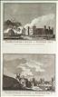
Cardinal Wolsey's College, Ipswich. The Antiquities of England and Wales was the product of Alexander Hogg who was well known as a partwork publisher. Under the claimed authorship of Henry Boswell it was issued serially from c1787-9, and subsequently made available as a complete work. The format was typically 2 (though sometimes up to 6) prints to a page, with one or two accompanying pages of descriptive text on each pair of subjects. It also included the set of English county maps by Thomas Kitchin first used in the London Magazine from 1747-54. Cardinal Wolsey came from Ipswich and attended the local small grammar school. In 1528 work began on a new Grammar School in the town, intended by Wolsey as a feeder to his recently founded Cardinal College in Oxford. Unfortunately the school was unfinished by the time of Wolsey's fall in 1830, and most of what had been built was demolished, though the school was later refounded by King Henry VIII and survives today as Ipswich School on a different site. The original site of Wolsey's College passed into private hands, and today only one gateway of the original complex survives, known locally as "Wolsey's Gate".
Orford Castle. The Antiquities of England and Wales was the product of Alexander Hogg who was well known as a partwork publisher. Under the claimed authorship of Henry Boswell it was issued serially from c1787-9, and subsequently made available as a complete work. The format was typically 2 (though sometimes up to 6) prints to a page, with one or two accompanying pages of descriptive text on each pair of subjects. It also included the set of English county maps by Thomas Kitchin first used in the London Magazine from 1747-54. Orford Castle was built by King Henry II beween 1165 and 1173, as a check on the power of the local and rebelliously-inclined Bigod family. In 1336 it passed into private hands under the ownership of the Earls of Essex, but gradually fell into the decayed state shown on this print, with only the unusual keep surviving. Today it is owned and managed by English Heritage, who open it to the public. This print was engraved by Noble.
Framlingham Castle. The Antiquities of England and Wales was the product of Alexander Hogg who was well known as a partwork publisher. Under the claimed authorship of Henry Boswell it was issued serially from c1787-9, and subsequently made available as a complete work. The format was typically 2 (though sometimes up to 6) prints to a page, with one or two accompanying pages of descriptive text on each pair of subjects. It also included the set of English county maps by Thomas Kitchin first used in the London Magazine from 1747-54. Framlington Castle was built by the Bigod family at an uncertain date in the 12th or 13th centuries, possibly on the site of a previous castle. It has had a chequered history, being owned at various times by the Crown, and a succession of noble families, including the powerful Mowbrays and then the Howards in the 15th and 16th centuries. In 1636, by which time it was much decayed, it passed to Pembroke College, Cambridge, and in the 17th and 18th centuries poorhouses were built within the walls. The Castle was gifted to the Ministry of Works in 1913, and is today maintained and opened to the public by English Heritage. This print, engraved by Noble, offers 2 views on 1 sheet, and is supplied with the original, accompanying text.

Bliburgh Priory & Arwerton Hall, Suffolk, Weymouth Castle, Dorset & Rougemont Castle, Exeter. The Antiquities of England and Wales was the product of Alexander Hogg who was well known as a partwork publisher. Under the claimed authorship of Henry Boswell it was issued serially from c1787-9, and subsequently made available as a complete work. The format was typically 2 (though sometimes up to 6) prints to a page, with one or two accompanying pages of descriptive text on each pair of subjects. It also included the set of English county maps by Thomas Kitchin first used in the London Magazine from 1747-54. This anonymous print offers 4 views on 1 sheet, 2 of which are of Suffolk interest. Bilbrough (or Blythburgh) Priory, was a smallish outlying cell of St. Osyth's Priory in Essex. Its ruins still stand in the grounds of a private house c4miles south of Southwold. Arwerton (or Ewarton) Hall an Elizabethan house built by Philip (later Sir Philip) Parker some time after he inherited the Arwerton estate in 1551..By the time of this print the house was ruinous, but interest was still attracted by the unusual Tudor gateway here shown. The house was rebuilt around the surviving ruins in 1858, and stands today. Sir Philip was an uncle of Anne Boleyn and is said to have buried her heart in Ewarton Church after her execution. Supplied with the original, accompanying text.