W. Hole Camden's Britannia 1637 (1607)
East Riding. The first five editions of Camden's successful history and topography of Britain were without maps, but for the sixth edition of 1607 the engravers William Hole and William Kip were commissioned to provide a set of maps of the counties of England and Wales, plus 3 general maps of the countries comprising the new "United Kingdom". These maps were retained for the subsequent 1610 and 1637 editions. They are based on the earlier work of Saxton, Norden, Smith and Owen. This attractively coloured example is from the 1637 edition.
J. Speed Theatre of the Empire of Great Britain 1612-1654
Whole county. John Speed's maps of the English and Welsh counties are amongst the most decorative of early, British cartographic work, and are eagerly sought after today. They were first published in 1612 in The Theatre of the Empire of Great Britaine, designed as a companion volume to Speed's History of Great Britaine. The maps were based on the earlier surveys of Saxton, Norden and a few others, with engraving contracted to Jodocus Hondius whose signature appears on 33 of the maps. Speed's greatest innovation was the inclusion of inset plans of major towns and cities. Although some were copied from earlier work, for many towns this was first plan ever published. Speed's county atlas was re-issued a number of times for a period of around 160 years, with new publishers making various small changes and updates to the maps over time. This is an early and most attractively coloured example of the Yorkshire bearing the imprint of Sudbury & Humble, dating it to 1612-54. A narrow right-hand vertical margin, and a small repair to a short internal tear without loss.

West Riding. Jan Jansson was one of Amsterdam's leading 17th century mapmakers, and a close rival to the Blaeu family. His multi-volume world atlas first saw the introduction of 6 maps of individual English counties into the German edition of 1636, and a further 11 of English and Welsh counties in the Dutch edition of 1644. But when Jansson saw the 1645 Blaeu volume with more decorative maps covering all the English and Welsh counties, he felt obliged to revise his existing plates and complete the set in order to compete. His new volume covering England and Wales was first published in the 1646 Latin text edition of the Atlas Novus. There were several later editions by Jansson, and later isses by Schenk and Valk who acquired the plates in 1694. This copy of the map of the West riding of Yorkshire dates from between 1646 and 1694. There is no text to the verso, which precludes more specific dating . A few nicks and nibble to the outer white margins, with slight loss, but these would be hidden by a mount, and do not affect the image.
East Riding. Camden's Britannia - a history and topography of Britain - was first published in 1586 and had a long and successful publication history. County maps by Kip and Hole were addded in 1607, and these also appeared in the editions of 1610 and 1637. Over 50 year's later it was decided to issue a new and updated edition. The original Latin text was re-translated by Edmund Gibson, and Robert Morden was commissioned to provide a new set of county and general maps in a more modern style. The revised work was issued in 1695. There were 4 further editions of the Gibson/Morden work, the last in 1772, before a further updated version by Richard Gough was launched in 1789, with new maps by John Cary. This example is from the first Gibson edition of 1695. Repair to lower centrefold not affecting the printed area.
North & East Ridings. Britannia Depicta was one of 3 pocket-sized reductions of Ogilby's road book that appeared within an 18 month time-frame between 1719 and 1720. It was more innovative than the others in including much additional topographical and historical information (researched by John Owen). It also included a set of English and Welsh county maps as well as the road maps, all of which were engraved by Emanuel Bowen.The work was a commercial success and ran to many later editions.
H. Moll A New Description of England and Wales / A Set of Fifty New and Correct Maps of England and Wales 1724-1739
East Riding. Herman Moll's maps of the English and Welsh counties were originally designed to illustrate the topographical work entitled A New Description of England and Wales which was first issued in 1724. The publishers (Moll himself, the Bowles brothers and C. Rivington) decided to also put them out as an atlas volume without text, which also appeared in 1724 under the title A Set of Fifty New and Correct Maps of the Counties of England and Wales. There were various later editions of both formats, the last in 1753. This example bears the plate number 43 which dates it to one of the earlier atlas editions of 1724 or 1739, or to the serialised re-issue of A New Description ... in 1733. Supplied mounted.
East Riding. The Agreeable Historian was a weekly partwork, intended to be bound into 3 volumes when completed. It was issued in 109 parts beween December 1743 and December 1745, with the final title page being dated 1746. The work was a topographical review of the counties of England, being published by R. Walker, with Samuel Simpson cited as the author.
Whole county. This map was first published in the August 1753 number of the London Magazine, as part of a full set of English and Welsh counties. Nine or ten of these maps - including that of Yorkshire- were later reissued in 1769/70 in the topographical work, England Displayed. Most of the set were used for a final time in Boswell's Antiquities of England and Wales, issued 1787-89, but a different map of Yorkshire by Thomas Conder was substitued for the Kitchin map of the county. Our copy of Kitchin's map is a good example from England Displayed.
E. Bowen Royal English Atlas c1764-1774 (1764)
Whole County. The Royal English Atlas was probably an attempt to repeat the commercial success of The Large English Atlas, with a somewhat smaller format. The maps were again engraved by Kitchin and Bowen, and the partners in the enterprise were based around the consortium that had finally brought out The Large English Atlas in 1760. This time, however, they misjudged the market, and although there were some later re-issues of the atlas, the modern rarity of the maps suggests it was not very successful. This example is from the first edition, and is in original outline colour. Apart from being offered in atlas format the maps were also sold singly, as with this example, which is dissected, linen-backed and folds into its original slip case. The publishers' imprint dates this map to c1764-74. Light overall toning.
E. Bowen Royal English Atlas 1777 (c1764)
North Riding. The Royal English Atlas, first published around 1764, was probably an attempt to repeat the commercial success of The Large English Atlas, with a somewhat smaller format. The maps were again engraved by Kitchin and Bowen, and the partners in the enterprise were based around the consortium that had finally brought out The Large English Atlas in 1760. This time, however, they misjudged the market, and although there were some later re-issues of the atlas, the modern rarity of the maps suggests it was not very successful. This example, dated 1777, bears the publishers' imprint of R. Sayer,J. Bennett, J. Bowles and C. Bowles.Original outline colour. Slight horizontal crease.
East Riding. The Royal English Atlas, first published around 1764, was probably an attempt to repeat the commercial success of The Large English Atlas, with a somewhat smaller format. The maps were again engraved by Kitchin and Bowen, and the partners in the enterprise were based around the consortium that had finally brought out The Large English Atlas in 1760. This time, however, they misjudged the market, and although there were some later re-issues of the atlas, the modern rarity of the maps suggests it was not very successful. This example, dated 1777, bears the publishers' imprint of R. Sayer,J. Bennett, J. Bowles and C. Bowles.Original outline colour. Slight horizontal crease.
J. Cary New and Correct English Atlas 1809 (1787)
Whole county. The last decades of the 18th century saw less emphasis being placed on the traditions of decorative mapmaking in favour of a plainer style and design. Foremost amongst this new wave of "modern" cartographers and engravers was John Cary. The New and Correct English Atlas was Cary's first major production as a publisher in his own account. The maps were not only clearly and elegantly drawn and engraved, but also set new standards in accuracy in taking advantage of all the new large-scale county surveys of the second half of the 18th century. The atlas was first published in 1787, with a re-issue in 1793. By 1808 the plates were well worn, and the engraving of a new set was begun. The next dated edition of 1809, from which this example comes, utilised these new plates. Original outline colour.
J. Cary New and Correct English Atlas 1809 (1787)
North Riding. The last decades of the 18th century saw less emphasis being placed on the traditions of decorative mapmaking in favour of a plainer style and design. Foremost amongst this new wave of "modern" cartographers and engravers was John Cary. The New and Correct English Atlas was Cary's first major production as a publisher in his own account. The maps were not only clearly and elegantly drawn and engraved, but also set new standards in accuracy in taking advantage of all the new large-scale county surveys of the second half of the 18th century. The atlas was first published in 1787, with a re-issue in 1793. By 1808 the plates were well worn, and the engraving of a new set was begun. The next dated edition of 1809, from which this example comes, utilised these new plates. Original outline colour.
J. Cary New and Correct English Atlas 1809 (1787)
East Riding. The last decades of the 18th century saw less emphasis being placed on the traditions of decorative mapmaking in favour of a plainer style and design. Foremost amongst this new wave of "modern" cartographers and engravers was John Cary. The New and Correct English Atlas was Cary's first major production as a publisher in his own account. The maps were not only clearly and elegantly drawn and engraved, but also set new standards in accuracy in taking advantage of all the new large-scale county surveys of the second half of the 18th century. The atlas was first published in 1787, with a re-issue in 1793. By 1808 the plates were well worn, and the engraving of a new set was begun. The next dated edition of 1809, from which this example comes, utilised these new plates. Original outline colour.
J. Cary New and Correct English Atlas 1809 (1787)
West Riding S.Part. The last decades of the 18th century saw less emphasis being placed on the traditions of decorative mapmaking in favour of a plainer style and design. Foremost amongst this new wave of "modern" cartographers and engravers was John Cary. The New and Correct English Atlas was Cary's first major production as a publisher in his own account. The maps were not only clearly and elegantly drawn and engraved, but also set new standards in accuracy in taking advantage of all the new large-scale county surveys of the second half of the 18th century. The atlas was first published in 1787, with a re-issue in 1793. By 1808 the plates were well worn, and the engraving of a new set was begun. The next dated edition of 1809, from which this example comes, utilised these new plates. Original outline colour. Supplied mounted and ready to frame.
J. Cary Camden's Britannia 1806 (1789)
West Riding North Part. Camden's Britannia was first published in 1586. County maps by Kip and Hole were first added in 1607, being supplanted by those of Robert Morden for the 5 editions from 1695 to 1772. In 1789 a new translation of the work by Richard Gough was published by T. Payne and G. & J. Robinson with updated and modernised maps by John Cary. The same maps were also later used in Cary's New British Atlas of 1805. They can be found uncoloured, with outline colour and with full wash colour. This example is from the second Gough edition of Britannia, published in 1806, and the maps are in full wash colour - the most desirable state.
J. Cary Camden's Britannia 1806 (1789)
West Riding - South Part. Camden's Britannia was first published in 1586. County maps by Kip and Hole were first added in 1607, being supplanted by those of Robert Morden for the 5 editions from 1695 to 1772. In 1789 a new translation of the work by Richard Gough was published by T. Payne and G. & J. Robinson with updated and modernised maps by John Cary. The same maps were also later used in Cary's New British Atlas of 1805. They can be found uncoloured, with outline colour and with full wash colour. This example is from the second Gough edition of Britannia, published in 1806, and the maps are in full wash colour - the most desirable state. Repairs to a couple of tears along folds, one just within the border, the other marginal.
J. Cary Camden's Britannia 1806 (1789)
East Riding. Camden's Britannia was first published in 1586. County maps by Kip and Hole were first added in 1607, being supplanted by those of Robert Morden for the 5 editions from 1695 to 1772. In 1789 a new translation of the work by Richard Gough was published by T. Payne and G. & J. Robinson with updated and modernised maps by John Cary. The same maps were also later used in Cary's New British Atlas of 1805. They can be found uncoloured, with outline colour and with full wash colour. This example is from the second Gough edition of Britannia, published in 1806, and the maps are in full wash colour - the most desirable state. Close trimmed to top border to fit the binding. Repaired tears and folds to top edge.
Anon. A Plan of that part of the River Caldew that lies between Sowerby Bridge and Halifax Brook's Mouth in the County of York 1795
Part of West Riring. The Calder and Hebble Navigation was a part of a wider scheme to improve trans-Pennine canal transport. It covered a distance of 21.5 miles to link Wakefield and Sowerby Bridge. Work began around 1760 and the new canal was opened in 1770. About half of the mileage used the River Calder, the rest involving new cuts. When the Rochdale canal from Manchester to Sowerby Bridge, opened in 1804, it was then possible to travel by river and canal from the Humber to the Mersey. This map shows a short section of the route from Halifax Brook's mouth to Sowerby Bridge. The route had been surveyed by John Eyes and the map was engraved by J. Evans. The date of 1758 may suggest that this map was part of a set included in the papers required for Parliamentary scrutiny.
North Riding. The Universal Magazine featured 2 separate sets of county maps during its lifetime - the first between 1747 and 1766, and a second set from 1791 to c1797. Most of the second set of maps were engraved by Benjamin Baker (who later went on to work for the Ordnance Survey). This is one of the 5 Baker maps of the county and Ridings of Yorkshire. The maps were subsequently re-issued as a complete county atlas, publsihed by Darton and Harvey in 1804, and then by Laurie and Whittle and their successors from 1806 to 1846. This example of the North Riding map is from the Universal Magazine set in the 1790's.
B. Baker Universal Magazine of Knowledge and Pleasure 1796
West Riding (North Part). The Universal Magazine featured 2 separate sets of county maps during its lifetime - the first between 1747 and 1766, and a second set from 1791 to c1797. Most of the second set of maps were engraved by Benjamin Baker (who later went on to work for the Ordnance Survey). This is one of the 5 Baker maps of the county and Ridings of Yorkshire. The maps were subsequently re-issued as a complete county atlas, publsihed by Darton and Harvey in 1804, and then by Laurie and Whittle and their successors from 1806 to 1846. This example of the north part of the West Riding map is from the Universal Magazine. A slight water stain.
B. Baker Universal Magazine of Knowledge and Pleasure 1796
West Riding (South Part). The Universal Magazine featured 2 separate sets of county maps during its lifetime - the first between 1747 and 1766, and a second set from 1791 to c1797. Most of the second set of maps were engraved by Benjamin Baker (who later went on to work for the Ordnance Survey). This is one of the 5 Baker maps of the county and Ridings of Yorkshire. The maps were subsequently re-issued as a complete county atlas, publsihed by Darton and Harvey in 1804, and then by Laurie and Whittle and their successors from 1806 to 1846. This example of the south part of the West Riding map is from the Universal Magazine.
West Riding. Thomas Moule's antiquarian leanings are evident in this series of highly decorative county maps - a stylistic throwback in an age when cartographic work had become much plainer and more utilitarian. The maps were engraved by W. Smollinger, J. Bingley and J. Dower, and first appeared in Moule's English Counties Delineated, a partwork with text issued from 1830-32. They were subsequently made available as a complete work in 1837 under the same title, and were later re-issued in Barclay's Universal English Dictionary between 1842 and 1852. This latter work ran to several editions and the maps were often updated between editions to show the latest growth of the railway network. This example, in original colour, is from one of the atlas editions between 1837 and 1839. Mounted.
East Riding. Thomas Moule's antiquarian leanings are evident in this series of highly decorative county maps - a stylistic throwback in an age when cartographic work had become much plainer and more utilitarian. The maps were engraved by W. Smollinger, J. Bingley and J. Dower, and first appeared in Moule's English Counties Delineated, a partwork with text issued from 1830-32. They were subsequently made available as a complete work in 1837 under the same title, and were later re-issued in Barclay's Universal English Dictionary between 1842 and 1852. This latter work ran to several editions and the maps were often updated between editions to show the latest growth of the railway network. This example in modern colour is from the 1852 edition of Barclay's Dictionary. Supplied mounted and ready to frame.
North Riding. Thomas Moule's antiquarian leanings are evident in this series of highly decorative county maps - a stylistic throwback in an age when cartographic work had become much plainer and more utilitarian. The maps were engraved by W. Smollinger, J. Bingley and J. Dower, and first appeared in Moule's English Counties Delineated, a partwork with text issued from 1830-32. They were subsequently made available as a complete work in 1837 under the same title, and were later re-issued in Barclay's Universal English Dictionary between 1842 and 1852. This latter work ran to several editions and the maps were often updated between editions to show the latest growth of the railway network. This example in modern colour is from one of the editions of Barclay's Dictionary. Supplied mounted.
East Riding. The Universal Magazine featured 2 separate sets of county maps during its lifetime - the first between 1747 and 1766, and a second set from 1791 to c1797. Most of the second set of maps were engraved by Benjamin Baker (who later went on to work for the Ordnance Survey). This is one of the 5 Baker maps of the county and Ridings of Yorkshire. The maps were subsequently re-issued as a complete county atlas, publsihed by Darton and Harvey in 1804, and then by Laurie and Whittle and their successors from 1806 to 1846. This example of the East Riding map is from the Universal Magazine set in the 1790's.
J. Duncan A Complete County Atlas of England and Wales 1840-45(1825)
County. Two map sheets each of the stated dimensions. Coloured. These maps were first published in 1825, and probably sold singly. In 1833 they were re-published by James Duncan in a thematic atlas to illustrate the representative changes brought about by the 1832 Reform Act. There were later re-issues in 1840 and 1845 with the addition of railways, and this map dates from one of these editions. A little light offsetting.
East Riding. The Walker's British Atlas was first issued in 1837, and ran to many subsequent editions with frequent updates to railways and other information. This example is from the editions of 1854 or 1856 - so dated from the railways shown, the publisher's imprints, and the population figures quoted. Full wash colour.
Parts of the East and West Ridings. James Wallis's New British Atlas was first published in 1813 by S.A. Oddy. There was a second edition in 1816. This example is from the first edition and is dated 1813 on the imprint. It is in attractive, original, full wash colour, and in good condition.
Parts of the West Riding. James Wallis's New British Atlas was first published in 1813 by S.A. Oddy. There was a second edition in 1816. This example is from the first edition and is dated 1813 on the imprint. It is in attractive, original, full wash colour, and in good condition.
Parts of the North Riding. James Wallis's New British Atlas was first published in 1813 by S.A. Oddy. There was a second edition in 1816. This example is from the first edition and is dated 1813 on the imprint. It is in attractive, original, full wash colour, and in good condition.
G. Collins Great Britain's Coasting Pilot 1693-1792
Yorkshire and Durham coasts. In 1681 Samuel Pepys commissioned Captain Greenvile Collins to carry out a complete survey of the coastal waters of Britian. The project was not completed until 1693 when the resulting marine atlas was published with 48 charts. The atlas was republished many times until the Admiralty set up a new Hydrographic office in 1795 to serve the navy's needs. This page includes 3 charts covering parts of the Yorkshire and Durham coasts - Burlington Bay from Hornsey to Flamborough Head,; Scarboroug, and Hartlepool.
T. Murray An Atlas of the English Counties 1830
The title page of Murray's county atlas states that the maps were "Projected on the basis of the Trigonometrical Survey by order of the hon.ble The Board of Ordnance, under the superindendance of T.L. Murray". This might seem to imply the project had at least the official blessing, if not the active involvement of the Ordnance Survey, but is more likely to be a marketing puff. D. Hodson has suggested that the maps were copied from those of William Ebden published from 1825-8, both sets also being engraved by the same firm of Hoare & Reeves. Murray's Atlas was first published in 1830, with second and third editions in 1831 and 1832, the latter with the adddition of electoral data. by 1838 the plates had been acquired by W. Robson & Co. who published and sold the maps individually, and also used them in their commercial directories. This example is from the first edition of 1830, and in original colour. In Murray's atlas Yorkshire is normally covered by two maps, depicting the western and eastern halves of the county respectively. In this copy the two sheets have each been trimmed of one vertical border and con-joined to form a very attractive map of the county as a whole. Repairs to a few marginal tears, one of which enters the lower border by c 1cm. A faint vertical crease.
J. Cary A Description of the Country from Thirty to Forty Miles Round Manchester 1795
West Riding. A Description of the Country …..Round Manchester was written by John Aikin and published in 1795 by John Stockdale. The work contained several maps including this one of the West Riding of Yorkshire. Although it bears no engraver's signature its style marks it out as being by John Cary who was associated with Stockdale in a number of projects. A repaired tear to the right-hand margin, just entering border, but otherwise in nice condition. Uncommon.
West Riding. This work was published in 1835 as a companion volume to Lewis's Topographic Dictionary. It contains county and borough maps, drawn by R. Creighton and engaved by J.& C. Walker, and was designed to show the electoral and boundary changes effected by the 1832 Reform Act. There were 2 issues of the work in 1835 and 1840, this example of the county map being from the 1835 first edition. Original outline colour. A light brown mark.
Whole County. The New British Traveller was originally issued as a weekly partwork by the publisher Alexander Hogg, commencing in 1783. Once the series of 60 parts was completed in 1784 title pages were provided for the pages to be bound in a single volume. The work is a topographical review of Great Britain, containing numerous prints and a set of county and general maps. The maps are of varying sizes, being typically arranged 2,3 or 4 to a single page, but Yorkshire is an exception, being given a full page on account of its size. This and the decorative border makes it one of the most attractive maps in the set. The text pages for the county may be available on request at no extra charge.
Whole county. The Victoria Regina Atlas was a world atlas issued in Queen Victoria's Golden Jubilee year. It was published by the Edinburgh firm of W.& A.K. Johnston. Printed colour. The verso has a map of England and Wales.
Yorkshire - South- East Sheet. This detailed and well engraved map was one of a set first published around 1812-14 by Robert Rowe, who was probably also their draftsman and engraver. The maps were initially sold singly in folding format until their collective issue in 1816 as The English Atlas. The plates were later acquired by Henry Teesdale, who amended titles and imprints and re-issued the work as the New British Atlas in 1829, with several re-issues up to 1842. The plates were later acquired and used by H.G. Collins and then by G. Philip and Son, who both used them as the base for lithographic transfers for a variety of works up to c1860. This example is the south-east sheet of the 4 covering Yorkshire, and is from the 1830 second edition of Teesdale's atlas. Original wash colour. A repaired tear entering the top border by c 4 cm.
Yorkshire - North-East Sheet. This detailed and well engraved map was one of a set first published around 1812-14 by Robert Rowe, who was probably also their draftsman and engraver. The maps were initially sold singly in folding format until their collective issue in 1816 as The English Atlas. The plates were later acquired by Henry Teesdale, who amended titles and imprints and re-issued the work as the New British Atlas in 1829, with several re-issues up to 1842. The plates were later acquired and used by H.G. Collins and then by G. Philip and Son, who both used them as the base for lithographic transfers for a variety of works up to c1860. This example is the north-east sheet of the 4 covering Yorkshire, and is from the 1830 second edition of Teesdale's atlas. Original wash colour. A repaired marginal tear, not affecting the printed image.
Central Yorkshire. It took some 70 years for the OS to publish its complete, first series of one inch maps of England and Wales (known as "The Old Series") , the last northern counties being issued in 1874. Even before this landmark was reached, however, the Survey had, in 1863, already authorised work on a new, updated survey based on a single projection, involving changes to many sheetlines, and re-numbering of sheets throughout. The resulting 1" maps are known as the "New Series" and were issued from 1887, before eventually evolving, with further changes, into the "New Revised Series". Our map is sheet 62 of the New Series (previously sheet 93 NW under the Old Series enumeration), and was published (from an electrotype) in 1880. It covers an area roughly encompassing Fountains Abbey (Studland), Easingwold, Rufforth, and Harrogate. It is dissected into 6 linen-backed segments, and is in good condition.

The East Prospect of Sheffield in the County of York. Between c 1720 and 1752 the brothers Samuel and Nathaniel Buck, produced over 300 engravings of topograhical antiquities, and 83 larger townscapes. These prints, collectively known as Bucks' Views, are much admired and collected today, and especially the larger townscapes. This view of Sheffield from the eastern side is dated 1745. Sheffield's origins go back to the iron age forts of the Brigantes, the local tribe who dominated several of the northern counties until the arrival of the Romans. After the Norman conquest Sheffield grew from being a small market town on the back of specialist industires. By the 14th century it was already known for producing knives, and by the 1660's was second only to London in the manufacture of cutlery. At the time this print was taken the town was poised for further growth on the back of its latest technolgical innovations - steel making, and silver plating by the method to be known as "Sheffiled Plate". The print, however, still suggests rural tranquillity.

Scarborough. The New British Traveller was one of a number of publications by Alexander Hogg aiming to tap the bouyant market for works on British topography and antiquities. It included text on each couny, a set of county maps by T. Conder and others, and numerous copperplate prints by a variety of engravers. The work was initially issued in 60 parts from c 1783, and then as a complete work from 1784. Scarborough is rumoured to have been founded by a Viking raider, Thorgils Skarthi, no early evidence survives to support this legend. The town does, though, boast a Norman Castle dating from the 11th century, and by 1155 it was of sufficient importance to receive a charter from King Henry II, allowing it to hold markets. The popular song "Are you going to Scarborough Fair" has passed in musical history. In 1626 a mineral spring was discovered there, which gave rise to the construction and growth of Scarborough Spa, and visitors flocked to take the waters and partake in sea bathing. The town remains an important seaside resort today.
High Force on the River Tees. The New British Traveller was one of a number of publications by Alexander Hogg aiming to tap the bouyant market for works on British topography and antiquities. It included text on each couny, a set of county maps by T. Conder and others, and numerous copperplate prints by a variety of engravers. The work was initially issued in 60 parts from c 1783, and then as a complete work from 1784. Although un-named as such, this print shows the waterfall of High Force on the upper reaches of the River Tees, which forms the border between the North Riding of Yorkshire and Durham. Although impressive, its fall of 71 feet does not place it amongst Britain's highest waterfalls.

Wentworth House. The New British Traveller was one of a number of publications by Alexander Hogg aiming to tap the bouyant market for works on British topography and antiquities. It included text on each couny, a set of county maps by T. Conder and others, and numerous copperplate prints by a variety of engravers. The work was initially issued in 60 parts from c 1783, and then as a complete work from 1784. in 1725 Thomas Watson-Wentworth, Ist Marquess of Rockingham began a new house on his estate to replace the old Jacobean brick house he had inherited. The new house was built in the English Baroque style, but before its completion, a new even larger east wing was begun, this time in the Palladian style. The finished result was two back to back mansions, joined as one huge house. The second Marquess (twice later Prime Minister of Whig goverments) continued to extend the house when he inherited in 1750, but after his death the house passed to the Fitzwilliam family. The family fell on hard times in the 20th century, when the estate and grounds were desecrated by coal mining, and death duties resulted in the sale of much of the house's contents. The family sold the house in 1989, since when it has had 2 private owners, but its future remains uncertain and it was recently Nov. 2014) reported to be again on the market.

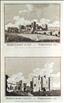
Richmond . The Antiquities of England and Wales was the product of Alexander Hogg who was well known as a partwork publisher. Under the claimed authorship of Henry Boswell it was issued serially from c1787-9, and subsequently made available as a complete work. The format was typically 2 (though sometimes up to 6) prints to a page, with one or two accompanying pages of descriptive text on each pair of subjects. It also included the set of English county maps by Thomas Kitchin first used in the London Magazine from 1747-54. Richmond Castle was founded Alan Rufus first Lord of Richmond, as part of the Norman pacification of northern England. It was completed in 1086, and stands at the head of Swaledale overlooking the River Swale. It was strengthened by Henry II, including the building of the stone keep, but thereafter decayed and was partially in ruins by 1538. In the early 19th century it was restored and used as the HQ of the North Yorkshire Militia, for whom a new barracks block was built in the courtyard. Today it is owned by English Heritage and opened to the public.
This print, engraved by Hawkins, is supplied with the original, accompanying text.
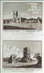
Bolton Castle. The Antiquities of England and Wales was the product of Alexander Hogg who was well known as a partwork publisher. Under the claimed authorship of Henry Boswell it was issued serially from c1787-9, and subsequently made available as a complete work. The format was typically 2 (though sometimes up to 6) prints to a page, with one or two accompanying pages of descriptive text on each pair of subjects. It also included the set of English county maps by Thomas Kitchin first used in the London Magazine from 1747-54. Bolton Castle was constructed between 1378-98 by Richard, first Baron Scrope of Bolton, on the eastern edge of the Yorkshire Dales. In 1630 the last member of the Scrope family died, and through the female line the property passed to the Powlett family. It is today still owned by the 8th Baron Powlett, and is opened to the public, and available for wedding hire. This print, engraved by Thornton, is supplied with the original, accompanying text. A few spots.
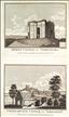
Middleham Castle. The Antiquities of England and Wales was the product of Alexander Hogg who was well known as a partwork publisher. Under the claimed authorship of Henry Boswell it was issued serially from c1787-9, and subsequently made available as a complete work. The format was typically 2 (though sometimes up to 6) prints to a page, with one or two accompanying pages of descriptive text on each pair of subjects. It also included the set of English county maps by Thomas Kitchin first used in the London Magazine from 1747-54. Middleham Castle, in Wensleydale, was buily by Robert Fitzrandolph, third Lord of Middleham from 1190. In 1270 it passed into the hands of the powerful Neville family, and was later the home of the future King Richard III who married Anne Neville in 1472. It remained a royal property after Richard's death at the Battle of Bosworth, until it was sold by James I, after which it fell into disrepair. Today the impressive ruins are managed by English Heritage and open to the public.This print, engarved by Thornton, offers two views on one sheet, and is supplied with the original, accompanying text. A few spots.

Coverham Abbey. The Antiquities of England and Wales was the product of Alexander Hogg who was well known as a partwork publisher. Under the claimed authorship of Henry Boswell it was issued serially from c1787-9, and subsequently made available as a complete work. The format was typically 2 (though sometimes up to 6) prints to a page, with one or two accompanying pages of descriptive text on each pair of subjects. It also included the set of English county maps by Thomas Kitchin first used in the London Magazine from 1747-54. Coverham Abbey was a Premonstratension house, first founded at Swainby in 1190, and then refounded at Coverham in c1212 by Ranulf Fitzralph.. It was badly damaged by Scottish raiders in the 14th century, but rebuilt. After the dissolution of the monasteries it fell into decay, although its guesthouse was incorporated into a private dwelling in 1674, which was rebuilt in the late 18th century as today's Covenham Abbey House. The other extant ruins on the site are also privately owned with no public access. This print, engraved by Eastgate, offers 2 views on 1 sheet, and is supplied with the original, accompanying text.
Fountains Abbey. The Antiquities of England and Wales was the product of Alexander Hogg who was well known as a partwork publisher. Under the claimed authorship of Henry Boswell it was issued serially from c1787-9, and subsequently made available as a complete work. The format was typically 2 (though sometimes up to 6) prints to a page, with one or two accompanying pages of descriptive text on each pair of subjects. It also included the set of English county maps by Thomas Kitchin first used in the London Magazine from 1747-54. Fountains Abbey was a Cistercian house founded by 13 monks expelled from St. May's Abbey in York in 1132, but offered a site for a new house in the Yorkshire Dales by the Archbishop of York. From modest biginnings in grew (in 2 major building phases) to become one of the largest and richest monastic sites in the country. After the dissolution of the monasteries the site passed through several owners, who robbed it of salvageable materials, before being combined with the neighbouring Studley Royal Estate of William Aislaby in 1767. The estate was purchased by the National Trust in 1983, and is today managed on their behalf by English Heritage, who open it to the public. This print, engraved by Eastgate, offers 2 views on 1 sheet, and is supplied with the original, accompanying text page and plan of the site.
Bowes & Coningsburgh Castles. The Antiquities of England and Wales was the product of Alexander Hogg who was well known as a partwork publisher. Under the claimed authorship of Henry Boswell it was issued serially from c1787-9, and subsequently made available as a complete work. The format was typically 2 (though sometimes up to 6) prints to a page, with one or two accompanying pages of descriptive text on each pair of subjects. It also included the set of English county maps by Thomas Kitchin first used in the London Magazine from 1747-54. The first Bowes Castle was built by Alan de Bretagne, Count of Brittanyaround 1386 within an old Roman fort. Henry II later rebuilt it in stone from 1171-4. Damaged in Scottish raods and by local insurgency, the castle was ruinous by 1340. Today it is owned by English Heritage who open it to the public. Coningsburgh or Conisburough Castle was built on the River Don shortly after the Norman conquest by William de Warenne, Earl of Srrey. It was rebuilt in stone in the late 12th century, but later suffered from subsidence and fell into decay. By the late 19th century it was a picturesque tourist attraction. A consortium undertook restoration in the 1990's and today it is maintained and opened to the public by English Heritage. This print, engraved by Eastgate, offers 2 views on 1 sheet, and is supplied with the original, accompanying text pages.

The Dropping Well at Knaresborough & a Cascade at Bolton Park. The Antiquities of England and Wales was the product of Alexander Hogg who was well known as a partwork publisher. Under the claimed authorship of Henry Boswell it was issued serially from c1787-9, and subsequently made available as a complete work. The format was typically 2 (though sometimes up to 6) prints to a page, with one or two accompanying pages of descriptive text on each pair of subjects. It also included the set of English county maps by Thomas Kitchin first used in the London Magazine from 1747-54. The Dropping Well at Knareborough is first recorded in 1538 when it was visited by King Henry VIII. By this date it was well known for the restorative power of its waters. It has also become famous for the mineral waters' ability to petrify objects exposed to them for a period of time, thus turning them to stone. Next to the well is Mother Shipton's Cave, the domicile of a 16th century prophetess, mystic and fortune teller. Both well and cave are today opened as a tourist attraction. Bolton Park is today the grounds of the Bolton Abbey Estate on the River Wharfe. These contain the ruins of Bolton Abbey, an Augustinian Priory dating from 1154. The Estate has been owned by the Cavendish family, Dukes of Devonshire, since 1748 and is open to the public.This anonymous print offers 2 views on 1 sheet, and is supplied with the original, accompanying text. A couple of brown marks to the margins.

York Minster. The Antiquities of England and Wales was the product of Alexander Hogg who was well known as a partwork publisher. Under the claimed authorship of Henry Boswell it was issued serially from c1787-9, and subsequently made available as a complete work. The format was typically 2 (though sometimes up to 6) prints to a page, with one or two accompanying pages of descriptive text on each pair of subjects. It also included the set of English county maps by Thomas Kitchin first used in the London Magazine from 1747-54. York was the seat of a Christian Bishops from Roman times, and the first recorded wooden church was built there in 627 AD, but the construction of today's cathdral began in 1080, after the Danes had destroyed the previous stone church on the site. Building continued for nearly 400 years, with changes in architectural style along the way, and the building was only finished and consecrated in 1472. The Minster is one of the largest cathedrals in Europe, and is particularly famed for its stained glass, much of which is medieval. It has been an Archbishopric since early times, with its Archbishop being the second most senior primate in the Church of England's hierarchy. This print, engraved by Thornton after a drawing by Hamilton, is supplied with the original, accompanying text.
A. Hogg Antiquities of England and Wales c1787-89
A Cascade at Bolton Park. The Antiquities of England and Wales was the product of Alexander Hogg who was well known as a partwork publisher. Under the claimed authorship of Henry Boswell it was issued serially from c1787-9, and subsequently made available as a complete work. The format was typically 2 (though sometimes up to 6) prints to a page, with one or two accompanying pages of descriptive text on each pair of subjects. It also included the set of English county maps by Thomas Kitchin first used in the London Magazine from 1747-54. Bolton Park is the estate of the Duke of Devonshire, and is located in the Yorkshire Dales near Skipton. The estate, which is open to the public, contains the ruins of Bolton Abbey and large areas of parkland and scenic country walks. The river Wharf runs through the estate, and at one point enter a narrow ravine called the Strid, which would appear to be the subject of this print.