W. Kip Camden's Britannia 1637 (1607)
The first five editions of Camden's successful history and topography of Britain were without maps, but for the sixth edition of 1607 the engravers William Hole and William Kip were commissioned to provide a set of maps of the counties of England and Wales, plus 3 general maps of the countries comprising the new "United Kingdom". These maps were retained for the subsequent 1610 and 1637 editions. They are based on the earlier work of Saxton, Norden, Smith and Owen. This attractively coloured example is from the 1637 edition.
J. Speed Theatre of the Empire of Great Britaine 1623-32 (1612)
John Speed's maps of the English and Welsh counties are amongst the most decorative of early, British cartographic work, and are eagerly sought after today. They were first published in 1612 in The Theatre of the Empire of Great Britaine, designed as a companion volume to Speed's History of Great Britaine. The maps were based on the earlier surveys of Saxton, Norden and a few others, with engraving contracted to Jodocus Hondius whose signature appears on 33 of the maps. Speed's greatest innovation was the inclusion of inset plans of major towns and cities. Although some were copied from earlier work, for many towns this was first plan ever published. Speed's county atlas was re-issued a number of times for a period of around 160 years, with new publishers making various small changes and updates to the maps over time. This example bears the imprint of Sudbury and Humble, dating its issue to between 1611 and 1654. Repair to centrefold.
J. Blaeu Theatrum Orbis Terrarum 1647,1648 or 1664 (1645)
The Blaeu family were one of the leading Dutch map producers of the 17th century. Their major work, the Theatrum Orbis Terrarum, later titled the Atlas Maior, was a multi volume world atlas initiated by Willem Blaeu and expanded by his son Joan. Their maps were beautifully designed and engraved, and are often found with original colour, making them most desirable to collectors. 1645 saw the first publication of volume 4 of the atlas, containing maps of England and Wales. There were several re-issues between then and 1672 when most of Blaeu's plates were lost in a fire which engulfed his Amsterdam premises. Dutch text to verso dates this example to 1647, 1648 or 1664. Original full colour. Repaired tears to top and lower centrefold well outside the printed area. Some soiling to margins, but the printed area generally clean and fresh.
Jan Jansson was one of Amsterdam's leading 17th century mapmakers, and a close rival to the Blaeu family. His multi-volume world atlas first saw the introduction of 6 maps of individual English counties into the German edition of 1636, and a further 11 of English and Welsh counties in the Dutch edition of 1644. But when Jansson saw the 1645 Blaeu volume with more decorative maps covering all the English and Welsh counties, he felt obliged to revise his existing plates and complete the set in order to compete. His new volume covering England and Wales was first published in the 1646 Latin text edition of the Atlas Novus. In 1694 the printing plates were acquired by the Amsterdam firm of Schenk and Valk who made various revisions, and sold the maps singly or in composite atlases. This example, covering both Hertfordshire and Middlesex, bears the Schenk and Valck imprint, and has had a graticule of latitude and longitude added. Original full colour.
R. Morden Magna Britannia et Hibernia 1718-39 (1701)
Morden's set of smaller maps may originally have been drawn and engraved for Camden's Britannia, but rejected as too small. They were first published in 1701 in The New Description and State of England. This example is from Magna Britannia et Hibernia, originally issued as a 92 part topographical work between 1714 and 1731, but gradually also made available in 6 finished, bound volumes. The text and map of Hertfordshire first appeared in the partwork in March 1718, but further editions were issued up to 1739 with the maps unchanged.
This map was part of a county set first published by Thomas Read in The English Traveller in 1746. It was subsequently re-issue in The Small English Atlas in 1753, 1762 and 1764, and finally in England Displayed in 1769. This example of the Hertforshire map is from the 1753 (first) edition of The Small Engkish Atlas, so identified by the faint traces of the previous, but now erased erased plate mark (24) just within the top-right neat line. Modern hand colour. The maps are often described as "Rocques" after John Rocque who published The Small Engish Atlas.
T. Kitchin The Antiquities of England and Wales c1789 (1748)
This map was first published in the May 1748 edition of the London Magazine, which between 1747 and 1754 issued a complete set of English county maps by Thomas Kitchin. The maps were later re-published by Alexander Hogg in Boswell's Antiquities of England & Wales, initially in partwork from c 1787-9, and then in several complete editions of the work up to 1798. This example of the Hertfordshire map is from the first complete edition of Boswell's Antiquities dating from c1789.
Original outline colour. Some repaired marginal nicks and tears not affecting the printed area. Some dampstaining to the side margins, but again well outside the printed area. Otherwise a very attractive specimen. This new series of maps was commenced in 1749, with maps sold singly until the last counties were completed and the full series issued in 1760 as the Large English Atlas. Hertfordshire was one of the first issued in 1749. J.Tinney's name on the imprint probably dates this copy to the first edition of the atlas in 1760, though it could have been sold individually as a pre-atlas copy between 1753 and 1760.
J. Ellis Ellis's English Atlas 1766 (1765)
Joseph Ellis's English Atlas was an entry into the market for small county atlases by its publishers Robert Sayer and Carington Bowles. The county maps were closely based upon those drawn by Thomas Kitchin for the 1763 topographical work England Illustrated, the major difference being the attractive vignettes which replaced Kitchin's rococco cartouches. The atlas was first published in 1765, and soon became a commercial success, running to many later editions. It was promoted as a travelling atlas, and made available in various formats. These included a version with the maps printed back to back on each page, as with this example from a 1766 edition which has a map of The Isle of Wight on the reverse.
J. Cary New and Correct English Atlas 1809 (1787)
The last decades of the 18th century saw less emphasis being placed on the traditions of decorative mapmaking in favour of a plainer style and design. Foremost amongst this new wave of "modern" cartographers and engravers was John Cary. The New and Correct English Atlas was Cary's first major production as a publisher in his own account. The maps were not only clearly and elegantly drawn and engraved, but also set new standards in accuracy in taking advantage of all the new large-scale county surveys of the second half of the 18th century. The atlas was first published in 1787, with a re-issue in 1793. By 1808 the plates were well worn, and the engraving of a new set was begun. The next dated edition of 1809, from which this example comes, utilised these new plates. Original outline colour.
Charles Smith was a successful London publisher and map-seller, whose work is stylistically very similar to that of John Cary. His large format New English Atlas first came to market in 1804, but many of the maps have also been found in folding format and may have been sold individually before the publication of the atlas. Smith's maps were well designed and accurate, making use of the large scale county surveys of the previous half-century. The atlas was a commercial success and was up-dated and re-published regularly until c1865 (the latter editions produced by lithographic transfer). This example is from the 1808 second edition, and is in bright and original full colour.
J. Cary New English Atlas 1811 (1809)
It is suprising that Cary's large county atlas was issued as late as 1809, as individual maps from it seem to have been sold singly from 1801. The atlas format was perhaps to compete with the similarly sized atlas of Charles Smith, which went under the same title and was published in 1804. It is perhaps Cary's finest production, the maps being notable for their fine design, detail and engraving. The atlas ran to several later editions by Cary, and the plates were later used for a variety of lithographic transfers by G.F. Cruchley. This example is from the second edition of 1811, and is in original full colour.
This work was published in 1835 as a companion volume to Lewis's Topographic Dictionary. It contains county and borough maps, drawn by R. Creighton and engaved by J.& C. Walker, and was designed to show the electoral and boundary changes effected by the 1832 Reform Act. There were 2 issues of the work in 1835 and 1840, this example of the county map being from the 1835 first edition. Original outline colour.
J. Walker British Atlas 1854 or 1856 (1835-7)
Maps for the Walkers' British Atlas were first issued singly in folding format between 1835 and 1837. When the series was complete they were then sold as a box set, and subsequently also issued in book format as a county atlas. The work ran to many subsequent editions with frequent updates to railways and other information. This example is from the editions of 1854 or 1856 - so dated from the railways shown, the publisher's imprint, and the population figures quoted. Full wash colour. A repaired tear to the lower margin entering the printed area by c3cms.
Thomas Moule's antiquarian leanings are evident in this series of highly decorative county maps - a stylistic throwback in an age when cartographic work had become much plainer and more utilitarian. The maps were engraved by W. Smollinger, J. Bingley and J. Dower, and first appeared in Moule's English Counties Delineated, a partwork with text issued from 1830-32. They were subsequently made available as a complete work in 1837 under the same title, and were later re-issued in Barclay's Universal English Dictionary between 1842 and 1852. This latter work ran to several editions and the maps were often updated between editions to show the latest growth of the railway network. This example is from one of the editions of Barclay's Dictionary between 1842 and 1852. Supplied mounted and ready to frame.
Originally intended as volume 3 of a larger cartographic project (The English Atlas), Richard Blome's Britannia was published alone in 1673. A rare second edition was issued in 1677. This Cambridgeshire map is from the first edition of the work, and was dedicated to James Cecil), third Earl Salisbury, better known as Viscount Cranborne of Essendon.Cecil served as MP for Hertfordshire and later became a privy councillor to James11, who also made him a Knight of the Garter.. Cecil fell out of royal favour after he was implicated in the Rye House Plot, and died young in 1683. In return for his patronage of Blome's project Cecil received this dedication on the county map, and also appeared in the list of the nobility and gentry of the county, his coat of arms being further included amongst the 816 illustrated in the volume. Mounted
J. Luffman A New Pocket Atlas and Geography of England and Wales 1806 (1803)
Luffman's atlas was designed as a geographical aid to children. It was first issued in 1803, with a second edition in 1806 which is distinguished, as with this example, by the positioning of the plate number immediately above the circular map. It is uncommon.
Harrison's atlas was published in 1791, but maps were engraved and dated between 1787 and 1791, and may have been sold singly as completed. Hertfordshire is dated 1788.
H. Moll The Historical Antiquities of Hertfordshire 1700
Sir Henry Chauncy's important work on Hertfordshire was published in 1700, apparently in a print run of 500 copies. Chauncy was an eminent lawyer and antiquarian. The work included this county map by Hermann Moll, and a few other town plans and views There was a much later republication of the work in 1826 (with a newly engraved county map), but this example is from the first edition of 1700. A tight right hand margin (as taken from the book), but without loss to the printed area.
This map, drawn and engraved by Benjamin Rees Davies, was first issued in the Weekly Dispatch Newspaper in 1860, as part of a series of maps published between 1857 and 1863. The subsequent history of the maps includes re-issues in The Dispatch Atlas in 1863, Cassell's Complete Atlas in 1863, Cassell's British Atlas in 1865, Bacon's County Atlas in 1869, and Bacon's New Large Scale Ordnance Atlas from 1883. This example is dated to an edition of the atlas between 1895 and 1897 from railway evidence, quoted population figures, and colour overprinting. All editions of the map were by lithographic transfer.
J. Seller Anglia Contracta/A History of England/Camden's Britannia Abridged 1695-1703
First published in Anglia Contracta in c1695, Seller's maps were subsequently reissued in A History of England in 1696, and in Camden's Britannia Abridged in 1701. They were later re-used in the 1780's in Grose's Antiquities of England and Wales, for which titles and scale-bars were changed, the maps also being set in a page of text. The Seller/Grose maps are common, the originals by Seller much less so.
A. Perrot L'Angleterre, ou Description Historique et Topographique du Royaume de la Grande-Bretagne 1824-35
The text for this French topographical work on Britain was written by George Depping, the maps being drawn by Aristide Perrot and engraved by A. Migneret. It was first published in 1824, with subsequent editions in 1828 and 1835. The maps often cover more than one county as in this example which also includes Bedfordshire, Huntingdonshire and Cambridgeshire. The surrounding decorative border shows the typical produce and wares of the counties. Original outline colour
J. Cross The History and Antiquities of the County of Hertford 1815
Robert Clutterbuck's county history was a 3 volume set, with volumes published in 1815, 1821 and 1827. The double page county map was drawn and engraved by Joseph Cross, and appeared in the first volume of 1815. Some old tape stains to the margins, not affecting printed area, and a couple of minor repairs to tears in the margin and to the lower centrefold - all without loss.
Britannia Depicta was one of 3 pocket-sized reductions of Ogilby's road book that appeared within an 18 month timeframe between 1719 and 1720. It was more innovative than the others in including much additional topographical and historical information (researched by John Owen) on the maps. The work was a commercial success and ran to many later editions up to c1764. Supplied mounted and ready to frame.
James Wallis's New British Atlas was first published in 1813 by S.A. Oddy. There was a second edition in 1816. This example is from the first edition and is dated 1812 on the imprint. It is in attractive, original, full wash colour.
E. Bowen The General Magazine of Arts and Sciences/The Natural History of England 1759
This map first appeared in the January 1759 number of Benjamin Martin's General Magazine of Arts and Sciences, a monthly partwork which between 1755 and 1762 included a series of county maps. The magazine's format was novel, each issue covering 5 (later 6) subject areas. The intention was that all those parts relating to any one subject could later be rebound into subject volumes, for which individual title pages would be issued. In 1763 title pages for a two volume set were issued for those parts relating to natural history. Subscribers could then, if so desired, rebind their original partworks, and new purchasers could purchase the completed work under the title, The Natural History of England. There were no later re-issues and the maps are today not common.
J. Bill The Abridgement of Camden's Britannia 1626
An attractive and rare county map, as the work was only ever printed in one edition with a print run suggested as just 200. The maps were copied from Saxton, and are notable as the first set of county maps to show latitude and longitude. A true collector's item from the rarest of English county atlases.
240
These maps (without the decorative borders) were first issued in 1821 in Miller's New Miniature Atlas. The plates were later acquired by William Darton who re-issued them as a miniature atlas, but also used the maps, now further embellished by country scenes, in this children's work. Reuben Ramble is an invented character. Original colour to the illustrations.
F. Vivares A History of the Ancient and Royal Foundation, called the Abbey of St. Alban… 1795
The author of this work was the Reverend Peter Newcome, rector of Shenley in Hertfordshire. It was published in two parts, the first in 1793 and the second in 1795, and there were no later re-issues. This map of the county was presumably issued in the second part as it is dated 1794 in the imprint. It was engraved by Francis Joseph Vivares, whose father Francis Vivares was also an engraver, specialising in landscape prints.Original colour to the boundaries, with modern colour to parks, major roads and some other features. An old repair to a tear, entering the left border by c8 cms resulting in some slight soiling, but without loss to the image. An uncommon item.
Camden's Britannia was first published in 1586. County maps by Kip and Hole were first added in 1607, being supplanted by those of Robert Morden for the five editions from 1695 to 1772. In 1789 a new translation of the work by Richard Gough was published by T. Payne and G.&J. Robinson, with updated and modernised maps by John Cary. The same maps were also later used in Cary's New British Atlas of 1805. They can be found uncoloured, with outline colour, or with full wash colour. This example is from the second Gough edition of Britannia, published in 1806 (though the map bears the date 1805).
Benjamin Rees Davies first drew this map for the Weekly Dispatch newspaper as part of a series published between 1857 and 1863. The Hertfordshire map was issued in 1860. The subsequent history of the maps includes re-issues in The Dispatch Atlas in 1863, Cassell's Complete Atlas in 1863, Cassell's British Atlas in 1865, Bacon's County Atlas in 1869, and Bacon's New Large Scale Ordnance Atlas from 1883. All editions of the maps were by lithographic transfer. This example is from The Weekly Dispatch Atlas, published in 1863. Later colour.
Gorhambury House. The New British Traveller was one of a number of publications by Alexander Hogg aiming to tap the bouyant market for works on British topography and antiquities. It included text on each couny, a set of county maps by T. Conder and others, and numerous copperplate prints by a variety of engravers. The work was initially issued in 60 parts from c 1783, and then as a complete work from 1784. This anonymous print shows Old Gorhambury House, an Elizabethan mansion close to St. Albans. This house was replaced by a new Palladian mansion built between 1777 and 1784, after which the old house was left to decay. Its ruins are today maintained by English Heritage with free public access. The new house survives as the home of the Earl of Verulam. For ease of mounting the print is remargined to the lower border where separated from an adjoing view.

St. Albans Abbey . The Antiquities of England and Wales was the product of Alexander Hogg who was well known as a partwork publisher. Under the claimed authorship of Henry Boswell it was issued serially from c1787-9, and subsequently made available as a complete work. The format was typically two (though sometimes up to 6) prints to a page, with one or two accompanying pages of descriptive text on each pair of subjects. It also included the set of English county maps by Thomas Kitchin first used in the London Magazine from 1747-54. St. Albans Abbey is believed to have been founded by King Offa II of Mercia in the 8th century, but had to be substantially rebuilt after damage in Danish raids, and the modern building was only completed by its first Norman abbot in1089. After the dissolution of the monasteries the Abbey Church became the town's Parish Church, and later achieved cathedral status in 1877. Much of the stone used to construct the Abbey was robbed from the Roman remains at adjoining Verulamium. This print was engraved by Taylor, and is supplied with the original accompanying text from the work. A few brown spots to the sky.
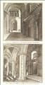
St. Albans Abbey . The Antiquities of England and Wales was the product of Alexander Hogg who was well known as a partwork publisher. Under the claimed authorship of Henry Boswell it was issued serially from c1787-9, and subsequently made available as a complete work. The format was typically two (though sometimes up to 6) prints to a page, with one or two accompanying pages of descriptive text on each pair of subjects. It also included the set of English county maps by Thomas Kitchin first used in the London Magazine from 1747-54. St. Albans Abbey is believed to have been founded by King Offa II of Mercia in the 8th century, but had to be substantially rebuilt after damage in Danish raids, and the modern building was only completed by its first Norman abbot in1089. After the dissolution of the monasteries the Abbey Church became the town's Parish Church, and later achieved cathedral status in 1877. Much of the stone used to construct the Abbey was robbed from the Roman remains at adjoining Verulamium. This print offers 2 interior views of the Abbey.
A Canal at Gubbins House. The Antiquities of England and Wales was the product of Alexander Hogg who was well known as a partwork publisher. Under the claimed authorship of Henry Boswell it was issued serially from c1787-9, and subsequently made available as a complete work. The format was typically two (though sometimes up to 6) prints to a page, with one or two accompanying pages of descriptive text on each pair of subjects. It also included the set of English county maps by Thomas Kitchin first used in the London Magazine from 1747-54. The More family had owned the manor of Gobions (or Gubbins - near Potters Bar) since the 13th century, and built a new house there in the early 1500's. It was the home of Henry VIII's chancellor, Sir Thomas More. In later years the estate was merged with that of Brookmans Park, and the house was pulled down in c1838. This print was engraved by Taylor, and shows a view of the gardens.
Hitchin Priory. The Antiquities of England and Wales was the product of Alexander Hogg who was well known as a partwork publisher. Under the claimed authorship of Henry Boswell it was issued serially from c1787-9, and subsequently made available as a complete work. The format was typically two (though sometimes up to 6) prints to a page, with one or two accompanying pages of descriptive text on each pair of subjects. It also included the set of English county maps by Thomas Kitchin first used in the London Magazine from 1747-54. Hitchin Priory was founded in 1317 as a house for White Carmelite Friars. After the dissolution of the monasteries it was converted into a country house but gradually decayed. A few fragments of the original building survive today, having been incorporated into the fabric of the18th century mansion, now a hotel and known by the name of Hitchin Priory.
Minsden Chapel, near Hitchin. The Antiquities of England and Wales was the product of Alexander Hogg who was well known as a partwork publisher. Under the claimed authorship of Henry Boswell it was issued serially from c1787-9, and subsequently made available as a complete work. The format was typically two (though sometimes up to 6) prints to a page, with one or two accompanying pages of descriptive text on each pair of subjects. It also included the set of English county maps by Thomas Kitchin first used in the London Magazine from 1747-54. Minsden Chapel dates from the 14th century, but was derelict by the 1600's Its overgrown ruins still stand in fields in the parish of Preston, and are today the haunt of ghost hunters.
Anon. The European Magazine 1797
Otter's Pool, Watford. The European Magazine was published from 1792 until 1826, eventually building into 89 volumes. It offered an range of content and competed with the Gentleman's Magazine and others. There are no artist or engraver's signatures, the imprint bearing only the name of the publisher J. Sewell, who founded the magazine. Otterspool is a small settlement on the river Colne to the east of Watford town centre. It was clearly once a rural idyll.
The Bridgewater Monument, Ashridge Park. The British Gazetteer was authored by B. Clarke and published by H.G. Collins in 1852. Apart from topographical text listings, it included a set of county maps (originally by Rowe), and a small series of railway prints after drawings by J.F. Burrell. This print was engraved by A. Ashley, and shows the Bridgewater Monument in the grounds of Ashridge Park. The monument was erected in 1832 as a monument to the 3rd Duke of Bridgewater, whose family owned the estate, and who was a great canal builder. Much of Ashridge Park, including the site of the monument which can be climbed by an interior staircase, is now owned by the National Trust and is open to the public free of charge.